
22 ka adlaw
Dali nga mga Kamatuoran
Transportasyon sa yuta sa Nepal
Mga hotel ug akomodasyon sa tea-house
Tanang pagkaon gawas sa Kathmandu
Giya nga tour ug trek sa tibuok biyahe
Ting-init, Tingdagdag
kasarangan
Nepal
6,300 m
Kathmandu - Besishahar - Humde - Chulu East - Manang - Muktinath - Pokhara- Kathmandu


Why Chulu East Peak Climbing?
- Opportunity to explore the Annapurna circuit area
- Enjoying the beauty of Tilicho Lake
- We see the mesmerizing panoramic view of the Annapurna, Dhaulagiri, and Manaslu
- Himalayan ranges.
- Memories from old monasteries and Gurung village at the Annapurna trekking route
- Excellent practice peak to climb in a lifetime.
Overview sa Biyahe
Chulu East Peak Climbing is one of the most popular adventurous peak climbs in the Annapurna range. This Chulu East Peak Climbing starts from Besishahar and follows a gradually ascending trail along the Marshyangdi River Valley to Pisang. You’ll leave the main course from Pisang and head up to Chulu East Base Camp.
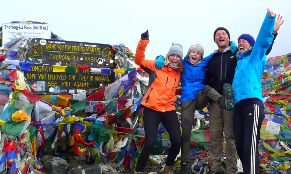
Chulu Far East Peak climbing summit day starts early in the morning with an easy scramble along rocky ridges to a glacier. Via a steep snow headwall, you go up to the summit. On your way back, you’ll rejoin the main trail again as you trek in the Kali Gandaki Valley, crossing Thorung La Pass (5,416m/17,769ft) down again to Jomsom.
This trip offers you breathtaking views of Annapurna II (7,937m/26,040ft), Annapurna III (7,555m/24,786ft), and Annapurna IV (7,525m/24,688ft), Gangapurna (7,455m/24,458ft), Glacier Dome, Dhaulagiri (8,167m/26,794ft), Tilicho Peak (7,134m/23,405ft) and Manaslu (8,156m/26,758ft).
Customized itineraries with base camp service and full board climbing packages are also available on request.
We also offer Chulu East Peak Climbing, a training course led by our experienced climbing guide. To be sure, you climb Chulu East Peak safely and return successfully. Chulu East Peak Climbing is a training requirement for our climbing guides. Just be sure to climb Chulu East Peak safely and return safely.
Ang labing kaayo nga oras alang sa Chulu East Peak Climbing is from March to May and October to December, in the spring and autumn seasons. These two seasons are suitable for climbing. Peak climbing in Nepal is possible on a private and group-joining basis.
Chulu East Peak Climbing Itinerary
Adlaw nga 01: Pag-abot sa Kathmandu
Once you arrive in Kathmandu, our team staff will pick you up there. They will introduce themselves and transfer you to a hotel, where you can refresh yourself. After a short nap in the evening, we can walk on the street to see the beauty of the night in Kathmandu.
Dinner
Hotel
1,400 m / 4,593 p
Adlaw nga 02: Mga talan-awon sa Kathmandu
Our team members thoroughly guided your sightseeing. During the day trip, you can visit several historical places in Kathmandu. First, you can visit the Pashupatinath temple, where you can see Hindu rituals, and the Boudhanath Stupa, a sacred Buddhist pilgrimage site. Basantapur Durbar Square covers the ancient history of the King. Due to the time factor, if possible, you will visit different places, and at night you will return to your hotel.
Pamahaw paniudto panihapon
Hotel
1,400 m / 4,593 p
Adlaw nga 03: First drive day to Chame
After spending two days in Kathmandu, we will drive you to Chame. 7-8 hrs of driving will take you to Chame via the Prithvi Highway. After crossing Kathmandu, you can enjoy a greener environment throughout the Trisuli River. From Mugling, we cross the Marsyangdi River and pass many villages before arriving at Chame.
Pamahaw paniudto panihapon
Teahouse
237.5 km
2,670 m / 8,760 p
8 hrs
Adlaw nga 04: Trek to Pisang
After breakfast at Chame the following day, your trek begins with a magnificent view of Mt. Annapurna. Your walking routes consist of pine forests with a slope down to the river. The walk up to Pisang is quite happening as it follows the Annapurna Circuit trek.
Pamahaw paniudto panihapon
Teahouse
10 km / 6.2 ka mga milya
3,300 m / 10,827 p
5hrs
Adlaw nga 05: Pisang to Humde village
We’ll leave Pisang after breakfast and proceed to Humde Village. Walking the trail with magnificent mountain views, rising hills, and a monastery is much more enjoyable. This hike is a bit easier than last time, as there are fewer climbs and the dusty roads pass through well-placed rock walls.
Humde, well known for its airport, is a lovely town in Manang’s east. The airfield is around 2.5 kilometers from Manang’s center of attraction. The entire village of Humde is crammed with spectacular mountain and landscape vistas.
Pamahaw paniudto panihapon
Teahouse
8 km / 5.0 ka mga milya
3,300 m / 10,827 p
4hrs
Adlaw nga 06: Trek to julu khola
After a night at Humde village, another trek begins. The hike continued until we could not find Yak Kharka, with stunning views from here, such as snow-capped peaks, dramatic high cliffs, and a monolith that caught our eyes. There is a Pine forest with Himalayan scenery until reaching Jhulu Khola.
Pamahaw paniudto panihapon
Teahouse
10 km / 6.2 ka mga milya
4,640 m / 15,223 p
5hrs
Adlaw nga 07: Acclimatization at Jhulu Khola
As Julu Khola lies at an altitude of around 4640 masl, you need to acclimate yourself for the further hike. After breakfast, you can explore a nearby village by stepping slowly.
Beautiful panoramic landscapes, clear mountain views, and village culture make your short hike worthwhile. One day of Chulu Peak climbing, resting at Julu Khola helps you cope with high altitude sickness as you go further
Pamahaw paniudto panihapon
Teahouse
3 km / 1.9 ka mga milya
4,640 m / 15,223 p
2hrs
Adlaw nga 08: Trek to Chulu East Base Camp
We’ll be heading down the path now, after spending the acclimatization day at Julu Khola and feeling rejuvenated. As we leave the settlement, we’ll take the route that rises uphill to meet Chulu East Base Camp. This section is more accessible than Island Peak climbing.
The trail to Chulu East becomes arduous as it passes over rocky sedimentary sequences. To get to Chulu Far East Base Camp, we’ll have to scramble along the trail for another 6 hours, where we’ll camp overnight.
Pamahaw paniudto panihapon
Kampo
12 km / 7.5 ka mga milya
5,050 m / 16,568 p
6hrs
Adlaw nga 09: Acclitamize at Chulu East base camp
The hilly trails and icy terrain make walking from the Chul East Base Camp difficult and tiring. Walking too fast can cause physical pain and difficulty breathing. As a result, we rest for the day and allow the body to adapt to lower oxygen levels in the air.
Instead of just hanging out and killing time, go around the base camp and visit a quieter place. To adapt, take a walk in many areas with steep uphill slopes and spectacular mountain views. We return to the camp and sleep soundly when the sun goes down.
Pamahaw paniudto panihapon
Kampo
5,050 m / 16,568 p
Adlaw nga 10: Trek to Chulu East High Camp
We may now hike up the sloping trail to Chulu East High Camp, at an elevation of 5600 masl. You can see Pisang Peak, Annapurna Mountains, and Chulu West on the way. Spending time in high camps is just as enjoyable, with stunning views of the surrounding countryside and the colorful valleys beneath
As the path for the Chulu Nepal climb progresses, it passes through snowy hills that can only be negotiated with safety gear. The trail continues uphill, which is grueling and takes a long time, around 8-10 hours. Our team will set up tents and make suitable arrangements for climbing Chul East Peak.
Pamahaw paniudto panihapon
Kampo
9 km / 5.6 ka mga milya
5,600 m / 18,373 p
9hrs
Adlaw nga 11: Chulu East Peak Summit
It’s the day that will determine whether our days of struggle and our workforce on the trail were worthwhile. So, with a backpack full of gear, we’ll walk steadily to the path that passes among icebergs and snowfields.
You will finally reach the summit after trekking through the towering cliffs, icy slopes, and open canyons for about 11 hours.
From the top, you can enjoy the breathtaking views of Annapurna II, the Glacier Dome, and Dhaulagiri in space. After visiting the hidden glaciers and mountains, we take a step back and retrace our route to the base camp.
Pamahaw paniudto panihapon
Kampo
12 km / 7.5 ka mga milya
6,584 m / 21,601 p
11hrs
Adlaw nga 12: Pagbaktas paingon kang Manang
It’s time to get back on the trail after that beautiful adventure to the peak of Chulu East Peak. After stepping down to base camp, as soon as possible, we head for Manang, a significant destination for the Annapurna Circuit trek.
The calm trail leads to wonderful Khangsar with beautiful vistas. We’ll have simple access to Khangsar village by crossing the Khangsar Khola bridge. We’ll continue on an uphill hike that offers a stunning view of Chulu East and the surrounding mountains. After more than 8 hours of trekking north of the base camp, you will arrive at Khangsar village.
Pamahaw paniudto panihapon
Teahouse
18 km / 11.2 ka mga milya
3,750 m / 12,303 p
8hrs
Adlaw nga 13: Trek to Siri Kharka
Trekking takes more than 7 hours, so it will be tiring on your way to Siri Kharka. The road is long and uphill, requiring a lot of physical strength.
After crossing Khangsar Khola, drive towards Shree Kharka village. Once in the town, you can go sightseeing, see the blue sheep, and interact with the locals.
Pamahaw paniudto panihapon
Teahouse
15 km / 9.3 ka mga milya
4,060 m / 13,320 p
7hrs
Adlaw nga 14: Trek to Tillicho base camp
After 7-8 hours of trekking from Siri Kharka, you will arrive at Tilicho Base Camp. Hiking to the Tilicho base camp is more accessible than trekking to Siri Kharka. We’ll then descend the slope on a narrow track that passes through landslide-prone sections.
Passing subglacial lakes and glaciers makes the trek to Lake Tilicho difficult. It’s fun to see, but walking the trails is difficult and unpleasant. There is a chance to find wild creatures and birds while traveling through the wild forest.
Pamahaw paniudto panihapon
Tolda
18 km / 11.2 ka mga milya
4,900 m / 16,076 p
8hrs
Adlaw nga 15: Trek to Tillicho lake
Early mornings are ideal for viewing Tilicho Lake’s pristine beauty, so get up an hour early to experience this core experience. We’ll eat breakfast shortly before our journey begins by crossing permafrost and frozen paths.
The lake’s beauty is unaffected by seasonal fluctuations. It is surrounded by lofty mountains that continuously provide the lake with fresh water. We’ll return to the route and walk gently after exploring the sequence of mountains and vibrantly blue water.
Pamahaw paniudto panihapon
Teahouse
4 km / 2.5 ka mga milya
4,919 m / 16,138 p
3hrs
Adlaw nga 16: Pagbaktas paingon sa Yak Kharka
After having a great time on Lake Tilicho, we head straight to the trail. Follow the snow-covered, fluffy path and cross the Meso Cantara Pass at 5120 meters. The route requires a lot of hard climbing, so keep that in mind when walking the trails.
A wooden bridge will guide you through an unmarked route across the Thorung Khola River. We are spending the rest of our time exploring communities once we get to Yak Kharka after a 7-hour journey
Pamahaw paniudto panihapon
Teahouse
15 km / 9.3 ka mga milya
5,120 m / 16,798 p
7hrs
Adlaw nga 17: Pagbaktas paingon sa Jomsom
After descending the trail from Yak Kharka, we’ll head north to Marpha. This charming community is known for its apple orchard. We’ll continue on an easy path into Jomsom, the administrative centre of Mustang District.
Historical museums, medieval monasteries, and manuscripts abound in this magnificent location. Glistening white mountains and landscapes makes the mesmerizing moment. Jomsom is located at an altitude of 2743 masl.
You can also walk towards Ibabaw nga Mustang gikan diri.
Pamahaw paniudto panihapon
Teahouse
18 km / 11.2 ka mga milya
4,050 m / 13,287 p
6hrs
Adlaw nga 18: Flight to the Pokhara
After exploring the Jomsom, you can take a scenic flight to the Pokhara. The flight to Pokhara takes around 20 to 25 minutes, during which time we get to see a variety of mountains and waterfalls.
At Pokhara, you can visit Barahi Temple and other exciting places. I spent the evening watching the sunset and Machhapuchhare on Phewa Lake. Return to the hotel before dinner and have a good night’s rest.
Pamahaw paniudto panihapon
Hotel
2,743 m / 8,999 p
Adlaw nga 19-20: Reserve Day
The purpose of Reserve Day is to offer trekkers extra time in case they get altitude sickness. It’s utilized when hiking is hampered by inclement weather like thick snow, strong winds, or haze. Reserve Day also helps with Chulu East Peak Climbing adaptability and training.
Pamahaw paniudto panihapon
Teahouse
5,050 m / 16,568 p
Adlaw nga 21: Drive to the Kathmandu
Take a tourist bus from Pokhara to Kathmandu, which takes around seven hours, or fly for about 25 minutes and spend the night at a hotel. You can take a short evening night out in Kathmandu.
Pamahaw paniudto panihapon
Hotel
820 m / 2,690 p
Adlaw nga 22: Katapusan nga Pagbiya
Our team members will drop you off at the airport for your final flight. It’s time to bid farewell with the beautiful memories of the trip in our minds.
pamahaw
1,338 m / 4,390 p
Chulu East Peak Climbing Map

Unsay Madahom?
Unsay naapil
- Four nights of Hotel accommodations in Kathmandu on a B/B basis;
- Pick up and drop from Kathmandu airport to the airport.
- Three meals a day (Breakfasts, Lunch, and Dinners with tea or coffee) during the trek
- Climbing period & overnight in a tent.
- Trekking Permit (National Park entry fee)
- TIMS card (Trekking Information Management System) Permit
- Climbing permit
- Necessary staff during the trekking and climbing period With Experience Guide and Porter experienced
- Government license holder Climbing guide during the climbing period as per group size.
- Group medical supplies (First Aid medical kit will be available)
- One tent will be open in the Base camp for two people on a shared basis;
- High-altitude food and all climbing crew will be available above the base camp.
- Necessary fixed and dynamic ropes will be available during the climbing period.
- The necessary kitchen crew will be available in the base camp
- Complete pre-departure information, flight ticket reconfirmation and extend visa service(if required)
- Farewell Dinner in Kathmandu before departure.
Unsa ang Wala iapil
- Paniudto ug panihapon sa Kathmandu.
- Emergency rescue evacuation if required.
- Airfare international flights
- Any Alcoholic, hot and cold drinks, hot shower.
- Personal nga kagamitan sa pagsaka
- Icefall fees Garbage Deposit (Sharing with other members) if applicable.
- Insurance nga Travel
Mga Review sa Tripadvisor
Mga Review sa Google
Chulu East Peak Climbing Additional Information
Chulu East Peak Climbing Cost
The Chulu East Climbing Cost is somewhere between 2250-2400 USD. Cost depends upon whether you are with a group or solo. MyEverestTrip provides the best facility with suitable accommodation and food during your trek. Our motto is to make the trekkers happy by providing a secure and good facility at a lower cost. Prices are subject to mutual agreement.
That is, if you want to add some services, you will be charged for these additional services, and if you want to reduce certain services, you will be charged less. This Chulu East Nepal trek route will change depending on time and requirements.
Chulu East peak climb cost includes:
- Pick up from Kathmandu International Airport with a private vehicle as you arrive in Kathmandu.
- Two nights accommodation at a deluxe room in Kathmandu and one night in Pokhara.
- Depending on the number of people at your party, there will be one expert cook and kitchen staff.
- During the walk, several porters are required (one porter equals one passenger).
- Transportation by Micro Bus from Kathmandu to Chame and back.
- You’ll stay in a guest house while hiking, and on climbing days, you’ll stay in a tent.
- Fees for climbing Chulu East Peak, Guide Bonus, and Chulu Peak Guide Insurance.
- Oxygen meter for checking heart rate, pulse, and atmospheric oxygen levels at high altitude
- Annapurna Conservation Area Entry Permit
- Peak climbing Permit.
- TIMS card.
- Mga buhis sa gobyerno
- Mapa sa Trekking
- Medical kit
Chulu East Nepal Climb Difficulty
This Chulut East Nepal peak climbing is moderate to great difficulty; you need a sense of adventure and a commitment to reaching the top. It cannot be compared to the Everest Expedition regarding problems, but it is also not a simple summit. On the other hand, this Chulu Far East Climb Adventure will enchant you with its enthralling and beautiful trek to the glorious pinnacle of Chulu Far East Nepal.
In rugged and challenging terrain, trails are full of climbs and canyons. You also have to walk along with the snow and glacier. The trek requires a daily walk of 6 to 7 hours, which can be extended to 8 or 9 hours. To go on this adventurous tour, you must be in good health and have a high level of physical fitness. In addition, prior trekking experience is required.
Altitude is an essential factor in the climbing program for Chulu East Peak. You spend most of your time above 2,500 meters. There’s a chance you’ll get altitude sickness if you go higher than the referenced height. Suppose your body does not fully acclimate to the elevation; the risk of altitude sickness increases. As a result, we’ve planned our itinerary to include plenty of relaxation days.
Training for Chulu East Nepal climb: Regular cardiovascular training at home, such as cycling, swimming, hill climbing, and lots of walking, can help you prepare. You can mentally prepare yourself for a daily walk of 5 to 6 hours on the trek. Seek out hills or a tall building and go up and down the stairwells several times. It may be helpful for your Chulu Peak Climb.
Chulu East Peak Climbing Permits
Trekkers should contact recognized trekking agencies, who could apply for Chulu East permits (on their behalf) at the Department of Immigration, completing all relevant paperwork. Trekkers should travel in a group (minimum of two people) with a qualified trekking guide. Individual trekkers are not eligible to apply for a Chulu peak permit.
The permit is in US dollars but must be paid in Nepalese rupees. No trekking permit for Chulu East Peak will be issued after your visa has expired. For this reason, the trekker must have a valid visa for enough days to cover the entire trekking route.
Trek permit includes
- Fees for entering the Annapurna Conservation Area and obtaining a TIMS (Trekkers’ Information Management System) card.
- Nepal Mountaineering Association climbing permit for Chulu East Nepal
Best season for Chulu Peak Climbing
Caution should be taken when planning challenging activities such as the Chulu Peak Climb, as the season can significantly impact your trip’s overall outcome. Spring and autumn are the ideal hiking seasons to start your Chulu East Peak Climbing. The highest number of trekkers can be seen during these seasons. The weather is likely to be pleasant in the spring (March-May) and fall (September-November), with clear blue skies and spectacular panoramic views of mountains.
We recommend you choose this season for your lifetime trekking adventures.
We strictly ask you to avoid Chulu East peak in Summer/ Monsoon, i.e., June to July, and Winter, i.e., January to February.
Chulu East Peak Climbing FAQs
Is the best season for Chulu East Peak Climbing?
Caution should be taken when planning challenging activities such as the Chulu Peak Climb, as the season can significantly impact your trip’s overall outcome. Spring and autumn are the ideal hiking seasons to start your Chulu East Peak Climbing. The highest number of trekkers can be seen during these seasons.
The weather is likely to be pleasant in the spring (March-May) and fall (September-November), with clear blue skies and spectacular panoramic views of mountains.
We recommend you choose this season for your lifetime trekking adventures. We strictly ask you to avoid Chulu East peak in Summer/ Monsoon, i.e., June to July, and Winter, i.e., January to February.
Can you do the Chulu East Peal Climb Solo?
You can trek Solo in Chulu East but you must hire a guide. You will not have to worry about your safety, whether on a solo or a group trip. As you know, travelling solo itself is an adventure, but not on all routes. Due to long trekking routes, you may have problems carrying bags and navigating.
So having a Porter and Guide for your Chulu East Nepal trek would be best. That is Why the Government of Nepal doesn’t issue permits for Solo or group trekkers unless you hire a guide.
How to Train for Chulu Fast East Trek?
Focus on cardio as there is less accessible oxygen in the air at higher altitudes. Cardio helps you to vole with that. When trekking, you may need to start with strength training—practice hiking at a slightly higher altitude than you are accustomed to. You can also exercise in the gym. One of Nepal’s best hiking training for peak climbing is to run at least 4-5 times a week for 30 minutes.
What kind of Accommodation Do I Get?
There are hotels, lodges, and tented camps throughout your journey. All rooms will be shared, with two people per room in hotels and motels and two people per camp in case of a tent.
We start to set up camps from the Chulu Base Camp for a few nights. The staff will help set up the camps and prepare warm food for the day.
How long is the Chulu far East climb itinerary?
The entire itinerary will take about 20 days from arrival in Kathmandu to return to your home country. If you want to complete your mountaineering expedition within two weeks, you can do it. But, in the high Himalayas, there is a chance to quickly change altitude sickness and climate.
Changing weather also affects your trekking time. If you face frequent altitude sickness, we need more acclimatization days, which can lengthen your Chulu trek journey.
US$ 2,580 matag tawo
- Pinakamaayo nga Garantiya sa Presyo
- Luwas nga Sistema sa Pagbayad
- Gipahaom ug Personal nga Itinerary
- 70% nga balik-balik nga mga kustomer
24 Oras, 7 ka Oras nga Suporta

Puru (+977-9851069558)