Kyk gerus na ons Manaslu-kringstapkaart om meer te leer oor die streek se belangrikste plekke, besienswaardighede en skoonheid. Vir 'n stapavontuur het die Manaslu-streek gewild geword onder stap-entoesiaste. Die afgesonderde paaie, geïsoleerde natuur en asemrowende skoonheid lok toeriste van regoor die wêreld. Die staptog bied asemrowende uitsigte op Mount Manaslu, die 8ste hoogste berg ter wêreld.
Die Manaslu-stapkaart gee jou gedetailleerde inligting oor al die belangrike plekke, die afstand en hoogte wat jy sal bereik, en die roete wat jy sal neem. As jy 'n kaart saam het, beteken dit dat jy 'n gids sal hê. Dit word ook sterk aanbeveel dat jy 'n kaart op die reis saamneem. Dit bied jou behoorlike rigting en hulp met navigasie.
Die Manaslu Circuit Trek is minder druk, wat beteken minder mense is op die roete. Dus, om hulp van ander te soek, is nogal uitdagend op die reis. As jy die moeilikheidsgraad van die avontuur wil verstaan, kan 'n kaart jou ook daarmee help. Wil jy meer verstaan oor die Manaslu Circuit TrekHierdie gids is vir jou.
INHOUDSOPGAWE
Hoogtepunte van die Manaslu-kringreis
- Kry 'n nabyskou van Mount Manaslu, die agtste hoogste berg, saam met die hoogste pieke van Annapurna, Ganesh Himal, Cheo Himal en Ngadi Chili.
- Geniet die Tibetaans-geïnspireerde kultuur en tradisies van die Gurung- en Magar-mense.
- Maak 'n pad deur afgesonderde paaie en geniet die rustige roete wat jou nader aan die natuur bring.
- Om jouself uit te daag met die staptog en 'n gevoel van voldoening te kry na die voltooiing van die reis.
- Groot gevoel van prestasie deur oorwinning Larkya La (5,160m)
- Jy sal die kans kry om wildspesies soos Rooi Pandas, Sneeu-luiperds, Arende, Muskusherte en Himalaja-Tahr te sien, saam met diverse flora.
- Kan jy 'n pad deur die stegie en die Manaslu-bewaringsgebied maak? Budhi Gandaki V
Manaslu-kringstaproete
Die Manaslu-kringtrek begin met 'n avontuurrit van Kathmandu na Soti Khola. Die staptog begin op die tweede dag. Die eerste dorpie waar ons sal stop, is Machha Khola, gevolg deur Jagat en Deng. Soos ons op pad is, sal ons op die oewer van die Budhi Gandaki-rivier stap, hangbrûe oorsteek en deur welige woude en terrasvelde gaan.
Soos ons hoër van hierdie plek af beweeg, Die roete raak meer uitdagend, veral soos ons nader kom die dorpies Samagaon en Samdo. Ons sal asemrowende uitsigte oor Manaslu en ander pieke dwarsdeur die trek geniet. As jy gelukkig genoeg is, kan jy ook die seldsame fauna van die streek aanskou. Deur die Larkya La-pas, die hoogste punt van die staptog op 5 106 meter, sal die mees uitdagende deel wees, maar dit sal ons beloon met asemrowende berguitsigte.
Sodra ons die pas bereik, begin ons afdraande reis. Ons sal deur dorpies soos Bimthang en Tilije afdaal deur pragtige landskappe en woude. Die reis sal eindig in Dharapani, waar ons na Kathmandu sal terugkeer. Die avontuur duur ongeveer 12 dae, wat jou toelaat om dit binne 12 dae te voltooi en pragtige herinneringe van kulturele ontmoetings, natuurskoon en uitstekende prestasies te skep.
12 Dae Reisplan van Manaslu Circuit Trek
As jy by ons bespreek, bied ons jou 12 dae van die Manaslu Circuit Trek vir $920 per persoon. Hier is 'n uiteensetting van ons reisplan. Jy kan ook jou reisplan vir jou gerief aanpas.
Dag 01: Ry van Katmandu na Maccha Khola
- Kathmandu Hoogte: 1400m
- Maccha Khola Hoogte: 900m
- Hoogteverlies: 500m
- Rytyd: 8-9 uur
Dag 02: Trekking van Maccha Khola na Jagat
- Maccha Khola Hoogte: 900m
- Jagat Hoogte: 1410m
- Hoogtewins: 1 940 m
- Stapduur: 6-7 uur
Dag 03: Staptog van Jagat na Deng
- Jagat Hoogte: 1410m
- Deng Hoogte: 1804m
- Hoogtewins: 1 940 m
- Stapduur: 6-7 uur
Dag 04: Trekking van Deng na Namrung
- Deng Hoogte: 1804m
- Namrung Hoogte: 2630m
- Hoogtewins: 1 940 m
- Stapduur: 6-7 uur
Dag 05: Staptog van Namrung na Lho
- Namrung Hoogte: 2630m
- Lho Hoogte: 3180m
- Hoogtewins: 1 940 m
- Stapduur: 5-6 uur
Dag 06: Staptog van Lho na Samagaon
- Lho Hoogte: 3180m
- Samagaon Hoogte: 3530m
- Hoogtewins: 1 940 m
- Stapduur: 4-5 uur
Dag 07: Akklimatisering by Samagaon
Dag 08: Staptog van Samagaon na Samdo
- Samagaon Hoogte: 3530m
- Samdo Hoogte: 3860m
- Hoogtewins: 1 940 m
- Stapduur: 4-5 uur
Dag 09: Staptog van Samdo na Dharamsala
- Samdo Hoogte: 3860m
- Dharamsala Hoogte: 4460m
- Hoogtewins: 1 940 m
- Stapduur: 4-5 uur
Dag 10: Trekking van Dharamsala na Larkya La na Bimthang Village
- Dharamsala Hoogte: 4460m
- Larkya La Hoogte: 5160
- Hoogtewins: 1 940 m
- Bimthang Hoogte: 3720m
- Stapduur: 8-9 uur
Dag 11: Staptog vanaf Bimthang-dorp na Dharapani
- Bimthang Hoogte: 3720m
- Dharapani Hoogte: 2300m
- Hoogteverlies: 1420m
- Stapduur: 7-8 uur
Dag 12: Ry deur van Dharapani na Kathmandu
- Dharapani Hoogte: 2300m
- Kathmandu Hoogte: 1400m
- Hoogteverlies: 900m
- Totale duur: 8-9 uur
Manaslu Circuit Trek Hoogte & Totale Afstand
| Dag | Route | Elevation | Afstand | Datums |
| 1 | Ry van Kathmandu na Maccha Khola | 900 m | 120 km | 8-9 uur |
| 2 | Trek van Maccha Khola na Jagat | 1410 m | 14 km | 6-7 uur |
| 3 | Trek van Jagat na Deng | 1804 m | 19 km | 6 7 om |
| 4 | Staptog van Deng na Namrung | 2630 m | 19 km | 6-7 uur |
| 5 | Staptog van Namrung na Lho | 3120 m | 10 km | 5-6 uur |
| 6 | Stap van Lho na Samagaon | 3530 m | 13 km | 4-5 uur |
| 7 | Akklimatisering by Samagaon | 3530 m | - | - |
| 8 | Trek van Samagaon na Samdo | 3860 m | 10 km | 4 -5 uur |
| 9 | Staptog van Samdo na Dharamsala | 4460m | 13 km | 4-5 uur |
| 10 | Trek van Dharamsala na Larkya La na Bimthang | 5160m (Larkya La) | 24 km | 8-9 uur |
| 11 | Staptog van Bimthang-dorp na Dharapani | 2300m | 19 km | 7-8 uur |
| 12 | Ry van Dharapani na Kathmandu | 1400m | 170 km | 8-9 uur |
Groot aantrekkingskrag van Manaslu Circuit Trek
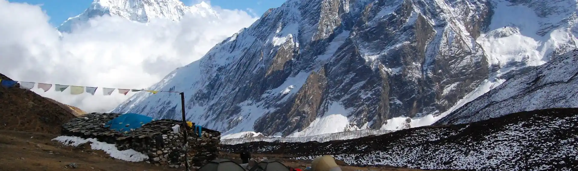
Berg Manaslu
Hierdie trek sal jou naby die 8ste hoogste berg ter wêreld, Mount Manaslu, 8 163 meter. Met hierdie avontuur sal jy aan die voet van hierdie piek staan. Daarbenewens sal jy ook ander berge soos Annapurna, Ganesh Himal, Cheo Himal en Ngadi Chili sien.
Larkya La-pas
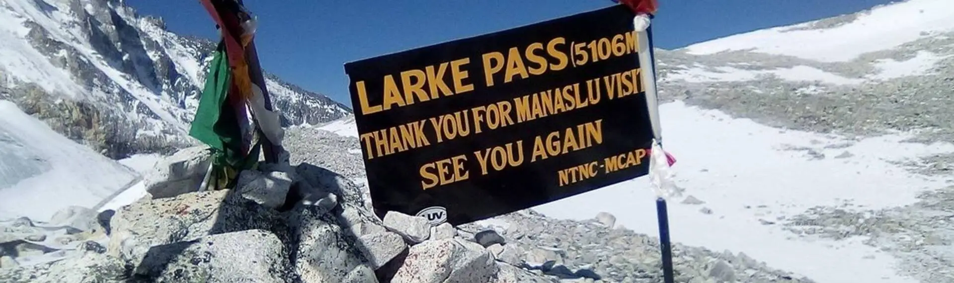
Die Larkhya La-pas, by 5 106 meter is die hoogste punt wat jy op hierdie reis sal bereikTerwyl jy daar staan, sal jy die panoramiese uitsigte oor die Himalajas aanskou. Dit word beskou as die langste pas in die Himalajas in Nepal, geleë tussen Dharmashala en Bimthang.
Manaslu-bewaringsgebied
Die staptog gaan deur die Manaslu-bewaringsgebied. Die gebied bied jou die kans om die diverse flora en fauna van die streek te aanskou. Jy kan wildspesies soos Rooipandas en Himalaja-Tahr sien. Dit is noodsaaklik om 'n Manaslu-bewaringsgebiedpermit te bekom, aangesien die staptog deur hierdie gebied gaan.
Tradisionele Dorpe en Kultuur
Jy sal deur dorpies soos Maccha Khola, Namrung, Samagaun, Samdo, Bhimtang en meer reis. Hierdie dorpies laat jou toe om die Tibetaans-geïnspireerde kultuur en tradisies van die mense te aanskou. Die mense hier is vriendelik en bied jou warm en verwelkomende gasvryheid.
Hoe moeilik is Manaslu Circuit Trek?
In vergelyking met ander staptogte in Nepal, is die Manaslu Circuit Trek 'n matigely uitdagend avontuur in die Himalajas. Die afgeleë van die trek en die hoë hoogte bied talle uitdagings vir die stappersOm die staptog te voltooi, vereis dit goeie fisieke fiksheid, aangesien jy ure lank deur steil opdraande en afdraande roetes sal moet stap. Die roete sluit rowwe paadjies, rivierkruisings en af en toe grondverskuiwings in, wat fokus en versigtige stappe vereis.
Die uitdagende Larkya La-pas, wat 5160 meter hoog is, val ook langs die roete. Hierdie gedeelte is die moeilikste deel van die roete as gevolg van die dun lug en koue temperature. Geleidelike akklimatisering en behoorlike voorbereiding maak die staptog egter hanteerbaar vir die meeste stappers. Ten spyte van die probleme, maak die staptog elke poging die moeite werd, met pragtige berguitsigte en ryk kulturele ervarings.
Harde Gedagtes
Jy moet die Manaslu Circuit Trek-kaart nagaan voordat jy met die avontuur begin. Dit verseker dat jy goed ingelig is oor die gebiede en ook 'n idee het van die probleme wat jy tydens die reis sal teëkom. Dit help jou om voor te berei vir die uitdagings, wat 'n veilige en aangename stapervaring in die Manaslu-streek bied. In hierdie trek sal jy nie net die natuurlike skoonheid van die Himalajas aanskou nie, maar ook die kans kry om jouself in die mense se unieke kultuur te verdiep.
Vrae & Antwoorde
Is die Manaslu-kring moeiliker as die Annapurna-kringtrek?
Die Manaslu Circuit Trek is oor die algemeen meer kompleks as die Annapurna Circuit Trek. Die roetes is meer afgeleë, ruig en minder ontwikkel, met beperkte geriewe in vergelyking met Annapurna. Die Larkya La-pas, op 5 106 meter, is ook meer uitdagend as die Thorong La-pas in terme van terrein en hoogte.
Hoe lank is die Manaslu Circuit-staptog?
Die Manaslu Circuit-staptog neem gewoonlik 12 tot 14 dae om te voltooi. Die totale afstand wat afgelê word, is ongeveer 177 kilometer (110 myl), afhangende van die roete wat geneem word. Die duur sluit 'n dag of twee van akklimatiseringsdae in dorpies soos Samagaon of Samdo in.
Watter permitte word benodig vir die Manaslu Circuit Trek?
Vir die Manaslu Circuit Trek benodig jy drie permitte: die Manaslu Restricted Area Permit (MRAP), die Manaslu Conservation Area Permit (MCAP), en die Annapurna Conservation Area Permit (ACAP). Hierdie permitte verseker verantwoordelike reis in die Manaslu-streek.
Wat is die beste tyd om die Manaslu Circuit Trek te doen?
Die beste tyd om die Manaslu-kring te stap is lente (Maart tot Mei) en herfs (September tot November). Hierdie seisoene bied stabiele weer, helder berguitsigte en gemaklike staptoestande. Winter- en moesonstaptogte is moontlik, maar dit kom met uitdagings soos sneeu en reën.
Is daar verblyf beskikbaar langs die Manaslu Circuit Trek?
Ja, teehuise en lodges is langs die roete beskikbaar, wat basiese maaltye en verblyf verskaf. Die geriewe is eenvoudiger en meer beperk as dié op die Annapurna-kring. Jy sal gedurende piekseisoene vooraf moet bespreek om 'n plek te kry om te bly.