14 Masiku
Mfundo Zowonjezera
Mayendedwe apansi ku Nepal
Mahotela ndi malo ogona a tiyi
Zakudya zonse kupatula ku Kathmandu
Ulendo wotsogozedwa ndi kuyenda ulendo wonse
Nthawi Yophukira, Masika
Wongolerani
Nepal
5,416 mamita
Kathamndu - Dharapani - Throngla Pass - Pokhara - Kathamndu


Nchifukwa chiyani ulendo wa masiku 14 ku Annapurna Circuit?
- Onani kusintha kuchokera ku nkhalango zotentha kupita ku chipululu cham'mwamba kwambiri pamene mukuzungulira Annapurna Massif
- Woloka phiri lotchuka la Thorong La Pass (5,416 m), limodzi mwa mapiri okwera kwambiri padziko lonse lapansi
- Pitani ku Muktinath Temple, malo ofunikira oyendera alendo kwa Ahindu ndi Abuda, odziwika ndi mapopu ake 108 amadzi.
- Pitani kumidzi yachikhalidwe ya Gurung ndi Thakali monga Manang, Pisang, ndi Yak Kharka
- Yendani m'mbali mwa mitsinje ya Marsyangdi ndi Kali Gandaki, kudutsa m'chigwa chakuya kwambiri padziko lonse lapansi - Kali Gandaki Gorge (5,571 m)
- Sangalalani ndi zakudya zakomweko monga Thakali Khana Set ndi pie ya apulo kumudzi wa Marpha, komwe kumadziwika kuti "Likulu la Apple ku Nepal."
- Jambulani mawonekedwe okongola a Annapurna I, Dhaulagiri, Manaslu, ndi Machhapuchhre (Fishtail) paulendo wonse.
- Sangalalani ndi kasupe wachilengedwe wotentha ku Tatopani.

Ulendo Wachidule
Lowani m'dziko lomwe kutembenukira kulikonse kwa njira kumavumbula malo atsopano oti mupiteko - takulandirani ku Ulendo wa Annapurna CircuitNjira yakale iyi ya ku Himalaya imazungulira phiri la Annapurna, imadutsa imodzi mwa mapasi apamwamba kwambiri padziko lonse lapansi, ndipo imagwirizanitsa zigwa zobiriwira ku zipululu za m'mapiri oumaNdi ulendo wa makilomita 160-230 wodzaza ndi zovuta, maulendo, ndi mphotho.
Ulendowu umayamba akafika ku Kathmandu ndipo umadutsa Dharapani, Chamendipo NthochiMukupitiriza kutero Manang, Yak Kharkandipo Thorong Phedi ndisanawoloke kupita Muktinath. Kenako tsikirani ku Tatopani, Ghorepani, ndi Phiri la Poon, kutha mu Pokhara ndi kubwerera ku Kathmandu.
Inu mudzawona Annapurna I, II, III, ndi IV, dhaulagiri (8,167 m) ndi Machhapuchre (6,993 m) mapiri patali. Njirayi imadutsa mitsinje ya Marsyangdi ndi Kali Gandaki ndipo imadutsa mapiri okwera Thorong La PassMidzi monga Manang ndi Marpha imasonyeza moyo wa m'mapiri momwe ulili weniweni.
Anthu am'deralo m'derali amasangalala ndi moyo wawo watsiku ndi tsiku wokhala ndi mphamvu. Gurung, Thakali, ndi Manangi madera amasunga miyambo yakale. Zikondwerero monga Lhosar (Disembala, Januwale, Febuluwale), Dashain (Seputembala-Okutobala), ndi Tihar (October-November) zili ndi mitundu yosiyanasiyana, nyimbo, ndi chisangalalo.
Mudzayenda mkati mwa Malo osungirako zachilengedwe a Annapurna paulendo uwu. Malo osungira zachilengedwe awa amateteza nyama zakuthengo monga nkhosa zabuluu, mbalame za ku Himalaya, mbalame za ku Langur, ndi mbalame zambiriNkhalango zimasintha kuchoka pa paini ndi oak kupita ku juniper ndi rhododendron pamene mukupita pamwamba. Ndi limodzi mwa madera olemera kwambiri okhala ndi zamoyo zosiyanasiyana ku Nepal.
M'zaka zaposachedwapa, kukula kwa misewu kwafika m'madera ena a derali. Tsopano mutha kufika ku Manang kuyambira pachiyambi, komanso kuchokera ku Muktinath kupita ku Jomsom ndi kupitirira apo, mbali ina ya msewu. Komabe, timatsatira njira yakale yachikhalidwe kuti tipite kutali kwambiri. Mtsinje wa Thorong La Pass umatsegulidwa kwa miyezi yambiri kupatulapo chipale chofewa chambiri m'nyengo yozizira. Ulendowu umakopa anthu pafupifupi 20,000 chaka chilichonse, zomwe zimathandiza kuti ukhalebe wokongola kwamuyaya.
Kodi Annapurna Circuit ndi yoyenera kwa inu?
Musanapite ku ulendowu, ndikofunikira kudziwa ngati ukugwirizana ndi kalembedwe kanu ka ulendo, mulingo wanu wolimbitsa thupi, komanso zomwe mukuyembekezera. Vuto ndilakuti zapakati mpaka zovuta za ulendo uwu. Dera la Annapurna limafuna mphamvu komanso kudziletsa. Mudzachita kuyenda maola 6-7 patsiku pamapiri otsetsereka, njira za miyala, ndi mapiri osinthasintha. Malo okwera kwambiri, Thorong La Pass, amayesa kupirira ndi kuleza mtima. Kawirikawiri, oyenda pansi kutentha pafupifupi 2,000-3,000 calories patsiku, kotero sitepe iliyonse imamveka ngati yopambana. Ulendo uwu ndi wa iwo omwe amasangalala ndi khama komanso mphotho.
Mabanja amaona kuti ndi ulendo wogwirizana, kugawana nkhani za nyumba ya tiyi pansi pa nyenyezi. Anthu oyenda okha amakumana ndi anzawo ochokera padziko lonse lapansi, ndipo ngakhale mabanja omwe ali ndi ana akuluakulu amatha kulowa nawo ngati akukonzekera. Tsiku lililonse limatenga mphamvu zanu, koma mawonekedwe amakubwezerani kakhumi. Chipale chofewa chimaoneka ngati Manaslu (8,163 m) Gangapurna (7,455 m) Tilicho Peak (7,134 m) Lamjung Himal (6,983 m) Ndiligiri (7,061 m), ndi mitsinje ngati Mtsinje wa Marsyangdi (150KM) ndi Kali Gandaki River (204KM) ikutsogolerani pakati pa mapiri a Himalaya.
Masiku 14 Annapurna Circuit Trek Ulendo
Tsiku 01: Kufika ku Kathmandu
Ulendo wanu wopita ku Annapurna Circuit umayambira ku Kathmandu (1,400 m), likulu la Nepal. Ndegeyo imatsika kuchokera kumapiri obiriwira a Chigwa cha Kathmandu, ozunguliridwa ndi Langtang Lirung (7,227 m). Mukafika ku Tribhuvan International Airport (TIA), woimira bungwe lathu loyendera adzakumana nanu ndikukusamutsani ku hotelo.
Ku hoteloyi, mudzakumana ndi wokutsogolerani wanu ndi bungwe loyendetsa maulendo oyenda pansi kuti mukambirane za ulendo wanu, kukambirana za njira zotetezera, ndikufunsani mafunso omaliza omwe mungakhale nawo. Tidzakuthandizaninso ndi zilolezo, monga Annapurna Conservation Area Permit (ACAP) ndi khadi la Trekkers' Information Management System (TIMS). Ngati mukufuna kusamalira zilolezo nokha, Ofesi ya Nepal Tourism Board ili ku Kathmandu, Bhrikuti Mandap.
Hotel
1,400 m / 4,593 ft
Tsiku 02: Yendetsani kuchokera ku Kathmandu kupita ku Dharapani
Tsiku limayamba m'mawa kwambiri ndi galimoto kuchokera ku Kathmandu kupita ku Dharapani. Njirayo imatsatira Mtsinje wa Trishuli, kenako imalumikizana ndi Mtsinje wa Marsyangdi, womwe umayenda kuchokera kudera la Manang. Gawo loyamba la ulendowu limakutengerani kumadzulo kuchokera ku Kathmandu ndi basi kudzera mu msewu waukulu wa Prithvi. Gawoli la ulendowu ndi losavuta, ngakhale kuti magalimoto amatha kukhala ambiri mukachoka ku Chigwa cha Kathmandu.
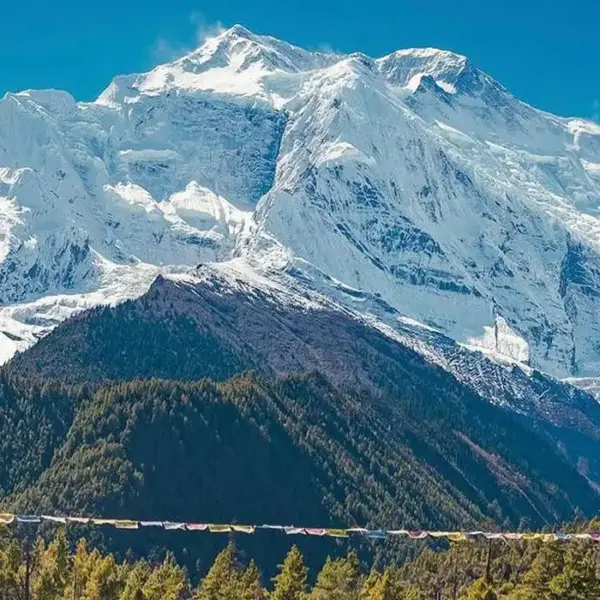
Mukayenda ulendo wautali, mudzadutsa m'matauni monga Besisahar, njira yachikhalidwe yopitira ku malo ambiri oyendera. Chigawo cha Annapurna maulendoKuchokera apa, msewu umachepa ndikukwera ku Chigwa cha Marsyangdi. Mutha kuwona mathithi ndi Lamjung Himal (6,983 m) panthawi yokwera iyi.
Mudzadutsa midzi ya Syange (1,100 m) ndi Jagat (1,300 m) musanafike ku Dharapani. Dharapani ndi mudzi wawung'ono wozunguliridwa ndi nkhalango za paini ndi nyumba zamwala zachikhalidwe. Mudzalowa m'nyumba yogulitsira tiyi usiku wonse ndikukonzekera ulendo wa tsiku lotsatira.
Chakudya cham'mawa, Chakudya chamasana, Chamadzulo
Nyumba ya tiyi
230 km pa
1,960 m / 6,430 ft
hours 8-10
Tsiku 03: Dharapani to Chame

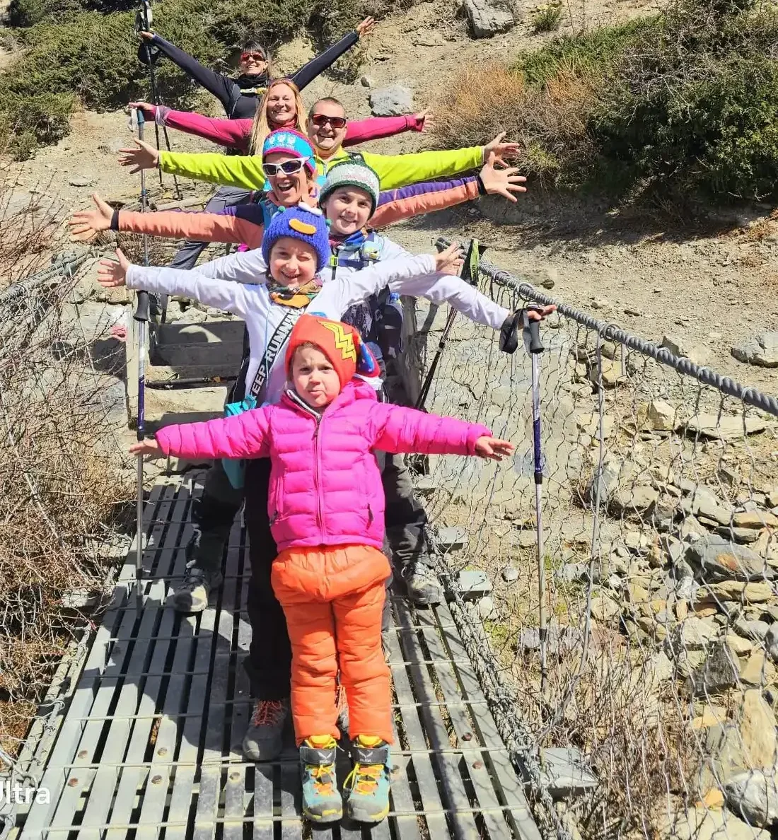
Ulendowu umayambira ku Dharapani (1,960 m) ndipo umatsatira Mtsinje wa Marsyangdi, womwe umadutsa m'chigwa cha Marsyangdi kwa pafupifupi makilomita 150. Njirayi imadutsa m'minda yokhala ndi mipanda yolimba komanso nkhalango za paini, ndipo imakutsatani bwino panjira. Njirayi ndi yokwera kwambiri, ndipo milatho yaying'ono imadutsa mitsinje ya Marsyangdi.
Mudzadutsa midzi ingapo yachikhalidwe monga Bagarchhap, Danakyu, Timang, ndi Koto panjira. Ku Timang, mutha kuyima kuti mudye nkhomaliro. Kuli malo okongola owonera Annapurna I ndi Mt.Manaslu. Anthu okhala m'mudzi nthawi zambiri amaoneka akunyamula zinthu kapena kutsogolera anthu oyenda panjira.
Pamene mukufika pamwamba ndikuyandikira Chame, malowo amakhala olimba pang'ono, ndipo mpweya umakhala wozizira. Mudzawona zizindikiro zambiri za chikhalidwe cha Chibuda cha ku Tibet, monga makoma a mani ndi mawilo opempherera. Tsiku limathera ku Chame, likulu la chigawo cha Manang. Pali malo ogona alendo omwe mungagone usiku wonse, komwe mungapumule ndikusangalala ndi chakudya chatsopano.
Chakudya cham'mawa, Chakudya chamasana, Chamadzulo
Nyumba ya tiyi
15 km pa
2,670 m / 8,760 ft
hours 5-6
Tsiku 04: Chame to Pisang
Njira lero ikutengerani ku nkhalango yowirira ya paini ndi rhododendron kutali ndi msewu wa jeep. Nsonga zakutali monga Pisang Peak (6,091 m) ndi Chulu East (6,584 m) zikuwonekera m'mbali mwa msewu. Mudzadutsa Bhratang (2,850 m), mudzi wokhala ndi famu ya maapulo ndi cafe, kenako Dhikur Pokhari (3,060 m), komwe chigwacho chimayamba kutseguka.
Pofika masana, mudzafika ku Pisang (3,200 m), mudzi womwe uli pansi pa Pisang Peak. Pisang yagawika m'magawo awiri akuluakulu: Lower Pisang (3,200 m) ndi Upper Pisang (3,300 m), ndipo mwina mungakhale ku Upper Pisang. Upper Pisang ili pamwamba pa mudzi wapansi, womwe umakhudzidwa ndi Tibet. Mwina imapereka mawonekedwe abwino kwambiri a mapiri a Annapurna ndi Pisang Peak.
Chakudya cham'mawa, Chakudya chamasana, Chamadzulo
Nyumba ya tiyi
14 km pa
3,200 m / 10,499 ft
hours 5-6
Tsiku 05: Pisang to Manang
Paulendo wa tsiku lino, pali njira ziwiri zopita ku Manang. Choyamba, njira yotsika (yosavuta komanso yachangu), ndipo chachiwiri, njira yokwera kudzera ku Ghyaru ndi Ngawal (yomwe ikulangizidwa). Anthu ambiri oyenda pansi ndi otsogolera amalimbikitsa kwambiri kutenga njira yokwera chifukwa cha malo ake okongola, chidziwitso chambiri cha chikhalidwe, komanso ubwino wokwera phiri kuti uzolowere. Tiyeni tikambirane zonsezi mwachidule.
Njira ya Lower imatsatira msewu wa fumbi wa jeep, ndipo ndi yosalala, yachangu, komanso ili ndi mapiri ochepa. Siimafuna mphamvu zambiri, siikongola kwambiri, ili ndi magalimoto ambiri, ndipo imapereka zochitika zochepa zachikhalidwe zakumidzi.
Njira Yaikulu imakwera kutali ndi mtsinje ndi msewu, kukudutsani m'midzi yakale yachikhalidwe cha ku Tibet. Kuchokera munjira iyi, mutha kuwona Annapurna II, Annapurna III, Annapurna IV, Gangapurna, ndi Tilicho Peak pafupi komanso momveka bwino. Midzi yomangidwa ndi miyala monga Ghyaru (3,730 m) ndi Ngawal (3,680 m) imapereka chithunzithunzi cha chikhalidwe chachikhalidwe cha Bhotiya.
Mulimonse momwe zingakhalire, mudzafika ku Manang madzulo. Pali malo ogona ndi malo ogulitsira tiyi omwe mungagone usiku wonse. Inu ndi ena onse mudzazolowera kuno musanawoloke Thorong La Pass.
Chakudya cham'mawa, Chakudya chamasana, Chamadzulo
Nyumba ya tiyi
20 km pa
3,540 m / 11,614 ft
hours 6-7
Tsiku 06: Tsiku Lozolowera ku Manang
Lero ndi tsiku lopumula komanso kuzolowera ku Manang. Lamulo lapamwamba lokwera mapiri okwera ndi "kukwera pamwamba, kugona pansi". Izi zikutanthauza kuti muyenera kuthera tsiku lanu mukuyenda m'mapiri okwera kuti muyese thupi lanu, kenako mubwerere kumapiri otsika a Manang kuti mukagone.
Pali njira zingapo zoyendera tsiku limodzi kuzungulira Manang. Choyamba ndi kuyenda kupita ku malo owonera pamwamba pa Nyanja ya Gangapurna. Ndi kosavuta kuyenda kupita ku malo owonera omwe akuyang'ana Nyanja ya Gangapurna yokongola komanso mapiri oundana. Iyi ndi njira yabwino kwa iwo omwe amamva kukwera kwambiri.
Kachiwiri, mutha kukwera phiri kupita ku Himalayan Rescue Association (HRA) Clinic viewpoint. Chipatala cha HRA chimachita zokambirana za tsiku ndi tsiku (nthawi zambiri nthawi ya 3 koloko masana) zokhudza kupewa ndi kuchiza matenda okwera. Kukwera phiri kupita ku chipatala kumapereka malingaliro abwino komanso chidziwitso chofunikira chachipatala. Kupezekapo pankhaniyi ndikofunikira kwambiri.
Tsikuli limaperekanso nthawi yoyendera mudzi wa Manang, nyumba yake ya amonke ya Braga, makoma a mani, ndi nyumba za miyala. Masitolo ndi malo ogona am'deralo amapereka chakudya ndi zinthu zina. Apa mutha kupuma, kunyowetsa madzi, ndikukonzekera kukwera ku Yak Kharka ndipo, pamapeto pake, Thorong La Pass.
Chakudya cham'mawa, Chakudya chamasana, Chamadzulo
Nyumba ya tiyi
3,540 m / 11,614 ft
Tsiku 07: Manang kupita ku Yak Kharka
Pa tsikuli, njirayo imachoka ku Manang ndipo imapitirira kumpoto kupita ku chigwa cha Marsyangdi. Mitsinje yaying'ono imadutsa m'mbali mwa njirayo, ndipo mpweya umachepa mukakwera pamwamba. Nsonga monga Annapurna III (7,555 m) ndi Gangapurna (7,455 m) zimakutsatirani ulendo wonse. Mudzadutsa midzi yaying'ono monga Gunsang (3,930 m), yomwe nthawi zambiri imakhala ndi malo ochepa ophikira tiyi ndi malo odyetserako ziweto. Mawonekedwe a Tilicho Peak amawonekera pamene njirayo ikutsatira njira ya pamwamba pa mtsinjewo.
Masana, mudzafika ku Yak Kharka. Malo ozungulira malowa ndi okhala ndi magulu a mbalame za yak ndi nkhosa zabuluu. Mudzagona usiku wonse kuno m'nyumba yophikira tiyi. Zinthu zofunika pano ndizosavuta kuposa ku Manang, koma zokwanira kuti munthu apumule bwino usiku.
ZindikiraniM'malo mopita mwachindunji ku Yak Kharka, mutha kupita kumudzi wa Khangsar ndikupitilira ku chigwa kupita ku Tilicho Base Camp. Izi zikutsogolerani ku njira yokongola yolowera ku Nyanja ya Tilicho.
hours 4-5
Nyumba ya tiyi
12 km pa
4,050 m / 13,287 ft
Chakudya cham'mawa, Chakudya chamasana, Chamadzulo
Tsiku 08: To Thorang Phedi to Yak Kharka
Tsiku lachisanu ndi chitatu ndi ulendo wovuta koma waufupi womwe umakufikitsani pansi pa Thorong La Pass. Njirayo imatsatira njira ya pamwamba ya Mtsinje wa Marsyangdi, ndikuwoloka milatho yamatabwa kudutsa mitsinje yamadzi oundana. Chulu West (6,419 m) ndi Chulu East (6,584 m) khalani owonekera nthawi yonse yoyenda.
Mukakwera phiri lalifupi, mudzadutsa ku Ledar (mamita 4,200). Mudzadutsa malo angapo otsetsereka ndi madera omwe matope amatha kugwa. Gawoli limafuna kusamala komanso kuyang'anitsitsa, koma njirayo ndi yolemetsa komanso yosavuta kuisamalira. Nkhosa za Yaks ndi buluu nthawi zambiri zimaoneka zikudya m'minda. Pakati pa masana, mudzafika ku Thorong Phedi, msasa wa asilikali musanadutse Thorong La Pass.
Chakudya cham'mawa, Chakudya chamasana, Chamadzulo
Nyumba ya tiyi
7 km pa
4,540 m / 14,895 ft
hours 3-4
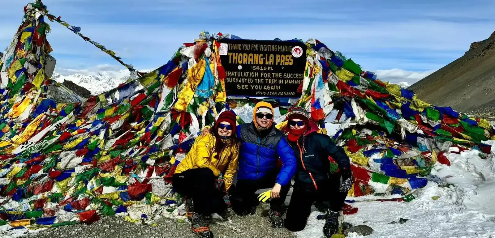
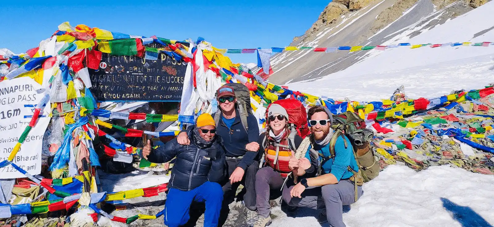
Tsiku 09: Thorong Phedi kupita ku Thorong La Pass kupita ku Muktinath

Mudzayamba tsiku lanu molawirira kwambiri (pafupifupi 4:00 AM ndi 5:00 AM) kuti muwoloke msewu wa mtsinje usanayambe mphepo yamphamvu ya masana komanso pamene chipale chofewa chidakali cholimba. Mudzawoloka mitsinje yozizira ndi malo otsetsereka a miyala musanafike ku Thorong La Pass (5,416 m), malo okwera kwambiri paulendo wa Annapurna Circuit. Nsonga za mapiri ngati Pamwamba pa Thorong (6,144 m), Yakawa Kang (6,482 m), ndi Khatung Kang (6,484 m) zitha kuwoneka mozungulira msewu.
Mapiri a Himalaya monga Annapurna ndi Dhaulagiri ndi omwe amaonekera bwino kuchokera pamwamba pa phirilo. Mbendera zopempherera zimaphimba chikwangwani cha phirilo, zomwe zimasonyeza kupambana kwakukulu kwa woyenda pansi aliyense. Mukakhala pamwamba pa phirilo kwa kanthawi, mudzatsika kupita ku Muktinath, malo opatulika kwa Ahindu ndi Abuda.
Kachisi wa Muktinath, wokhala ndi mipope yamadzi 108 ndi lawi lamoto wosatha, uli pakati pa mudziwo. Tsikulo limatha ndi mpumulo chifukwa kukwera kovuta kwambiri kwa ulendowo kwatha.
Chakudya cham'mawa, Chakudya chamasana, Chamadzulo
Nyumba ya tiyi
20 km pa
3,800 m / 12,467 ft
hours 10-12
Tsiku 10: Ulendo kapena Kuyendetsa Galimoto kuchokera ku Muktinath kupita ku Tatopani
Ulendo wochokera ku Muktinath kupita ku Tatopani umaphatikizapo kutsika phiri lalikulu kudzera mu chigwa cha Kali Gandaki. Chifukwa cha kumangidwa kwa misewu, gawoli tsopano limagwiritsidwa ntchito ndi jeep kapena basi yakomweko, koma anthu odziwa bwino ntchito yoyenda amatha kupeza njira zina zoyendamo zomwe zimapewa msewu waukulu komanso wafumbi.
Mudzadutsa Kagbeni (2,804 m) ndi Jomsom (2,720 m). Jomsom ndi likulu la chigawo cha Mustang ndipo ili ndi bwalo la ndege lomwe lili ndi maulendo a ndege opita ku Pokhara tsiku lililonse. Nilgiri Himal (7,061 m) imakwera kum'mawa, ndipo minda ya zipatso za maapulo imapezeka ku Marpha konse (2,670 m), komwe kumadziwika ndi brandy yake ya maapulo ndi chikhalidwe cha Thalaki. Njirayi ikupitirira kudutsa Ghasa (2,010 m) pamene malo ake akukhala obiriwira.
Masana, mudzafika ku Tatopani, kutanthauza "madzi otentha" mu Chinepali. Mudziwu umadziwika ndi akasupe ake achilengedwe otentha pafupi ndi mtsinje wa Kali Gandaki. Mudzapumula kuno mutatsika nthawi yayitali, mukulowa m'madzi ofunda. Ndi malo abwino opumulira musanakwerenso ku Ghorepani.
Chakudya cham'mawa, Chakudya chamasana, Chamadzulo
Nyumba ya tiyi
110 km (ngati mukuyendetsa galimoto) / 35 km (ngati mukukwera mapiri)
1,190 m / 3,904 ft
hours 6-8
Tsiku 11: Tatopani to Ghorepani

Tsiku limayamba pochoka ku kasupe wotentha wa Tatopani ndikuwoloka mlatho wopachikika pamwamba pa Mtsinje wa Kali Gandaki. Pambuyo pake, mudzadutsa midzi ingapo yachikhalidwe ya Magar ndi Gurung monga Sikha (1,935 m) ndi Chitre (2,930 m). Njirayo imadutsa nkhalango za oak ndi rhododendron zomwe zimamera maluwa ofiira ndi pinki nthawi ya masika. Nsonga za Annapurna South (7,219 m) ndi Dhaulagiri (8,167 m) zimawonekera kuchokera ku phiri lotseguka m'njira.
Masana, mudzafika ku Ghorepani, malo otchuka oimikapo magalimoto. Mudziwu uli pansi pa Poon Hill ndipo uli ndi nkhalango yowirira. Uli ndi malo ambiri ogona tiyi ndi malo ogona omwe amapereka malo abwino okhala ndi Wi-Fi ndi shawa yotentha pamtengo wotsika pang'ono.
Chakudya cham'mawa, Chakudya chamasana, Chamadzulo
Nyumba ya tiyi
35 km pa
2,860 m / 9,383 ft
hours 7-8
Tsiku 12: Pokhara kupita ku Ghorepani kupita ku Poon Hill
Tidzadzuka m'mawa kwambiri (pafupifupi 4:00 AM -4:30 AM) kuti tiyambe ulendo woyenda mumdima kuti tifike pamalo owonera dzuwa lisanatuluke. Kuchokera pamwamba, malo owonera ambiri akutseguka ku Dhaulagiri I (8,167m), Annapurna I (8,091m), Annapurna South, Nilgiri, Machhapuchhre (Nsonga ya Fishtail), ndi Nsonga ya Tukuche. Kutuluka kwa dzuwa kumasandutsa mapiri agolide pamene mitambo ikuyenda kudutsa chigwa cha Kali Gandaki chomwe chili pansi pake.
Mukatha kusangalala ndi malo okongola ndi kujambula zithunzi, mudzabwerera ku Ghorepani kukadya chakudya cham'mawa ndikuyamba kutsika kupita ku Banthanti (2,210 m). Njirayi ili ndi masitepe ambiri a miyala, omwe amatha kukhala ovuta pa mawondo. Midzi monga Ulleri (2,050 m) ndi Hile (1,430 m) imawonekera panjira, ndipo minda ya mpunga ndi mapira imafalikira ponseponse.
Masana, mudzafika ku Nayapul (1,070 m), komwe ulendowu umathera. Kuchokera apa, ulendo wa maola 6-7 umakutengerani ku Pokhara (827 m), mzinda womwe uli pafupi ndi Nyanja ya Phewa. Mutha kulowa mu hotelo yanu ndikusangalala ndi kupuma mokwanira, kusamba ndi madzi ofunda, komanso kudya chakudya chopatsa thanzi. Ngati nthawi ilola, mutha kupita ku Nyanja ya Phewa, kupita ku Kachisi wa Tal Barahi, kusangalala ndi dera lomwe lili m'mphepete mwa nyanja, ndikuwona mapanga monga Mahendra ndi Bat Cave.
Chakudya cham'mawa, Chakudya chamasana, Chamadzulo
Nyumba ya tiyi
50 km pa
822 m / 2,697 ft
hours 1-2
Tsiku 13: Yendetsani kuchokera ku Pokhara kupita ku Kathmandu
Tsikuli ndi lokongola koma mwina ndi ulendo wautali wobwerera kuchokera ku Pokhara kupita ku Kathmandu pa Prithvi Highway, zomwe zikutanthauza gawo lomaliza la ulendo wopita ku Annapurna Circuit. Ulendowu umayenda m'mbali mwa Mtsinje wa Seti poyamba, womwe umayenda kuchokera kudera la Annapurna, kenako umalowa mu Mtsinje wa Trishuli, womwe umadziwika ndi njira zake zamphamvu zoyendera mafunde komanso zokwera pamahatchi.
Ulendowu umadutsa m'matauni a m'mapiri monga Damauli, Muglin, ndi Malekhu ndipo umaona malo oimikapo magalimoto ndi misika yakomweko. Pambuyo pa maola 6-7, mudzafika ku Kathmandu Valley, yozunguliridwa ndi mapiri a Shivapuri ndi Phulchowki.
ZindikiraniKwa iwo omwe ali ndi nthawi yochepa kapena omwe sakufuna kuyenda ulendo wautali, pali ulendo wa mphindi 25 kuchokera ku Pokhara kupita ku Kathmandu.
Chakudya cham'mawa, Chakudya chamasana, Chamadzulo
Hotel
200 km pa
1,400 m / 4,593 ft
hours 6-8
Tsiku 14: Kunyamuka Komaliza
Ulendo wanu wa ku Annapurna Circuit watha lero. Mutatha kudya chakudya cham'mawa, nthawi yakwana yoti munyamule katundu wanu ndikupita ku Tribhuvan International Airport kuti mukanyamuke komaliza. Kutengera ndi nthawi yanu yandege, mungakhale ndi nthawi yoyenda pafupi ndi hotelo yanu kuti mugule zikumbutso zilizonse kapena zinthu zaluso zakomweko.
Tikonza zoti tikwere taxi kapena tikwere pasadakhale ulendo wopita ku TIA. Magalimoto ku Kathmandu ndi osadalirika, kotero tidzachoka ndi nthawi yokwanira (osachepera maola 3-4 ndege isananyamuke). Ulendowu ukhoza kukhala utatha, koma mzimu wa dera la Annapurna—njira zake, midzi, ndi mapiri ake umakhalabe ndi inu nthawi yayitali mutabwerera kunyumba.
Chakumwa
1,400 m / 4,593 ft
Mapu a Ulendo wa Masiku 14 ku Annapurna Circuit
Zoyenera Kuyembekezera?
Zomwe Zimaphatikizidwa
- Kutenga ndi kusiya ndege/hotelo pagalimoto yachinsinsi.
- Hotelo yausiku umodzi ku Kathmandu ndi hotelo yausiku umodzi ku Pokhara yokhala ndi dongosolo la malo ogona ndi chakudya cham'mawa
- Chakudya chonse (cham'mawa, chamasana, ndi chamadzulo) panthawi yonse yoyenda
- Tsatanetsatane wa mayendedwe:
Kuchokera ku Kathmandu kupita ku Dharapani ndi basi yakomweko, ndipo kuchokera ku Pokhara kupita ku Kathmandu ndi basi ya alendo.
Ngati mukufuna jeep kapena ndege, mukhoza kukonza zimenezo ngati mutapempha pamtengo wowonjezera:
Kathmandu to Dharapani ndi jeep: USD 250
Ndege kuchokera ku Pokhara kupita ku Kathmandu: USD 106
Kuchokera ku Pokhara kupita ku Kathmandu ndi galimoto: USD 150
Kuchokera ku Pokhara kupita ku Kathmandu ndi jeep: USD 250
- Mapu oyenda
- Buku lotsogolera la anthu odziwa bwino ntchito omwe ali ndi ziphaso za boma
- Wonyamula katundu woyenda panyanja/Sherpa amene adzakunyamulirani matumba anu paulendo. (Anthu awiri pa wonyamula katundu m'modzi)
- Inshuwalansi, malipiro, zida, mayendedwe, ndi msonkho wakomweko kwa wotsogolera.
- Zipangizo zachipatala zamagulu (zidzakhalapo ndi zida zothandizira oyamba)
- Mapepala onse ofunikira ndi zilolezo zolowera m'mapaki a dziko
- Makonzedwe oyendera ndi opulumutsa
- TIMS (Trekkers' Information Management System)
- Misonkho yonse ya boma ndi ndalama zothandizira alendo
Zomwe Zachotsedwa
- Chakudya ku Kathmandu musanayambe ulendo woyenda pansi komanso mutapita.
- Inshuwalansi yanu yaulendo (Kupulumutsa)
- Malangizo kwa ogwira ntchito paulendo ndi oyendetsa
- Zakumwa (zotentha, zozizira, ndi zakumwa zoledzeretsa)
- Kugula zinthu ndi kuchapa zovala, ndi zina zotero
- Zida zoyendera munthu.
Ndemanga za Tripadvisor
Zotsatira za Google
Ulendo Wowonjezera wa Masiku 14 wa Annapurna Circuit
Ulendo wa Masiku 14 ku Annapurna Circuit
Njira ya Annapurna Circuit ikuphatikizapo kuyendetsa galimoto kumayambiriro ndi kumapeto kwa ulendo kuti izi zitheke munthawi yochepaUlendo umayamba ndi galimoto kuchokera ku Kathmandu kupita ku Dharapani kudzera ku Besisahar, komwe msewu wakonzedwa mpaka ku Besisahar koma amakhala msewu wodzaza ndi mikwingwirima komanso wopanda magalimoto pamene mukukwera ku Dharapani. Kuchokera ku Dharapani kupita ku Chame ndi Pisang, njirayo imakhala yokongola kwambiri koma ya miyala, yokhala ndi zigawo za malo omwe amakhudzidwa ndi kugwa kwa nthaka.
Njira yochokera ku Pisang kupita ku Manang imadutsa m'zigwa ndi m'mapiri. Misewu yalembedwa pang'ono apa, koma njira zoyendera pansi zalembedwa bwinoPopitirira mmwamba, njira yochokera ku Manang kupita ku Yak Kharka ndi udzu wa yak ndi zitsamba za juniper. Mpweya umachepa, ndipo malowo amakhala a miyala kwambiri. Kuchokera ku Yak Kharka kupita ku Thorong Phedi, njirayo ndi yopapatiza komanso yopapatiza, nthawi zambiri imakhala ndi fumbi, ndipo imatha kukhala yozizira kutengera nyengo..
Tsiku lovuta kwambiri ndi loti lidutse Thorong La Pass, komwe njirayo imakhala ya miyala ndipo imakutidwa ndi chipale chofewa kapena ayezi m'miyezi yozizira. Pambuyo pa njirayo, njirayo imatsikira ku Muktinath, kumene njirayo imakhala ya miyala koma yosavuta. Kuchokera ku Muktinath kupita ku Pokhara, njirayo imakhala yophimbidwa ndi nkhalango, ndipo misewu yokonzedwa imayambiranso mukangofika pafupi ndi Pokhara.
Tsiku Lachizolowezi mu Ulendo wa Masiku 14 wa Annapurna Circuit
Tsiku lachizolowezi pa Annapurna Circuit Trek ku Nepal limaphatikizapo chakudya cham'mawa kwambiri, kenako kuyenda masana, ndikufika ku malo otsatira ogulitsira tiyi madzulo kapena madzulo. Sangalalani ndi Nepal kumayamba ndi komwe mudzadyere chakudya chamadzulo ndikugona. Patsiku lachizolowezi, mutha kufufuza zinthu zambiri pa Annapurna Round Trek.
Tsiku limayamba molawirira ndi chakudya cham'mawa chokoma pakati pa 6:00 ndi 7:00 AM. Mukadzuka, mudzatsitsimuka kenako mukonzekere chakudya cham'mawa. Mukamaliza chakudya chanu cham'mawa, tsopano mwakonzeka ulendo wa m'mawa kwambiri. Ulendo wa m'mawa umayamba kuyambira 8 AM mpaka pafupifupi 12 PM mpaka 1 PM. Mukagona maola anayi kapena asanu, nthawi yakwana yoti mudye chakudya chamasana. Wotsogolera wanu adzakutengerani ku malo odyera omwe ali pafupi ndi dera lomwe mungadye nkhomaliro yanu ndikupuma pang'ono.
Mukadya nkhomaliro, nthawi yakwana yoti mupitirize ulendo wopita kumalo ena kapena nyumba ya tiyiDzuwa likayamba kulowa, chilengedwe chimakhala chozizira, kotero kufika kumudzi wanu wotsatira dzuwa lisanalowe ndikofunikira. Mudzafika kumudzi wotsatira madzulo a 5 mpaka 6 koloko madzulo Mukayenda pang'ono mumudzi, nthawi ya chakudya chamadzulo yakwana. Mudzadya chakudya chamadzulo m'nyumba yophikira tiyi, pafupifupi 8 mpaka 9 koloko madzulo. Mukadya chakudya chamadzulo, mutha kukhala maso pang'ono, koma musakhale maso mochedwa, chifukwa mumafunika kupuma mokwanira paulendo wotsatira. Chifukwa chake, ili ndi tsiku lachizolowezi mu Annapurna Circuit Trek.
Kukwera kwa Circuit ya Annapurna
The Zopereka za Annapurna Circuit Trek malo okwera osiyanasiyana. Ulendo wa Annapurna Circuit mtunda Ulendowu umayambira ku mudzi wawung'ono wa Besisahar pamtunda wa mamita 760. Dharapani pa 1800m ndipo Chame pa 2710m mpaka mutafika ku Upper Pisang pa 3,300m. Oyenda pansi amakwera kupita ku Ngawal pa 3,650 m asanatsike pang'ono kupita ku Manang pa 3540m. Kubwerera ku Manang kumatsatira kukwera phiri kuchokera ku Manang kupita ku Kincho Tal pa 4,620 metres.
Ulendowu ukupitirira mpaka ku Yak Kharka pa mamita 4,018 ndipo ku Thorong Phedi pa mamita 4,450. Gawo lovuta kwambiri ndi kukwera kuchokera ku Thorong Phedi ku ku Thorong La Pass, malo okwera kwambiri paulendowu omwe ali mamita 5,416, kenako kutsika kupita ku Ranipauwa pa mamita 3.965.
Location |
Kutalika (m) |
Kusintha kwa Kukwera (m) |
| Besisahar | 760 | - |
| Dharapani | 1800 | + 1040 |
| Chame | 2710 | + 910 |
| Upper Pisang | 3300 | + 590 |
| Ngawal | 3650 | + 350 |
| Manang | 3540 | -110 |
| Kincho Tal | 4620 | +1080 (kukwera kwa kusinthasintha kwa mlengalenga) |
| Yak Kharka | 4018 | -602 |
| Thorong Phedi | 4450 | + 432 |
| Thorong La Pass | 5416 | + 966 |
| Ranipauwa | 3965 | -1451 |
Malo Ogona ndi Chakudya ku Annapurna Circuit Trek
Ulendo wa ACT ndi umodzi mwa maulendo ovuta kwambiri ku Nepal, ndichifukwa chake zinthu monga Malo Ogona ndi Chakudya ndizofunikira. Mukakhala paulendo wautali komanso wovuta, muyenera kupuma usiku wonse mukakhala pamalo oyenera, ndipo muyenera kudya chakudya chokwanira chodzaza ndi michere, kotero kukonzekera zinthuzi ndikofunikira. Tiyeni tikambirane.
malawi
Ngakhale kuti derali lili kutali, Annapurna Trek imapereka malo osiyanasiyana ogona, kuyambira nyumba zogulira tiyi mpaka nyumba za alendo, kuyambira Besisahar mpaka Jomsom, zomwe zimapereka malo ogona abwino komanso abwino. Nyumba iliyonse yogulira tiyi imapereka bedi la anthu awiri okhala ndi malo okwanira. Mukakwera, malo ogona amakhala osavuta koma amakhala omasuka. Mashawa otentha, oyendetsedwa ndi mphamvu ya dzuwa amapezeka mpaka ku Manang pamtengo wotsika, zomwe ndizofunikira chifukwa cha kuzizira komanso malo okwera. Mutha kulipiritsa zida pamalo olandirira alendo pamtengo wotsika, koma chochapira cha dzuwa ndi njira yabwino kwambiri yogwiritsira ntchito kuwala kwa dzuwa kochuluka panjira.
Zakudya
Mukhozanso kukhala ndi malo ogulitsira zakudya m'malesitilanti kapena m'nyumba zomwe mudzakhalamo panthawi ya ulendo wanu wa ACT. Tsiku lililonse paulendo, oyenda pansi adzakhala ndi Chakudya Cham'mawa, Chakudya Chamadzulo, ndi Chakudya Chamadzulo. Chakudya cham'mawa ndi chakudya cham'mawa kwambiri, chomwe ndi chofunikira kwambiri. Pambuyo pa gawo loyamba la ulendo, oyenda pansi adzakhala ndi chakudya chamasana pafupifupi masana, ndipo madzulo, asanagone, oyenda pansi adzakhala ndi chakudya chawo chamadzulo. Nazi zina mwa njira zodyera chakudya cham'mawa, Chakudya Chamadzulo, ndi Chakudya Chamadzulo.
- Chakudya cham'mawa: Chotupa, Buledi, Mazira Ophika kapena Ma Omelet, Tiyi, Khofi, Chokoleti Yotentha, ndi Chimanga
- Chakudya chamasana ndi Chamadzulo: Local Dal Bhat, Ghundruk, Dhido, Pizzas, Burgers, Momos, Dumplings, Thukpa, Chowmein, Pasta, Macaroni, Spaghetti, ndi ena.
Ulendo wa Annapurna Circuit ndi Wovuta Kwambiri
The crux wa Annapurna Circuit Trek zovuta Zitha kusinthidwa mosavuta kudzera m'mfundo zotsatirazi:
- Zaka ndi Kulimbitsa ThupiUlendowu ndi woyenera kwambiri kwa anthu azaka zapakati pa 16 ndi 55. Ana osakwana zaka 12 ndi okalamba opitirira zaka 60 angapeze zovuta m'madera okwera ngati Thorong La Pass.
- Zovuta za AltitudeUlendowu umayamba pafupifupi mamita 1,000 ndikukwera mpaka mamita 5,416, komwe mpweya umachepa ndi pafupifupi 50%. Matenda a mtunda ndi vuto lalikulu pano.
- Matenda oyenera kuganiziraNgati ndinu wodwala matenda a mtima, mphumu, matenda osatha a m'mapapo, kapena kuthamanga kwa magazi, ndiye kuti mungakumane ndi mavuto aakulu opitirira mamita 3,500. Chifukwa chake, funsani dokotala musanayese kuyenda ulendowu.
- Kutalikirana ndi Kulumikizana KochepaMidzi yomwe ili pamwamba pa Manang ili ndi Wi-Fi yochepa kapena yopanda intaneti komanso ma siginecha ofooka a m'manja. Kulankhulana ndi abale, abwenzi, ndi achibale kumakhala kovuta kwa masiku angapo.
- Makhalidwe a NjiraMalo otsetsereka komanso otsetsereka pakati pa Chame ndi Pisang kapena pafupi ndi Thorong Phedi angakhale ovuta kwa oyamba kumene.
- Thandizo Lachipatala LochepaMalo azaumoyo amapezeka ku Manang ndi Muktinath kokha, pomwe madera ena amadalira thandizo loyamba. Pakagwa mwadzidzidzi, kupulumutsa anthu ndi helikopita ndiyo njira yokhayo, yomwe ingakhale yokwera mtengo.
Mankhwala Ochizira Matenda Okwera Pa Ulendo wa Annapurna Circuit
Kuzolowera Moyenera:
Njira imodzi yabwino kwambiri yothetsera matenda okwera ndi kuzolowera malo okwanira. Njira yoyenera yozolowera malo ndi kukweza malo okwera, kuyenda pang'onopang'ono pamalo okwera, kenako kutsika kukagona. Kuzolowera malo ndikofunikira kuti muzolowere nyengo, nyengo, komanso mpweya wochepa.
Kuthamanga:
Thupi lanu limafuna madzi okwanira kuti lichepetse kudwala kwa malo okwera. Mpweya umakhala wokwera kwambiri pamalo okwera, zomwe zimapangitsa kuti thupi liume ndikuchotsa madzi mwachangu. Chifukwa chake, tsiku lililonse, onetsetsani kuti mumamwa madzi kapena zakumwa zina monga tiyi ndi zakumwa zopatsa mphamvu, ndipo mutha kumwanso makapu angapo a khofi. Kusowa kwa madzi m'thupi lanu kudzayambitsa kudwala kwa malo okwera.
Mankhwala:
Njira ina yothetsera vuto la matenda a m'mapiri ndi kumwa mankhwala oyenera nthawi iliyonse mukamva zizindikiro za matenda a m'mapiri. Diamox, Nifedipine, ndi Dexamethasone Ndi mankhwala odziwika bwino omwe anthu oyenda pansi amagwiritsa ntchito akamayenda m'mapiri okwera. Choncho nthawi iliyonse mukavutika maganizo kapena mukuvutika ndi zizindikiro, mutha kumwa mankhwalawo kuti thupi lanu limve bwino.
Annapurna Circuit Trek Permit
Zilolezo zofunika paulendo wa Annapurna Circuit ndi izi: Mtengo wa ACAP (Chilolezo cha Malo Osungirako Zinthu ku Annapurna) ndi NTHAWIChilolezochi, chomwe chinayambitsidwa mu 1992, chimatsimikizira kuti kuteteza chigawochi ndi zamoyo zosiyanasiyanaMungapeze ku Kathmandu, Pokhara, kapena pamalo olowera ku Malo osungirako zachilengedwe a Annapurna Chilolezo chiyenera kunyamulidwa nthawi zonse paulendo.
- ACAP: USD 21.14 pa munthu aliyense kwa nzika zakunja ndi USD 7.05 kwa nzika za SAARC. Zofunikira kuti munthu alowe mu Annapurna Conservation Area.
- Khadi la TIMS: USD 21.14 pa munthu aliyense pa ulendo, USD 10 pa munthu aliyense pa magulu. Chofunika kwa alendo onse omwe akuyenda ku Nepal kuti atsatire chitetezo.
ZindikiraniNgati musungitsa phukusi kudzera mu Himalayan 360, tidzayang'anira zilolezo zanu zonse ndi zikalata zofunika kuchokera kwa ife.
Kodi n’chiyani chimapangitsa ulendo wa Annapurna Circuit Trek kukhala wapadera?
Ulendo wa Annapurna Circuit ndi malo apadera oyendera ku Nepal chifukwa cha kusiyana kwa malo ake, chikhalidwe cholemera, komanso mawonekedwe okongola a mapiri. Nazi zinthu zina zofunika zomwe zimapangitsa kuti ukhale wapadera.
Kachisi wa Jwala Mai ku Muktinath
Kachisi wa Jwala Mai ali pamalo kutalika kwa 3,800 mamita ku Muktinath, Mustang. Ndi malo opatulika kwambiri oyendera maulendo achipembedzo Ahindu ndi Abuda onse ku Nepal. Kachisiyu ndi wotchuka chifukwa cha moto wake wachilengedwe wosatha komanso Mapopopo amadzi 108 okhala ndi mutu wa ng'ombe zomwe zimathira madzi ozizira kuchokera mumtsinje wa Kali Gandaki. Ahindu amaona Muktinath ngati kwawo kwa Ambuye Vishnu, pomwe Abuda amalilemekeza ngati malo omwe adachezera Guru Rinpoche (Padmasambhava) m'zaka za m'ma 8. Alendo ambiri amapita kukaona malo opatulika kuti akatsuke karma ndi kufunafuna Moksha, kapena kuti kumasulidwa.
Nyumba ya Amonke ya Braga ndi Nyumba Yakale ya Mapanga ku Manang
Nyumba ya amonke ya Braga ili pa 2,845 mamita pamwamba pa mudzi wa Braga m'chigawo cha Manang. Kwatha Zaka 500 ndipo ndi oimodzi mwa nyumba zakale kwambiri za amonke zachi Buddha ku Annapurna CircuitNyumba ya amonke ili ndi zithunzi zakale zojambulidwa pakhoma, mawilo opempherera, ndi ziboliboli za Buddha ndi milungu yakomweko. Pafupi ndi nyumba zakale za m'mapanga zikusonyeza momwe anthu oyamba kukhala m'malo amenewa anazolowera nyengo zovuta kwambiri. Anthu ankakhala m'mapanga amenewa kuti atetezedwe ku chipale chofewa, mphepo yozizira, ndi zigumula. Nyumba ya amonke ndi mapanga pamodzi zimasonyeza moyo wachikhalidwe wa ku Himalaya ndi cholowa cha Buddhist.
Kusintha Kwambiri Gangapurna Glacier
Gangapurna Glacier ili pafupi ndi Manang at an kutalika kwa pafupifupi 3,500-4,000 m. Imadyetsa Nyanja ya Gangapurna, yomwe imasintha mtundu ndi kukula kutengera nyengo ndi kuchuluka kwa kusungunuka. Malo ake amasintha nthawi zonse chifukwa cha kusungunuka, chipale chofewa, ndi kuyenda. Derali ndi lofunika kwambiri pakupereka madzi m'deralo, ndipo limadyetsa mitsinje yomwe imathandizira midzi yomwe ili pansi pa mtsinje.
Kulowa kwa dzuwa ndi kutuluka kwa dzuwa pamwamba pa Dhaulagiri kuchokera ku Poon Hill
Poon Hill (3,210 m) ndi malo otchuka owonera Annapurna Circuit komwe mungathe kuwona bwino Dhaulagiri, Annapurna I, ndi Machhapuchhre. Oyenda m'maulendo amadzuka m'mawa kwambiri kuti akafike pamwamba pa dzuwa, pamene nsonga zake zimaunikiridwa ndi kuwala kwagolide. Madzulo, kulowa kwa dzuwa kumapaka phirilo ndi utoto wofiira ndi lalanje. Malo owonera awa ndi kufikako pambuyo poyenda pang'ono kuchokera ku Ghorepani, zomwe zimapangitsa kuti anthu ambiri oyenda pansi azitha kufikako mosavuta.
Kukonzekera ndi Maphunziro a Annapurna Circuit Trek
Kukonzekera bwino ndi maphunziro ndizofunikira kuti mumalize ulendo wa Annapurna Circuit mosamala komanso momasuka. Nazi zinthu zomwe muyenera kuzidziwa.
- Yendani, thamangani, kapena yendani njinga masiku 5-7 pa sabata kwa mphindi 45-60 kuti muwongolere mphamvu ya mtima ndi mapapo paulendo wautali wa tsiku ndi tsiku.
- Yang'anani kwambiri miyendo, pakati, ndi kumbuyo ndi squats, lunges, step-up, ndi masewera olimbitsa thupi olemera kuti muthane ndi njira zamiyala ndi matumba olemera.
- Ngati n'kotheka, yendani mapiri kapena khalani pamalo okwera kwambiri opitirira mamita 2,500 kuti thupi lanu lizolowere mpweya wochepa.
- Phatikizanipo maseŵero olimbitsa thupi a yoga, kutambasula thupi, kapena kulimbitsa thupi kuti mupewe kuvulala ndikulimbitsa kukhazikika m'misewu yamiyala kapena yozizira.
- Yesetsani kudya zakudya zopatsa mphamvu zambiri, mtedza, ndi njira zothira madzi mofanana ndi kuyenda maulendo atali kuti musunge mphamvu ndikupewa kutaya madzi m'thupi.
- Phunzitsani ndi chikwama chenicheni choyenda pansi chomwe chili ndi zinthu zofunika kuti musinthe minofu yanu ndikulimbitsa kaimidwe kanu.
- Konzekerani kuzizira, kutopa, ndi kuyenda mtunda wautali mwa kuona m'maganizo mwanu ulendowo ndikukhazikitsa zolinga zazing'ono za tsiku ndi tsiku kuti mukhale ndi mphamvu zamaganizo.
Nthawi Yabwino Yoyendera Ulendo Wozungulira wa Annapurna
Nthawi yabwino kwambiri yoyendera Annapurna Circuit ndi pamene nyengo ili bwino, thambo lili loyera, komanso njira zoyendera zili bwino poyenda. omasuka nthawi ya masika (March mpaka May) ndi m'dzinja (September mpaka November). Nyengo yozizira ndi yamvula si yabwino kwenikweni chifukwa cha chipale chofewa, mvula, ndi njira zoterera.
Annapurna Circuit Trek mu Meyi Ikhoza kukhala njira yabwino kwambiri ngati mukufuna kusangalala ndi nthawi yabwino kwambiri ya masika popanda kuzizira kwambiri. Popeza mwezi wa Meyi umagwa kumapeto kwa masika, mutha kugwiritsa ntchito bwino zomwe zili munyengoyi posunga chikwama chanu chopepuka.
| nyengo | Kutentha kwa Usana/Usiku | Malangizo a Ulendo |
|---|---|---|
| Spring (March-May) |
|
wangwiro |
| Chilimwe (June-August) |
|
Sizabwino (mvula yamphamvu, kugwetsa nthaka) |
| Yophukira (September-November) |
|
wangwiro |
| Zima (December - February) |
|
Pakati (kuzizira, chipale chofewa pamalo okwera kwambiri) |
Tikukulimbikitsani Ulendo wa Annapurna Circuit mu Okutobala Ngati mukufuna kuona mapiri a Himalaya ali pamwamba pa phiri lawo ndi anzanu oyenda nawo omwe ali ndi chilakolako chofanana ndi chanu, si kungowona malo okongola kwambiri; ndikuwona malo abwino kwambiri okhala ndi anthu ofanana nanu.
Mndandanda Wolongedza wa Annapurna Circuit Trek
Kulongedza katundu paulendo wa Everest Base Camp kumafuna kukhala wanzeru komanso wosavuta. Nyengo ku Himalaya imasintha mofulumira - m'mawa dzuwa limakhala m'mawa, madzulo ozizira, ndipo nthawi zina chipale chofewa. Ao, kunyamula zida zoyenera kumakutetezani, kumatentha, komanso kumakhala bwino. Simukuyenera kugula mitundu yomweyi yomwe ili pansipa, koma yayesedwa bwino ndipo ndi yoyenera ulendowu.
| Category | Zinthu & Mitundu Yovomerezeka |
|---|---|
| Zovala |
|
| Zovala za mutu ndi za m'manja |
|
| nsapato |
|
| Matumba ndi Kusungirako |
|
| Chisamaliro cha Munthu ndi Zimbudzi |
|
| Zamagetsi ndi Zikalata |
|
| Zaumoyo & Chitetezo |
|
| Zinthu Zosankha |
|
Mtengo wa ulendo wa Annapurna Circuit
Ulendo wa Annapurna Circuit Mtengo umayambira pa USD 970 70 1,500 pa munthu aliyense, kutengera kalembedwe ka ulendo woyenda pansi, utumiki wosankhidwa, ndi nyengo. Zambiri mwa izi mtengo wake umapita ku zilolezo, malo ogona, ndi chakudya paulendoMalo ogona ndi malo ogulitsira tiyi amapereka zipinda zogona komanso chakudya chapafupi, zomwe zimawonjezera ndalama zomwe munthu amafunikira tsiku ndi tsiku. Mayendedwe ochokera ku Kathmandu kupita ku Dharapani, ndipo pambuyo pake Pokhara kubwerera ku Kathmandu, nawonso akuphatikizidwa.
Ndalama zina zowonjezera zimaphatikizapo zida, zida zaumwini, ndalama zoyendetsera anthu ndi zonyamula katundu, komanso ndalama zothandizira ngati mukufuna. Madera okwera kwambiri monga Manang, Thorong Phedi, ndi Muktinath ali ndi mitengo yokwera pang'ono ya chakudya ndi malo ogona chifukwa cha mtunda wautali komanso zovuta zopezera zinthu. Inshuwalansi yophimba kuyenda m'malo okwera kwambiri, zadzidzidzi zachipatala, komanso kuthawa ndi chinthu china chofunikira. Ulendowu umafunanso milungu iwiri kapena itatu, kotero kukhala nthawi yayitali kapena kuyenda pang'onopang'ono kungakhudze ndalama zonse.
Kodi ndingathe kuchita Annapurna Circuit popanda Guide?
Ayi, kuyenda wekha wekha sikuloledwa kwa anthu oyenda padziko lonse lapansi pa Annapurna CircuitBoma la Nepal linakhazikitsa lamuloli pa Epulo 1, 2023, kukonza chitetezo, kuyankha mwadzidzidzi, komanso kusamalira zachilengedwe mkati mwa Annapurna Conservation Area.
Kulemba munthu wotsogolera n'kofunika pazifukwa zingapo. Atsogoleri amadziwa njira, momwe nyengo imayendera, komanso zoopsa zomwe zingachitike pamalo okwera kwambiri, zomwe zimathandiza kupewa matenda okwera komanso zolakwika pakuyenda. kulankhulana ndi anthu am'deralo, kusamalira zilolezo, ndi kukonza malo ogona. Malangizo amaperekanso zidziwitso zachikhalidwe, kufotokoza miyambo ya m'deralo, nyumba za amonke, ndi malo akale omwe ali panjira.
Anthu ambiri oyenda pansi amalimbikitsa olemba anthu ntchitoEna adanena kuti otsogolera anathandiza kuyenda m'njira ku Manang komanso anathandiza ndi matenda okwera mapiri ku Thorong La Pass. Mwachidule, wotsogolera si wofunikira kokha ndi lamulo koma ndi wofunikira kuti ulendo woyenda bwino, wodziwa zambiri, komanso wosangalatsa ku Annapurna Circuit ukhale wotetezeka, wodziwa zambiri, komanso wosangalatsa.
Annapurna Circuit Trek vs Annapurna Base Camp Trek
Ulendo wa Annapurna Circuit ndi Annapurna Base Camp Trek Ndi njira ziwiri zodziwika bwino zoyendera maulendo oyenda pansi. Zonse ziwiri zimazungulira Annapurna Sanctuary ndi Massif koma zimasiyana kutalika, zovuta, malo okongola, komanso zomwe mukukumana nazo. Nayi kufananiza kosavuta kuti kukuthandizeni kumvetsetsa maulendo omwe akugwirizana ndi kalembedwe kanu ka ulendo.
| Zochitika | Annapurna Base Camp Trek | Annapurna Circuit Trek |
|---|---|---|
| Kutalika Kwambiri | masiku 11-12 | masiku 13-14 |
| Zolemba malire okwera | 4,130 mamita | 5,416 mamita |
| Mulingo Wovuta | Wongolerani | Zochepa mpaka Zovuta |
| Chofunika Kwambiri | Malo Opatulika a Annapurna, mawonekedwe owoneka bwino a Annapurna I ndi Machhapuchhre | Thorong La Pass, malo osiyanasiyana, nyumba zamtundu wa Tibet |
| Zabwino Kwambiri | Oyamba kumene ndi oyenda pansi omwe ali ndi nthawi yochepa | Oyenda odziwa zambiri omwe akufuna ulendo wautali komanso wosiyanasiyana |
| Mlingo wa Anthu | Otanganidwa nthawi yachisangalalo | Otanganidwa koma ofalikira panjira yayitali |
| kuyambira Point | Chigawo cha Pokhara (Nayapul) | Chigawo cha Manang (Dharapani) |
| Zilolezo Zofunika | ACAP + TIMS | ACAP + TIMS |
| Kutengeka kwa Nyengo | Chiwopsezo chochepa cha nyengo | Anthu ambiri amakhudzidwa ndi mphepo ndi chipale chofewa pamalo okwera kwambiri |
Chifukwa Chake Muyenera Kuyenda Ulendo Wanga wa Everest (MET)
- Yendani ndi otsogolera omwe anakulira ku Himalaya ndipo amadziwa bwino Nepal.
- Akatswiri odziwa ntchito omwe ali ndi zilolezo zogwira ntchito maola 24 patsiku, masiku 7 pa sabata kuchokera ku ofesi yathu ya ku Kathmandu.
- Ndalama zochotseratu popanda zolipiritsa zobisika kapena apakati.
- Sinthani ulendo wanu kuti ugwirizane ndi liwiro lanu, zomwe mumakonda, komanso nthawi yanu.
- Anthu ambirimbiri oyenda pansi ayamikira ntchito zathu ndipo abwerera kuti akachite maulendo ena.
- Thandizani madera am'deralo ndikutsatira njira zosamalira chilengedwe paulendo wanu wonse
- Maulendo oyenda amapangidwa ndi anthu okonda mapiri komanso ogawana nkhani za ku Nepal.
- Kusamutsa anthu kupita ku eyapoti, malo okhala ku hotelo ku Kathmandu ndi Pokhara, chakudya chokwanira, mayendedwe am'deralo, mapu oyenda pansi, wotsogolera wovomerezeka, ntchito yonyamula anthu, inshuwaransi, zilolezo, ndi chithandizo chadzidzidzi zonse zikuphatikizidwa.
Mafunso Ofunsidwa Kawirikawiri Okhudza Ulendo wa Annapurna Circuit wa Masiku 14
Kodi mukuona Everest kuchokera ku ACT?
Ayi, simungathe kuwona Everest kuchokera ku Annapurna Circuit Area. Popeza dera la Annapurna lili kumpoto chakumadzulo kwa Nepal, ndipo Everest ili kum'mawa kwa kumpoto kwa Nepal, mapiri awiriwa ali m'malo osiyanasiyana. Mutha kuwona Everest kuchokera ku Nagarkot ku Kathmandu, kupita ku Everest Helicopter Tour kupita ku Namche, kapena ngakhale kukagona m'misasa.
N’chifukwa chiyani dera la Annapurna Circuit limatchedwa “dera”?
Imatchedwa "dera" chifukwa njirayo imapanga kuzungulira kwathunthu kuzungulira phiri la Annapurna. Muyamba kuchokera kum'mawa ndikutha kumadzulo, kudutsa m'zigwa, m'mabwalo, ndi m'malo osiyanasiyana musanabwerere kumadera otsika, ndikumaliza kuzungulira kwathunthu.
Kodi malo opanda phokoso kwambiri pa dera ndi ati?
Pamwamba pa Manang, pafupi ndi Nyanja ya Gangapurna, m'mawa mumakhala chete. Mumangomva mphepo ndi ming'alu ya chisanu. Ndi malo abwino opumulira kapena kusangalala. Anthu ambiri oyenda pansi amati ndi nthawi yoyamba kumva "palibe kanthu," mtundu wamtendere wa kusowa kanthu komwe kumapezeka ku Himalaya kokha.
Kodi ndingathe kulipira malo ogona ndi khadi paulendo wanga?
Ayi, simungagwiritse ntchito makadi m'malo ambiri ogulitsira tiyi. Mahotela ochepa okha ku Pokhara kapena Jomsom ndi omwe amalandira makadi. Tengani ndalama zokwanira za ku Nepalese rupees kuchokera ku Kathmandu kapena Pokhara. Ndalama ndiyo njira yayikulu yolipirira chakudya, zipinda, ndi zina monga kutchaja kapena kusamba ndi madzi otentha.
Nanga bwanji ngati ndalama zanga zitatha pakati pa ulendo wanga?
Ngati ndalama zanu zatha, eni ake ena a tiyi angakuloleni kulipira pambuyo pake pogwiritsa ntchito njira yotumizira pa intaneti kapena polumikizana ndi wotsogolera wanu. Komabe, izi sizichitika kawirikawiri. Nthawi zonse sungani ndalama zadzidzidzi pamalo otetezeka, chifukwa kugwiritsa ntchito ATM sikudalirika m'midzi yakutali.
Mutu wanga unandipweteka pang'ono ku Manang. Kodi ndi wabwinobwino kapena woopsa?
Inde, mutu wochepa umachitika kawirikawiri thupi lanu likayamba kuzolowera kutalika. Imwani madzi ambiri, pumulani, ndipo pewani mowa. Ngati zikuipiraipira kapena zikubwera ndi nseru kapena chizungulire, tsikirani nthawi yomweyo. Kungakhale kuyamba kwa matenda a Acute Mountain Sickness (AMS). Musamakweze kwambiri ngati zizindikiro zikupitirira.
Nanga bwanji ngati nditapotoza bondo langa panjira ya miyala?
Imani nthawi yomweyo ndipo pumitsani phazi lanu. Gwiritsani ntchito bandeji kapena chithandizo cha akakolo ngati muli nacho. Ngati kutupa kapena kupweteka kuli kwakukulu, funsani wotsogolera wanu kuti akonze njira yoti akavalo kapena chithandizo chadzidzidzi apite ku malo azaumoyo apafupi. Nthawi zonse nyamulani chithandizo choyamba choyamba ndikuyenda mu nsapato zolimba.
Ndayiwala mafuta anga oteteza ku dzuwa. Kodi zimenezi zingandithandizedi pamene ndili pamalo okwera kwambiri?
Inde, n'kofunika kwambiri. Dzuwa ndi lamphamvu kwambiri kuposa mamita 3,000, ndipo kuwala kwa UV kumatha kuyambitsa kutentha mwachangu. Gwiritsani ntchito mafuta oteteza ku dzuwa a SPF 50+, magalasi adzuwa, ndi chipewa. Ngakhale masiku a mitambo amatha kuwononga khungu lanu pamalo okwera.
Kodi ma yak kapena nyama zomwe zili panjira ndi zoopsa?
Ayi ndithu, koma pitirizani mtunda akamadutsa. Ma Yak amanyamula katundu wolemera ndipo amatha kukuchotsani m'njira zopapatiza ngati muyima mbali yolakwika. Nthawi zonse yendani mkati mwa njira pamene galimoto ya yak ikuyandikira.
Kodi ndingathe kuuluka mwachindunji kupita ku Jomsom kuchokera ku Pokhara?
Inde, mungathe. Pali maulendo afupiafupi a mphindi 20-25 kuchokera ku Pokhara kupita ku Jomsom. Koma nthawi zambiri amachedwa kapena kuthetsedwa chifukwa cha mphepo yamphamvu kapena nyengo yoipa ku Kali Gandaki Valley. Nthawi zonse khalani ndi tsiku lopuma kuti musinthe ndege.
Kodi ulendo wa Annapurna Circuit Trek ungachitike m'masiku 10?
Inde, ulendo wa Annapurna Circuit Trek udzatha m'masiku 10. Umaonedwa kuti ndi ulendo waufupi wa Annapurna Circuit Trek chifukwa masiku ambiri amakhala kuyambira masiku 15 mpaka 18 paulendo wonse wa ACT. Ulendo wa pagombe wa masiku 10 ungayambitse mavuto a matenda okwera chifukwa pali masiku ochepa oti munthu azolowere.
Kodi ndege za helikopita zilipo m'chigawo cha Annapurna?
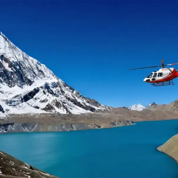
Inde, koma makamaka pa ntchito yopulumutsa anthu kapena yobwereketsa anthu payekha. Mutha kubwereka imodzi kuchokera ku Pokhara kupita ku Manang, Muktinath, kapena ngakhale Jomsom, koma ndi yokwera mtengo, pafupifupi USD 400–700 pa munthu aliyense. Ma helikopita amagwiritsidwa ntchito makamaka pazochitika zadzidzidzi kapena maulendo apamwamba.
Kodi ndingabwereke njinga kapena njinga yamoto panjira ya Annapurna?
Inde, mutha kukwera njinga zamoto kuchokera ku Muktinath kupita ku Pokhara. Komabe, msewuwu ndi wovuta, wotsetsereka, komanso wafumbi pakati pa Tatopani ndi Jomsom. Mudzafunika chidziwitso chakunja kwa msewu komanso chilolezo chovomerezeka chapadziko lonse lapansi. Ndi ulendo wosangalatsa koma sulimbikitsidwa kwa oyamba kumene.
Ndataya chilolezo changa cha ACAP pakati pa nthawi. Ndiyenera kuchita chiyani?
Ngati mwataya, pitani ku malo ofufuzira kapena ku polisi omwe ali pafupi nanu. Adzakupatsani china ngati muwonetsa pasipoti yanu ndi zithunzi. Mungafunike kulipira ndalama zochepa. Ndi bwino kusunga chithunzi cha digito cha zilolezo zanu pafoni yanu ngati chosungira.
Kodi ndingalembetse ACAP ndi TIMS pa intaneti?
Pakadali pano, zilolezo zonse ziwiri zimapezeka paokha ku maofesi a Tourism Board ku Kathmandu kapena Pokhara. Makina apaintaneti sakhala odalirika kwa alendo ochokera kumayiko ena. Bweretsani zithunzi ziwiri zazikulu za pasipoti, pasipoti yanu, ndi ndalama zolipirira. Njirayi imatenga pafupifupi mphindi 30-45, ndipo tidzachita.
Pasipoti yanga yatsala pang'ono kutha ntchito pakatha miyezi iwiri. Kodi ndingathe kuyendabe pansi?
Ndi zoopsa. Kusamukira ku Nepal kumafuna kuti pasipoti yanu ikhale yogwira ntchito kwa miyezi isanu ndi umodzi kupitirira tsiku lanu lolowera. Mutha kuloledwa kulowa, koma kuikonzanso musanapite kumapewa mavuto panthawi yolembetsa ziphaso ndi kulowa.
Ndinalowa mdziko lolakwika kapena tsiku lomwe ndinalandira chilolezo. Kodi izi zingayambitse mavuto?
Zolakwika zazing'ono za kalembedwe nthawi zambiri zimakhala zabwino, koma dziko lolakwika kapena manambala olakwika a pasipoti angayambitse mavuto pamalo ofufuzira. Nenani nthawi yomweyo kwa membala wa bungwe kapena ofesi yopereka chilolezo ku Pokhara kapena Kathmandu kuti akonze. Ndi zaulere ngati zitachitika tsiku lomwelo.
Kodi ana amafunikanso zilolezo zoyenda pansi?
Inde, aliyense wolowa m'dera losungirako zachilengedwe amafunika chilolezo cha ACAP, ngakhale ana. Koma kwa ana osakwana zaka 10, nthawi zambiri chimaperekedwa pamtengo wotsika kapena kwaulere, kutengera ofesi yakomweko. Makolo ayenera kunyamula pasipoti ya mwana ndi chithunzi chake.
US$ 970 munthu aliyense
- Chigulitsiro Chamtengo Wapatali
- Njira Yolipirira Yotetezeka
- Ulendo Wokonzedwa ndi Woyenera Munthu Aliyense
- Makasitomala obwerezabwereza 70%

Thandizo la Moyo la 24 X 7

Puru (+977-9851069558)
Maulendo Ofananira

Zaposachedwa Kuchokera ku Blog Yathu Malo okongola, malangizo oyendera, nkhani ndi zina zambiri.
Annapurna
Kodi pali masiku 14 ovuta kuyenda mu Annapurna Circuit Trek?
Kodi Ulendo wa Annapurna Circuit Trek ndi Wovuta Motani? Ulendo wa Annapurna Circuit Trek ndi wachiwiri kwa ambiri…
Werengani positi yonse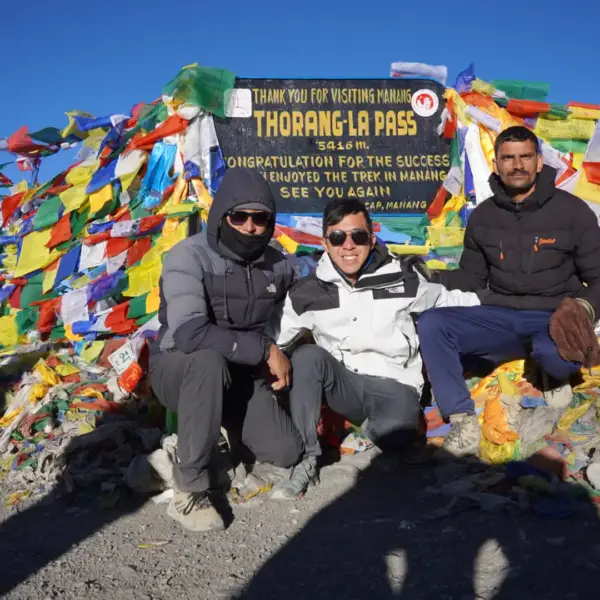
Annapurna
Ulendo wa Annapurna Circuit mu Okutobala
Ulendo wa ku Annapurna Circuit mu Okutobala? Chigawo cha Annapurna ndi malo otchuka oyendera maulendo ku…
Werengani positi yonse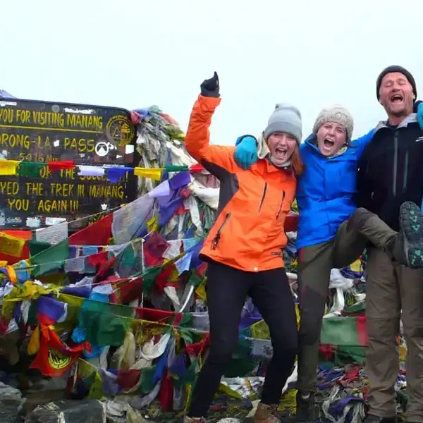
Annapurna
Ulendo wa Annapurna Circuit mu Seputembala
Ulendo wa Annapurna Circuit mu Seputembala ndi nthawi yabwino kwambiri yokumbukira ulendo wachiwiri wotchuka kwambiri…
Werengani positi yonse