
11 Egun
Quick gertaerak
Lurreko garraioa Nepalen
Hotelak eta te-etxeak
Katmandun izan ezik, otordu guztiak
Bisita gidatua eta ibilaldia bidaia osoan zehar
Udazkena, Udaberria
Mugatzea
Nepal
5,357 m
Katmandu - Lukla - Gokyo Ri - Lukla - Katmandu


Zergatik egin 11 eguneko Everest Gokyo Ri trekkinga?
- Iritsi Gokyo Ri-ra (5,360 m) lau 8,000 m-ko gailurren ikuspegi zabalak izateko, Everest mendia (8848.86 m), Lhotse (8,516 m), Artikuluak (8,485 m), eta Cho oyu (8,188 m).
- Bisitatu urruneko herri Gokyoko, 4,790 metrotan kokatua.
- Gurutzea Ngozumpa glaziarra (22KM), Himalaiako glaziarrik luzeena.
- Oinez bakarrik iristeko moduko sherpa kokalekuak behatu.
- Bizi ezazu paisaia erronka handikoak, basotik hasi eta Alpeetaraino eta glaziar eremuetaraino.
- Iritsi altitudeetara egokitzea ezinbestekoa den altueretara.
- Ibilaldia Sagarmatha Parke NazionalaBat UNESCOk Gizateriaren Ondare.
- Urruneko kokalekuetatik igaro, hala nola Dole Machhermo.
Bidaiaren ikuspegi orokorra
Everest igotzea ez badago zure ametsen zerrendan, zer moduz haren ondoan mendi-ibiliak egitea izozte edo porrot arriskurik gabe? Everest Gokyo Ri-ko ibilaldia altitude handiko bidaia da Gokyo aintzirak Gokyo RiIbilaldi honek munduko lau mendirik altuenak gertutik ikusteko aukera ematen du: Everest, Lhotse, Makalu, eta Cho oyu.
Ibilaldi hau aproposa da Everest kanpaleku nagusirako ibilbidearen alternatiba abenturazale eta jende gutxiagokoa nahi dutenentzat. Gokyo haranetik igarotzen den ibilbide luzeagoa eta erronka handiagoa dakar, eta horrek lehen aldiz ibiltzen diren ibiltari gutxiago erakartzen ditu. Everest eskualdea bisitatzen duten ibiltarien % 20-25 inguruk ibilbide hau aukeratzen dute, eta gehienek ibilbide klasikoa jarraitzen dute. EBC arrastoa.
Eskualdean sherpa herriak daude, non Tibetar budista tradizioak eguneroko bizitzaren parte dira. Otoitz banderak, mani hormak eta chortenak bidea lerrokatzen dute, eta Gokyo aintzirak sakratutzat hartzen dituzte bai budisten bai hinduen arteanEra berean, Sagarmatha Parke Nazionaletik igaroko zara, Gizateriaren Ondare dena. Bertan, Himalaiako tahrra, orein muskatua eta Himalaiako monala, grandala eta mendiko usoa bezalako fauna ikusteko aukera izango duzu.
Ibilaldi honetarako Luklara hegazkinez joan behar duzunez, Lukla erabat inguratzen duen ibilbide ezagun berri bat dago, bakarrik bazoaz har dezakezuna. Ihegazkinez joan beharrean, Katmandutik Phaphlura autoz joan zaitezke, gero Surkhetik Phakdingera oinez eta gero Namche BazarHala ere, 2-3 egun gehiago gehi diezazkioke zure ibilaldiari.
The Gokyoko ibilaldia Nepalgo ikusgarrienetako eta aberasgarrienetako bat da Himalaiako abenturak, jende gutxiago eta paisaia liluragarriak bilatzen dituzten mendizaleentzat aproposa. Ibilaldi ertain edo erronka handiko honek edertasun handiko lekuetatik eramango zaitu Sherpa herriak, Gokyoko aintzira turkesak eta mendi-paisaia zoragarriak. Aipagarriena ibilaldia da Gokyo Ri, non Everest eskualdeko ikuspegi panoramikorik ederrenetako batez gozatuko duzun, Everest, Lhotse, Makalu eta Cho Oyu barne. Kristalezko aintzirekin, glaziar dotoreekin eta egunsenti ahaztezinekin, Gokyo Trek-ek lasaitasuna, paisaia ederra eta bizitza aldatzen duen trekking esperientzia eskaintzen du Himalaiaren bihotzean.
Glaziar haranekin, laku sakratuekin eta bidean jende gutxiagorekin altitude handiko ibilaldi bat nahi baduzu, hau da. Everest Gokyo lakuko ibilaldia ibiltzeko, eskalatzeko eta esploratzeko espazio handiena eskaintzen du Everest Base Camp presaka.
11 eguneko Everest Gokyo Ri trekking ibilbidea
Eguna 01: Hegan egin Kathmandutik Luklara, eta gero Phakdingera oinez joan.
Zure 11 eguneko Everest Gokyo Ri Trek-erako bidaia goizeko hegaldi batekin hasiko da (6:00-10:00 AM) Katmandutik Luklara (2,800 m). Lukla Everesterako atea bezala ezagutzen den herri txiki bat da.
Lehorreratzean, zamaketariak etorriko dira taldearekin topo egitera, eta Chheplung herrixkatik zehar ibiltzen hasiko zara, non Kusum Kangururen (6,367 m) lehen ikuspegiak ikusiko dituzun. Ondoren, Dudh Koshi ibaia jarraituko duzu eta Thado Koshi-n zure lehen zubi esekia zeharkatuko duzu.
Eguerdi aldera, Ghat-era iritsiko zara eta pinu basoetan zehar ibiltzen jarraituko duzu, mani horma margotuak igaroz, Kusum Khola zeharkatu aurretik. Phakding-era iristean, Rimishung monasterioa ikusiko duzu gertuko gailur batean. Lehen egun labur honek zure gorputzari altitudeari egokitzen laguntzen dio eta glaziar, laku eta goi mendi haranetako zure ibilaldiaren hasiera ofiziala markatzen du.
OharHilabete puntakoetan, hala nola martxoan, apirilean, maiatzean, irailean, urrian eta azaroan. Luklarako hegaldia Manthalitik (Ramechhap barrutia) joateko aukera gehien dago, aire-trafikoa dela eta. Beraz, baliteke goizaldean 5-6 ordu lehenago gidatu behar izatea Luklarako hegaldia hartzeko.
Gosaria, Bazkaria, Afaria
teahouse
9 km / 5.6 milia
2,800 m / 9,186 ft
3hrs
Eguna 02: Ibilaldia Phakding-etik Namche Bazara
Eguna Dudh Koshi ibaiaren ondotik ibiliz hasiko duzu, 130 km inguruko luzera duena. Totok eta Benkar herrietatik igaroko zara, eta handik Thamserku (6,608 m) mendia ikus dezakezu muinoan. Zubi eseki bat zeharkatu ondoren, Monjo (2,835 m) iritsiko zara, sarrera puntura. Sagarmatha Parke NazionalaHemen, zure baimenak egiaztatuko dira Jorsalletik jarraitu aurretik.
Jorsalletik aurrera jarraituko duzu eta Hillary zubi esekia zeharkatuko duzu, bideko zubirik altuena, eta rododendro basoan zehar igotzen hasiko zara. Bide luzean, zerua garbi badago, Everest mendia ikus dezakezu. Arratsalde amaieran, Namche Bazaarrera iritsiko zara, Khumbu eskualdeko merkataritza eta kultura gune nagusia eta Everest Gokyo Ri bidaian geldialdi garrantzitsu bat.
Gosaria, Bazkaria, Afaria
teahouse
10 km / 6.2 milia
3,440 m / 11,286 ft
5hrs
Eguna 03: Aklimatazio Eguna Namche Bazaar-en
Gokyo lakuko trekking egun honetan, Namche Bazaar-en (3,440 m) ostatu hartuko duzu, zure gorputza altitude handiagoetara egokitzen laguntzeko. Goizean, Everest View Hotelera (3,880 m) igoko zara, munduko altituderik handienetako hoteletariko batera.
Bidean, Syangbocheko aireportutik (3,780 m) igaroko zara, hegazkin txikientzako lurreratze-gune gisa balio duena. Hoteleko ikuspuntutik, mendikate zabala ikusiko duzu, besteak beste, Everest, Lhotse, Ama Dablam eta Thamserku.
Ibilaldiaren ondoren, Namchera itzuliko zara bazkaltzera eta egunaren gainerakoa herria arakatzen pasatuko duzu. Sherpa kulturaren museoa eta Parke Nazionaleko Bisitarien Zentroa bisita ditzakezu, Everest eskualdeko tokiko tradizioak, geografia eta historia azaltzen dituena. Namcheko dendek eta okindegiek atseden hartzeko eta indarberritzeko lekua eskaintzen dute.
Gosaria, Bazkaria, Afaria
teahouse
4 km / 2.5 milia
3,880 m / 12,730 ft
3hrs
Eguna 04: Trek Namche Bazaar-etik Dholeraino
Namchen egun osoa eman ondoren, Kyangjumarantz doan ibilaldia hasiko duzu. Denbora pixka bat igaro ondoren, Sanasara iritsiko zara eta Mong Larantz (3,957 m) doan goiko bidea hartuko duzu, nondik Ama Dablam eta Kangtega (6,782 m) ikus daitezkeen. Phortse Thengara (3,680 m) jaitsiko zara, Dudh Koshi ibaiaren ondoko ibaiertzeko eremu batera. Puntu honek Gokyo haranerako sarrera markatzen du.
Phortse zeharkatu ondoren, ibaiaren gaineko egurrezko zubi bat zeharkatuko duzu eta basoen arteko goranzko zatia hasiko duzu. Thenga herrixkatik igaroko zara eta Dholera jarraituko duzu oinez, Taboche gailurra (6,495 m) ikus daitekeen herrixka batera. Gaua Dholen pasako duzu.
Gosaria, Bazkaria, Afaria
teahouse
12 km / 7.5 milia
3,957 m / 12,982 ft
6hrs
Eguna 05: Dholetik Machhermora egindako ibilaldia
Bosgarren egunean, Dhole-tik (4,200 m) hasiko duzu eguna eta Lhabarma (4,330 m) herrixka txikietatik igarotzen den bidea jarraituko duzu, eta gero Luzara (4,390 m) iritsiko zara, non Cho Oyu (munduko seigarren mendirik altuena) ikusi ahal izango duzun. Yak larreak eta chorten txikiak ikusiko dituzu poliki-poliki altuera irabazten duzun heinean.
Eguerdirako, Machhermora iritsiko zara, 1974an Yeti bat ikusi izanaren gertakariagatik ezaguna den lekura. Bertan atseden hartu eta harana esploratu ahal izango duzu egunaren gainerakoan. Machhermoko Himalaiako Erreskate Elkartearen postuak ere egunero hitzaldi bat ematen du altuerako segurtasunari buruz, eta hori garrantzitsua da Everest Gokyo Ri trekking ibilbidean.
Gosaria, Bazkaria, Afaria
teahouse
10 km / 6.2 milia
4,470 m / 14,665 ft
5hrs
Eguna 06: Machhermotik Gokyora egindako ibilaldia
Goizean goiz, Machhermotik hasiko duzu ibilaldia eta Dudh Koshi ibaia jarraituko duzu. Jaitsiera labur baten ondoren, Pangkatik (4,390 m) igaroko zara. Hemendik, Ngozumpa glaziarraren amaierako morrena ikusiko duzu, Nepalgo glaziar luzeena, 36 km ingurukoa. Ondoren, erreka baten gaineko zubi bat zeharkatu eta gora jarraituko duzu lehenengo Gokyo lakuraino, Longpongo Tsho (4,690 m) bezala ezagutzen dena.
Bigarren aintziratik igaroko zara, Taboche Tsho (4,710 m), eta eguerdirako hirugarren aintzirara iritsiko zara, Dudh Pokhari (4,790 m), eta ondoan dago Gokyo herrixka. Asentamendu hau Cho Oyuren azpian dago, eta hemendik Ngozumpa glaziarraren goiko aldea ikus daiteke.
Gosaria, Bazkaria, Afaria
teahouse
12 km / 7.5 milia
4,790 m / 15,715 ft
4-5 ordu
Eguna 07: Arakatu Gokyo harana, igo Gokyo Ri eta egin ibili bosgarren lakura
Egun hau Gokyo eskualdea esploratzeko izango da. Goiza goiz hasiko duzu Gokyo Ri-ra (5,360 m) igoz. Gailurretik, munduko lau gailurrik altuenen ikuspegi panoramikoak ikusiko dituzu: Everest, Lhotse, Cho Oyu eta Makalu, baita Ngozumpa glaziar osoa ere. Gailurrean denbora pixka bat eman ondoren, Gokyora jaitsiko zara berriro.
Eguerdirako, iparralderantz joango zara laugarren aintzirarantz, Thonak Tsho (4,840 m), eta gero bosgarren aintzirara iritsiko zara, Ngozumpa Tsho (4,980 m). Hemendik, Cho Oyuren ikuspegi hurbilak ikusiko dituzu. Aintzirak Ngozumpa arroaren goiko glaziar urtuak elikatzen ditu.
Eremua esploratu ondoren, Gokyo herrira itzuliko zara gaua pasatzera. Everest Gokyo Ri trekking ibilbideko egun honek altitude handiko bistak eta glaziar-lakuen esplorazioa eskaintzen dizkizu egun oso batean.
Gosaria, Bazkaria, Afaria
teahouse
14 km / 8.7 milia
5,360 m / 17,585 ft
7hrs
Eguna 08: Gokyotik Dholera egindako ibilaldia
Gaur, Gokyotik jaisten hasiko zara Dudh Pokhari lakuaren ondoko bide bera jarraituz, Ngozumpa glaziarraren mendebaldeko zatitik jaitsi aurretik. Altitudea galtzen duzun heinean, Gokyoko harrizko hormaz inguratutako larreetatik igaroko zara eta Phangkara iritsiko zara.
Phangkatik, Machhermorantz jarraituko duzu, iparraldean dagoen Cho Oyu mendiaren ikuspegi ederrak ikusiz. Machhermotik, Luzatik behera jaitsiko zara Dholera (4,200 m) iristeko. Everest Gokyo Ri trekking ibilbidearen zati honek goi-mendiko eremua utzi eta altitude baxuagoetarako prestatzeko aukera ematen dizu.
Gosaria, Bazkaria, Afaria
teahouse
15 km / 9.3 milia
4,790 m / 15,715 ft
7hrs
Eguna 09: Trek Dholetik Namche Bazara
Dholetik, Luza aldera jaitsiko zara Dudh Koshi gaineko bideak igaroz. Ibilaldi labur baten ondoren, Phortse Tengara iritsiko zara, bi ibai, Dudh Koshi eta bere ibaiadarrak, elkartzen diren lekura. Bideak Mong La aldera eramango zaitu, non Ama Dablam eta Thamserku bezalako gailurrak azken aldiz gertutik ikusi ahal izango dituzun.
Mong Latik, basoan zehar ibiliko zara Kyangjumara iristeko. Hemendik, Tengboche eta Everest kanpaleku nagusirako bideen elkargunea ikusiko duzu. Ondoren, Namche Bazaarrerantz (3,440 m) jarraituko duzu, eta han berriro ere Everest eskualdeko ibilbide ezagunekin konektatuko zara.
Gosaria, Bazkaria, Afaria
teahouse
14 km / 8.7 milia
3,957 m / 12,982 ft
6hrs
Eguna 10: Trek Namche Bazaar-etik Luklara
Sherpa gunea utzita, Hillaryko Zubi Eseki aldera jaitsiko zara. Zubia zeharkatu ondoren, Monjo eta Jorsalle bezalako herrietatik igaroko zara, eta Sagarmatha Parke Nazionaleko sarrera ikusiko duzu. Bhote Koshi eta Dudh Koshi ibaien elkargunea berriro ikusiko duzu Larja Dobhan ondoan.
Eguerdirako, Phakdingera iritsiko zara eta Ghat eta Thado Koshi zeharkatuko dituzu, hainbat zubi eseki zeharkatuz. Chheplung igaroko duzu Luklara iritsi aurretik, Everest Gokyo Ri trekkingaren zirkuitua amaitzen den tokira.
Gosaria, Bazkaria, Afaria
teahouse
19 km / 11.8 milia
3,440 m / 11,286 ft
7hrs
Eguna 11: Hegan egin Katmandura itzultzeko
Goizaldean, Luklatik Katmandura hegaldia hartuko duzu. Hegaldiak denbora gutxi irauten du eta Dudh Koshi harana jarraitzen du, zeharkatu dituzun Himalaiako paisaien azken ikuspegia emanez.
Katmanduko Tribhuvan Nazioarteko Aireportuan lurreratzen zarenean, zure ibilaldia ofizialki amaitzen da. Hotelean sartu ondoren, egunaren gainerakoa libre izango duzu. Mendizale askok denbora hori atseden hartzeko, Asan edo Thamel bezalako tokiko merkatuak arakatzeko edo Boudhanath edo Pashupatinath bezalako kultura-lekuak bisitatzeko erabiltzen dute.
Breakfast
Hotel
2,800 m / 9,186 ft
11 eguneko Everest Gokyo Ri trekking mapa
Zer Espero?
Zer dago barne
Aireportuko jasotze eta uzteko zerbitzuak
- Nazioarteko iristen direnen bilketa
- Aireportu nazionaletik hotelera eramateko zerbitzua (ibilaldiaren hasiera)
- Aireportu nazionalean jasotzea eta hotelera eramatea (ibilaldiaren ondoren)
- Nazioarteko irteera-bidaia zure azken egunean
Ostatu Zerbitzuak
- 10 gau mendietako te-etxe lokaletan (bikoteka partekatuta)
Trekking Baimena
- Tokiko Gobernuaren Sarrera Baimena (Trek Txartela)
- Sagarmatha Parke Nazionaleko Baimena (Everest Baimena)
Etxeko hegaldiak
- Katmandurako Luklarako hegaldi txartela
- Luklatik Katmandurako hegaldi txartela
Luklako hegaldiaren kasuan, Ramechhapetik igaroz
- Katmanduratik Ramechhapera joan-etorria garraio partekatuan
- Ramechhapetik Luklara bitarteko barne-hegaldi txartela
- Luklatik Ramechhapera doan barne hegaldi txartela
- Ramechhapetik Katmandura Jeep bat partekatuz
Janaria Katmandun/Trekking-ean
- 10 Gosaria: Tokiko eta kontinental aukerak te-etxetik Menua
- 10 Bazkaria: Bazkari sinple eta arina lunch camp-eko te-etxeetan
- 10 Afaria: Aukerako otordu begetarianoak eta ez-begetarianoak, tokiko te-etxeko janari nepaldarrak eta kontinentalak Menua
Gida/Amatzaile Zerbitzuak eta Haien Erantzukizunak
- Gure taldeak eramandako lehen sorospenen kita
- Trekking gida – Ingelesez hitz egiten duen gida lizentziaduna, 10 urte baino gehiagoko esperientziarekin.
- Gida eta Zamaltzaileentzako Aseguruak (Larrialdietako ebakuazioa eta istripuzko gastu medikoak)
- Gidari/zamatzaileentzako otordu guztiak
- Enpresaren ohiko tarifan oinarritutako soldata (turismo sektoreko elkarteak gomendatzen duena)
- Gehienez 20 kg-ko ekipajea eramateko tokiko sherpa (2 gonbidatuk zamalari 1 partekatuz)
- Bidaia eta Erreskate Antolamenduak
Zer dago baztertuta
- Otorduak Katmandun trekkingaren aurretik eta ondoren,
- Zure bidaia asegurua (Salbamendua)
- Nepalen sartzeko bisa-kuota.
- Trekkingeko langileentzako eta gidarientzako aholkuak
- Edariak (beroak, hotzak eta alkoholdunak)
- Erosketa pertsonalak, garbiketa, etab.
- Trekking ekipamendu pertsonala.
Tripadvisor Iritziak
Google Reviews
11 eguneko Everest Gokyo Ri trekkinga Informazio gehigarria
Zenbat balio du Gokyo Ri-ra joateak?
The 11 eguneko Gokyo Ri-ko ibilaldiak 1,000-1,550 USD balio du pertsonako, taldeentzako deskontuak eskuragarriKostuak ibilaldiko gastu guztiak estaltzen ditu, besteak beste, Katmandu eta Lukla arteko barne-hegaldiak, te-etxeetan ostatua, otordu guztiak, Sagarmatha Parke Nazionalerako baimenak eta Khumbu Pasang Lhamu Landa Udalerrirako baimenak. Badira... ezkutuko kargurik ez, eta prezioa BEZa eta aplikagarri diren zerga guztiak barne hartzen ditu.
Zure ordainketak giden eta zamaketarien soldatak, Everest Gokyo Ri trekking ibilbidea mantentzen laguntzen duten ingurumen-tasak eta ibilaldi seguru eta leuna bermatzeko logistika ere barne hartzen ditu. Kostuen banaketa honek dena barne hartzen du, beraz, bidaian zentratu zaitezke gastu gehigarri edo ustekabekorik gabe.
Zer espero daiteke Everest Gokyo Ri trekkingean?
Gokyo Rirako bidaia liluragarriak definitzen du txanda bakoitzean, paisaia anitzak, altitude handiko bistak eta aukera anitzak eskaintzen baititu. Hona hemen Gokyo Riko ibilaldian zer espero dezakezun:
Gokyo Ri, 5,357 metrokoa, 8,000 metroko lau gailurren ikuspegiengatik ezaguna.
Espero dezakezu Gokyo Ri igotzea, mendebaldean dagoen trekking gailurra Ngozumpa glaziarraGailurretik, ikus dezakezu Everest (8,8848.86 m), Lhotse (8,516 m), Artikuluak (8,481 m), eta Cho oyu (8,188 m) ikuspegi bakarrean.Gokyo herrixkatik igotzeko 2-3 ordu inguru behar dira, eta bideak erritmo motela eskatzen duten zati aldapatsuak eta harritsuak ditu.
Machhermo, 1974ko Yeti gertakari historikoagatik famatua
Gokyo lakuaren ibilaldi honetan, Machhermotik igaroko zara. Hemen dago: 4,470 m eta hori da 1974an yeti erasoagatik gogoratzen daBertako kontakizunen arabera, hiru yak hil ziren eta sherpa emakume bat zauritu zen gertakarian. Istorioa herriaren memorian gorde da eta askotan gidariek partekatzen dute, jendeari helarazten dioten heinean.
Bosgarren Gokyo aintzira, 4,980 m-tan, Everest mendiaren iparraldeko aurpegiaren ikuspegiengatik famatua
Mendi-ibiliak egin ditzakezu bosgarren Gokyo aintzira, Gokyo herriaren iparraldean kokatua eta Ngozumpa Tsho bezala ere ezagunaAlboko bidetik irits daiteke bertara Ngozumpa glaziarraBere kostaldetik, Everest mendiaren iparraldeko aurpegia eta beste gailur batzuk ikus daitezke, hala nola Gyachung Kang (7,953 m). Laku-eskualde hau mendizaleek gutxiago bisitatzen dute eta askotan isilagoa herrigune nagusia baino.
Antzara buru-barraduna bezalako sasoiko hegaztiak Gokyo lakuen ondoan migratzen dute
Gokyo aintziren inguruko hezeguneak hegazti migratzaileentzako atsedenleku bihurtzen dira, hala nola... antzara buru-barraduna, kurrilo lepo-beltza, eta tarta gorrixkaMigrazio hauek montzoi aurreko (apiriletik maiatzera) eta montzoi osteko (irailetik urrira) garaian nabaritzen dira. Altitude handiko aintzirek janaria eta aterpea eskaintzen dituzte, eta behaketek ekologia aldetik nabarmentzen dute ibilaldia.
Trekaren inguruko te etxeak
Everest mendiko oinarrizko kanpalekua, Gokyo Ri trekkingarekin batera, azken hamarkadetan hazi den te-etxe sare ondo garatu batek babesten du. Namche Bazaar, Phakding, Machhermo eta Gokyo bezalako herrixkek urte osoan zehar mendizaleentzako lekua duten te-etxe nahikoa dituzte. Te-etxeetako praktikak... 1960ko hamarkada inguruan aurkeztu zen, eskualdean trekkinga ezagunagoa bihurtu zenean. Aterpe hauek oinarrizko aterpea eta atsedenlekuak eskaintzen dituzte, eta horiek funtsezkoak dira altuera handiagoetan aklimataziorako eta segurtasunerako.
Te-etxeak gutxi gorabehera distantzia berean daude 3 6 ordu arte altueraren igoerarekin egokitzen diren eguneroko trekking segmentu kudeagarriak sortzeko. Gokyo herriko eta Machhermoko te-etxeak 4,400 m-tik gora daude, munduko trekking aterperik altuenen artean. Haien presentziak atseden freskagarri bat hartu eta etxeko janari nutritiboekin elikadura emateko aukera ematen dizu.
Zerk zailtzen du Everest Gokyo Ri-ko ibilaldia?
Everest Gokyo Ri-ko ibilaldiak altitude handia du, 2,860 m Luklan. 5,357 m Gokyo Ri gailurrean. 5,300 m-tan, oxigeno mailak %50era jaisten dira gutxi gorabehera itsas mailan daudenen artean, eta horrek gorputzean tentsioa eragiten du eta handitzen du altitude-gaixotasunaren arriskuaIbilbide honetako batez besteko eguneroko trekking distantzia honako hau da: 8 eta 12 km, askotan estalita 5 7 ordu arte bide harritsu eta irregularretatik, eta horrek ibilaldiaren zailtasuna areagotzen du.
Trekkingarekin egiteko, egoera fisikoak indar kardiobaskular ona eta hanketako indar ona eskatzen ditu. 7 eta 10 kilogramo arteko motxilaOxigeno maila baxuetan erritmo egonkorra mantendu eta egun luzeen ondoren ondo errekuperatu ahal izan beharko zenuke. Gokyo inguruko eguraldi baldintzak honako hauek dira: 5 °C eta -15 °C artean, elurte edo haizete ohikoak direlarik. Beraz, oxigeno gutxiko, lurzoru erronkadun, eguraldi aldakor eta trekking ordu luzeen konbinazioak ibilaldi hau erronka handia bihurtzen du.
Gokyoko trekkingerako garairik egokiena
The denborarik onena Everest Gokyo Ri trekking-a hemendik dator irailaren amaieratik azarora eta batetik Martxotik maiatzaren hasieraraHilabete honetan, eskualdeak prezipitazio gutxiago izaten du, hilean batez beste 30-50 mm-ko prezipitazioarekin, % 40 eta % 60 arteko hezetasunarekin eta hodei-estaldura % 30etik beherako batez bestekoarekin. Baldintza hauek... zeru garbia, mendi ikuspegi ederrak, eta gehiago eguraldi egonkorra by ikusgarritasuna eta segurtasuna hobetzea bidean.
Aitzitik, montzoi denboraldia ekainetik abuztura euri jasa handiak dakartza, askotan hilean 300 mm baino gehiago izaten dira, hezetasuna % 80tik gora igotzen delarik. Abendutik otsailera bitarteko neguko hilabeteetan prezipitazio gutxi izaten da, baina tenperaturak azkar jaitsi daitezke -15 °C-tik behera Gokyo inguruan. Izozte-arriskua handitzen du eta zaildu egiten du trekkinga. Beraz, udazkenak eta udaberriak eskaintzen dute eguraldi fidagarriena trekkinga osatzeko, baldintza egokiekin.
Everest Gokyoko trekking baimena
Everest Gokyo Ri-ko ibilaldiak honako hauek eskatzen ditu: bi baimen nagusiDira: Sagarmatha Parke Nazionaleko Baimena eta Khumbu Pasang Lhamu Landa udalerriko baimenaSagarmatha Parke Nazionaleko Baimena, 1976an Nepalgo Parke Nazionalen eta Fauna Kontserbatzeko Sailak ezarria, 30 USD balio du atzerritarrentzat 15 USD SAARCko herritarrentzat. Era berean, Khumbu Pasang Lhamu Baimena 25 USD inguru balio du eta Khumbu eskualdeko trekking jarduerak arautzeko tokiko gobernuak eman du.
Bi baimenak izan daitezke Katmandun lortutako ibilaldiaren aurretik edo parkearen sarreratik gertu dauden bulegoetan, Monjon adibidez. Baimen hauek bidaia osoan zehar eraman behar dituzu, Jorsalle, Machhermo eta Namche bezalako kontrolguneetan egiaztatzen baitira. Baimen hauek zeregin garrantzitsua dute turismoa kudeatzeko, kontserbazio ahaleginak laguntzeko eta Everest eskualdeko tokiko komunitateei laguntzeko.
Zergatik aukeratu gurekin 11 eguneko Gokyo Trek-a?
Hona hemen gurekin Gokyo Trek aukeratzeko arrazoi batzuk:
- Everest Gokyo Ri trekkingean 10 urte baino gehiagoko esperientzia duten gida adituak ditugu.
- Geldialdi guztietan ostatua bermatuta te-etxeetan, Gokyo eta Machhermo barne.
- Mendi-ibiliak egiten dituzun bitartean altuerako gaixotasuna izateko arriskua murrizteko, jarraitu aklimatazio-egutegia zorrotz.
- Beharrezko baimen guztiak barne: Sagarmatha Parke Nazionala eta Khumbu Pasang Lhamu.
- Egunero 8 eta 12 km arteko trekking distantziak aurreikusita, erritmo egokia izateko.
- Luklan eta Namche Bazaarren 24/7 larrialdietarako laguntza eta ebakuazio-antolamenduak.
- Prezio gardenak, ezkutuko tasarik edo ustekabeko zergarik gabe.
- Ibilaldi aurreko informazio osoa, ibilbide zehatzarekin eta ekipamenduari buruzko aholkuekin.
Zein gailur ikus daitezke Gokyo Ri-tik?
Gokyo Ri-ren gailurretik, Himalaiako hainbat gailur nagusi ikus daitezke. Mendi hauek nabarmenak dira Everest eskualdean duten altueragatik eta garrantzi geografikoagatik. Hona hemen Gokyo Ri-tik ikus daitezkeen gailur nagusien zerrenda:
- Everest mendia (8,848.86 m): Ezaguna bezala "Sagarmatha" nepaleraz eta "Chomolungma" tibeteraz, Lurreko mendirik altuena da.
- Lhotse (8,516 m): Deitua "Hegoaldeko gailurra", mundukoa da laugarren mendirik altuena.
- Makalu (8,485) m): 8,000 metroko gailurrik zailenetakotzat hartzen da igotzeko.
- Cho oyu (8,188 m): Ezizena jarri zioten "Turkesazko Jainkosa", gailur hau eskalatzaileen artean ezaguna da, bere igoera-ibilbide errazagoa delako.
- Gyachung Kang (7,952 m): Hau da gutxien igotako mendia eta hamabosgarren mendirik altuena munduan.
- Tawoche (6,462 m): Gokyo ondoko mendi nabarmena.
- Ngozumpa Kang (7,206 m): A ur iturri nagusia Everest eskualderako.
Denboraldi kanpoan egin al dezakegu Everest Gokyo Ri mendira trekkinga?
Bai, Everest Gokyo Ri mendira joan zaitezke denboraldi kanpoan, eta horrek abantaila paregabe batzuk ditu. Neguan edo montzoian trekking egiteak aukera ematen du esperientziak bizitzeko... jaialdiak bezalakoak. Mani RimduUdazkenean egiten da, baina prestaketak eta zeremonia txikiagoak ikus daitezke hilabete ez-udazkenean. bideak lasaiagoak eta jende gutxiagokoak dira, eta horrek esan nahi du herrietako eguneroko bizitza ikusteko aukera gehiago daudela. Denboralditik kanpo mendi-ibiliak paisaia aldakorrak ikusteko aukera ere ematen dizu, hala nola neguan izoztutako lakuak or haran berdeak montzoian zehar.
Urtero mendizale guztien % 10-15 inguruk Gokyo Ri bisitatzen dute denboraldi kanpoan. Baina kontuan izan denboraldi kanpoan mendi-ibiliak prestaketa sendoa eskatzen du egiteko eguraldi hotza, bide-baldintzak aldatzen, eta te-etxe zerbitzu mugatuakDenboraldi kanpoan bidaia abenturazaleago bat bizi nahi baduzu, probatu Everest Cho La mendateko ibilaldia. Cho La bezalako mendi-mendate altuak barne hartzen ditu eta erronka fisiko eta nabigazio-arlo handiagoak eskatzen ditu.
Altuera maila eta distantzia osoa
Gokyo Ri-ren distantzia osoa ibilbide zehatzaren araberakoa da hartua. Hala ere, Luklatik hasi eta Gokyo Ri-n amaituz, behar da 40-45 km (25-28 milia) zirkuluan bidaiaIbilbide osoan zehar, mendizaleek toki garrantzitsuen kota desberdinetatik igarotzen dira, hauek dira:
| SN | kokapena | Altitudea |
| 1 | Luklatik | 2,800 m / 9,184 ft |
| 2 | Phakding | 2,652 m / 8,700 ft |
| 3 | Namche Bazar | 3,440 m / 11,283 ft |
| 4 | Dhole | 4,110 m / 13,480 oin |
| 5 | Machhermo | 4,470 m / 14,663 ft |
| 6 | Gokyo harana | 4,800 m / 15,744 ft |
| 7 | Gokyo Ri | 5,357 m / 17,570 ft |
Nola prestatzen zara Gokyo Ri trekking-erako?
Gokyo Ri trekking-erako prestatzeak entrenamendu fisikoa, buruko prestutasuna eta maleta arretaz prestatzea eskatzen du. Horrek segurtasuna, erosotasuna eta trekking-ean zehar esperientzia hobea bermatzen laguntzen du. Jarraian, bidaia prestatzeko urrats nagusiak azaltzen dira.
- FisikoaErresistentzia handitzeko, korrika egitea, bizikletan ibiltzea edo igeri egitea bezalako ariketa kardiobaskularretan zentratu. Lur zailei aurre egiteko, egin indar entrenamendua hanketarako, gorputz-enborrerako eta bizkarrerako. Mendi-ibiliak praktikatu motxila bete batekin, trekking baldintzak simulatzeko.
- Buru prestakuntzaIkasi altitude-gaixotasunari eta haren sintomei buruz, hasierako zantzuak ezagutzeko. Prestatu pazientzia eta egokitzapena eguraldi aldakorretan eta bide-baldintzetan.
- Paketatzeko ezinbestekoakEkarri -15 °C eta 10 °C arteko tenperaturetarako egokia den geruzadun arropa, arropa termikoa eta jaka iragazgaitzak barne. Ekarri orkatila ondo euskarritzen duten trekking botak. Sartu ezinbesteko ekipamendua, hala nola lo-zakua, trekking makilak, lehen sorospenetarako kita, ura arazteko tabletak eta eguzkitako babesa.
- Aklimatazio planaJarraitu gomendatutako ordutegia, atseden egunak Namche Bazaar bezalako puntu garrantzitsuetan, zure gorputza altitude aldaketetara egokitzeko.
- Bidaia-logistikaErreserbatu hegaldiak goiz, batez ere Katmandu-Lukla sektorekoak, prestatu eguraldi txarragatiko atzerapen posibleak edo hartu paketea gure eskutik; gu arduratuko gara denaz.
Tokiko gida eta zamaketariak
Nire Everest Bidaiaren alderdi berezi bat da gure bezeroei tokiko gida eta zamaketari bat eskaintzen diegu bidaiarako. Batez ere eskaintzen ditugu bertako sherpa gidak Himalaiako espedizioetarako, profesional esperientziadunak eta ausardiagatik ezagunak direnak. Eskualdeko bideak, paisaia eta kultura ezagutzen dituzte. Gure gida gehienak ibilaldia egiten den eremuetan jaio eta hazi dira. Eremuaren historiaren, ekosistema anitzaren eta kulturaren ezagutza osoa eskaintzen dute.
Gainera, gure zamaketariak mendizaleek igaro behar duten eremutik datoz, eta hori nekagarria izan daiteke, batez ere lur malkartsuan. Atseginak eta langileak dira, eta zure motxila guztiak eramaten dituzte ibilaldian kontzentratuta egoteko. Gure zamaketariak bertakoak direnez, tokiko ekonomia babestea dugu helburu haiek kontratatuz.
Bidaia bat konbinatu nahi baduzu, Gokyo Ri Everest-eko oinarrizko kanpalekuko ibilaldia, zuretzat pertsonaliza dezakegu.
Everest Gokyo Ri trek-ean otordu aukerak
Zehar Gokyo Ri-ko ibilaldia, hainbat otordu aukera zerbitzatzen dira bidean zehar dauden te-etxe eta ostatuetan. Dal Bhat, Tibeteko ogia, krepeak, arrautzak, patatak, tea eta bezalako elementuak kafea ostatu guztietan zerbitzatzen dira. Hona hemen ibilaldian zehar zerbitzatuko diren janarien taula argi bat.
| Breakfast | bazkaria | Afaria |
|---|---|---|
|
|
|
11 eguneko Everest Gokyo Ri trekking-ari buruzko maiz egiten diren galderak
Zein da 'Gokyo' izenaren jatorria?
'Gokyo' sherpa hizkuntzatik dator, eta "bost aintzira sakratu" esan nahi du. Ibilaldia haran honetatik igarotzen da, bertako sherpa komunitatearentzat garrantzi erlijiosoa duten glaziar aintzira multzoagatik ezaguna.
Ba al dago desagertzeko arriskuan dauden espezierik ikus dezaket Gokyo eskualdetik gertu?
Bai, eremua desagertzeko arriskuan dauden espezieen bizilekua da, hala nola elur-lehoinabarra eta Himalaiako ardi urdina (bharal). Turismoa gutxitan egiten da, baina haien presentziak eskualdearen garrantzi ekologikoa adierazten du.
Zein da Ngozumpa glaziarraren garrantzia eskualdeko hidrologian?
Ngozumpa glaziarrak urtutako ura ematen dio Dudh Koshi ibaiari, Koshi ibaiaren sistemaren ibaiadar nagusi bati. Bere bolumenaren aldaketek eragina dute ibaian behera dagoen uraren erabilgarritasunean, nekazaritzarako, edateko urarentzat eta energia hidroelektrikorako ibaiaren menpe dauden milaka pertsonentzat.
Zein da neguan Gokyo inguruan erregistratutako tenperatura baxuenaren erregistroa?
Neguan Gokyo inguruan erregistratutako tenperatura baxuena -20 °C (-4 °F) ingurukoa izan zen gauez. Altitude handiko haize bortitzek hotza areagotzen dute, eta horrek arropa eta ekipamendu egokia eskatzen du hipotermia eta izozteak saihesteko eguraldi hotzean.
Nola eragiten dute geologiak eta arroka motek Gokyo Ri trekkingeko bideen baldintzetan?
Bideak glaziar-jarduerak sortutako arroka sedimentario eta metamorfikoetatik igarotzen da. Arroka solteak, malda harritsuak eta morrena-gandorrak ohikoak dira, eta batzuetan bide-zati ezegonkorrak sortzen dituzte. Baldintza hauek oinetako onak eta plangintza egokia eskatzen dituzte.
Ba al dago bidean desagertzeko arriskuan dauden sendabelarrik aurki ditzakedana?
Bai, Yarsagumba (Cordyceps sinensis), desagertzeko arriskuan dagoen sendagai-onddo bat, bidearen inguruan aurki daiteke. Oso eskatua da medikuntza tradizionalean, baina arazoak ditu gehiegizko uzta dela eta.
Nola elkarreragiten dute altitudeak eta UV erradiazioak Everest Gokyo Ri mendiko ibilaldian?
Altitude handiagoek atmosfera meheagoa dute, eta horrek UV erradiazioen esposizioa % 50eraino handitzen du itsas mailarekin alderatuta. Horrek eguzki-erredurak eta begi-kalteak izateko arriskua areagotzen du; beraz, eguzki-babesa ezinbestekoa da altitude handiko ibilaldi bat egiten duen ororentzat.
Zein ordutan ikus dezaket Gokyo Ri gailurraren ikuspegi argiena?
Gokyo Ri gailurrean ikusgarritasun garbia izateko unerik onena goizaldeko ordu txikiak dira, 6:00etatik 8:00etara. Ordu horietan, haizearen abiadura txikiagoa da eta hodei gutxi, eta horrek mendiak ikusteko eta argazkiak ateratzeko baldintzak hobetzen ditu.
Zer paper jokatzen du yak-artzaintzak Gokyo haraneko komunitateetan?
Yak-hazkuntzak haragia, esnea eta garraioa ematen ditu. Yak-ak ezinbestekoak dira urruneko herrietara eta aterpetxeetara hornigaiak eramateko. Artzainketak Everest eskualdeko tokiko bizibideak eta kultura-praktikak laguntzen ditu.
Zer eragin dute mikroplastikoek Everest Gokyo Ri mendiko ingurunean?
Mikroplastikoek Everest Gokyo Ri mendi-ibilien ingurunean duten eraginari dagokionez, ur-iturrien eta ibilbideen ondoko lurzoruaren kutsadura dakar. Plastikozko partikula hauek baztertutako hondakinetatik datoz eta arriskuak sortzen dituzte tokiko faunarentzat eta ekosistementzat.
Zein fidagarriak dira eguraldi iragarpenak Everest Gokyo Ri eskualdean?
Eskualdeko eguraldi iragarpenek satelite bidezko datuak eta tokiko behaketak erabiltzen dituzte, baina mendiko eguraldi aldaketa azkarrak direla eta, aurreikusezinak izan daitezke. Ekaitzetarako eta tenperatura aldaketetarako prestatu behar zara, nahiz eta iragarpenak zeru garbia erakutsi.
Zeintzuk dira Gokyo Ri inguruan izan ditzakedan altuerako gaitzaren sintoma ohikoenak?
Buruko minak, zorabioak, goragalea eta nekea bezalako sintomak izan ditzakezu. Sintoma hauek 4,500 m-tik gorako altueretan oxigeno mailak gutxitzeagatik agertzen dira eta atseden eta egokitzapena behar dira kudeatzeko.
Zer txerto hartu behar ditut Everest Gokyo Ri mendi-ibilaldia egin aurretik?
A eta B hepatitisa, tifusa, tetanoa eta haurren ohiko txertoak hartzea gomendatzen da. Mendizale batzuek gripearen aurkako txertoa ere hartzen dute, eta sukar horiaren aurkako txertoa herrialde kaltetuetatik datozenentzat bakarrik da beharrezkoa. Txertoak urruneko eremuetan infekzio arruntak izateko arriskua murrizten laguntzen du mendi-ibilian zehar.
Zein gaixotasun arrunt izan behar ditut kontuan Everest Gokyo Ri trekkingean?
Arnas infekzioak, urdail-hesteetako arazoak, altitude-gaixotasuna eta lesio arinak bezalako arazo ohikoenei buruz jakin behar duzu. Oinarrizko lehen sorospenetarako kita eraman oinarrizko botikekin eta higiene-neurriak landu arrisku hori gutxitzeko.
Zein larrialdi-protokolo daude indarrean mendi-ibilietan osasun-arazoetarako?
Tokiko gidek eta agentziek ebakuazio planak dituzte, helikoptero bidezko erreskatea barne. Osasun-postuekin komunikatzea irrati edo satelite bidezko telefono bidez egin daiteke. Larrialdietako kontaktuen zenbakiak eta altitude handiko ebakuazioa estaltzen duen asegurua eraman behar dituzu.
US $ 1,250 pertsona bakoitzeko
- Best Prezioa Bermatua
- Ordainketa Sistema Segurua
- Ibilbide pertsonalizatua eta neurrira egina
- % 70 bezero errepikakorrak
24 x 7 zuzeneko laguntza

Puru (+977-9851069558)
Bidaia erlazionatuak
Mugatzea 🞄
 5.0 (175)
9 eguneko Ama Dablam oinarrizko kanpalekuko ibilaldia
9 egun Nepalen
Gure blogetik ateratako azkenak Leku erakargarriak, bidaia aholkuak, berriak eta gehiago.

Everest, Blog, gokyo, Gokyoko ibilaldia, Trekkinga Nepalen
Everest Gokyo Ri trekking-ari buruz jakin beharreko gauzak
Gokyo haranak "Heriotzaren Harana" deitzen dio, eta hala izan behar duen bezala...
Irakurri mezu osoa
Nepal, Bira Nepalen
Nepalgo 7 aintzira ederrenak
Nepalgo aintzira onenek edertasun natural harrigarria eta murgiltze kulturala eskaintzen dizkizute. Batzuk Rara dira…
Irakurri mezu osoa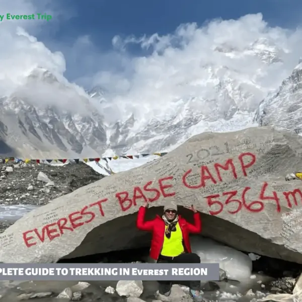
Everest, Blog, Trekkinga Nepalen
Everesteko trekking gida osoa
Everest Trekking Gida Everest Trekking Gida osoa mundu osoko trekking askoren artean dago, baina bat ere ez da...
Irakurri mezu osoa