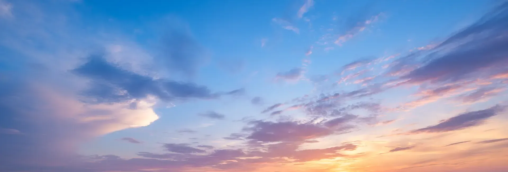
ກະລຸນາເບິ່ງຂອງພວກເຮົາ ແຜນທີ່ Manaslu Circuit Trek ເພື່ອຮຽນຮູ້ກ່ຽວກັບຈຸດຢຸດພັກທີ່ສຳຄັນ, ສະຖານທີ່ທ່ອງທ່ຽວ ແລະ ຄວາມງາມຂອງພາກພື້ນ. ສຳລັບການຜະຈົນໄພຍ່າງປ່າ, ພາກພື້ນ Manaslu ໄດ້ຮັບຄວາມນິຍົມໃນບັນດາຜູ້ທີ່ມັກການຍ່າງປ່າ. ເສັ້ນທາງທີ່ແປກປະຫຼາດ, ທຳມະຊາດທີ່ໂດດດ່ຽວ ແລະ ຄວາມງາມທີ່ໜ້າຕື່ນຕາຕື່ນໃຈດຶງດູດນັກທ່ອງທ່ຽວຈາກທົ່ວໂລກ. ການຍ່າງປ່າສະເໜີທິວທັດທີ່ງົດງາມຂອງພູ Manaslu, ພູທີ່ສູງທີ່ສຸດອັນດັບທີ 8 ຂອງໂລກ.
ແຜນທີ່ການຍ່າງປ່າ Manaslu ໃຫ້ຂໍ້ມູນລະອຽດກ່ຽວກັບສະຖານທີ່ສຳຄັນທັງໝົດ, ໄລຍະທາງ ແລະ ລະດັບຄວາມສູງທີ່ທ່ານຈະໄດ້ໄປ, ແລະ ເສັ້ນທາງທີ່ທ່ານຈະໄປ. ການມີແຜນທີ່ກັບທ່ານໝາຍຄວາມວ່າທ່ານຈະມີຜູ້ນຳທ່ຽວໄປນຳ. ແນະນຳໃຫ້ທ່ານເອົາແຜນທີ່ໄປນຳໃນການເດີນທາງ. ສິ່ງນີ້ຈະຊ່ວຍໃຫ້ທ່ານມີທິດທາງທີ່ເໝາະສົມ ແລະ ຊ່ວຍໃຫ້ການນຳທາງດີຂຶ້ນ.
ໄດ້ Manaslu Circuit Trek ມີຄວາມແອອັດໜ້ອຍລົງ, ຊຶ່ງໝາຍຄວາມວ່າມີຄົນໜ້ອຍລົງໃນເສັ້ນທາງ. ດັ່ງນັ້ນ, ການຊອກຫາຄວາມຊ່ວຍເຫຼືອຈາກຄົນອື່ນຈຶ່ງຂ້ອນຂ້າງທ້າທາຍໃນການເດີນທາງ. ຖ້າທ່ານຕ້ອງການເຂົ້າໃຈລະດັບຄວາມຫຍຸ້ງຍາກຂອງການຜະຈົນໄພ, ແຜນທີ່ກໍສາມາດຊ່ວຍທ່ານໄດ້ເຊັ່ນກັນ. ຕ້ອງການເຂົ້າໃຈເພີ່ມເຕີມກ່ຽວກັບ Manaslu Circuit Trekຄູ່ມືນີ້ແມ່ນສຳລັບທ່ານ.
ສາລະບານ
ຈຸດເດັ່ນຂອງການເດີນທາງໄປ Manaslu Circuit
- ຊົມວິວໃກ້ໆຂອງພູ Manaslu, ພູທີ່ສູງທີ່ສຸດອັນດັບທີແປດ, ພ້ອມກັບຍອດພູທີ່ສູງທີ່ສຸດຄື Annapurna, Ganesh Himal, Cheo Himal, ແລະ Ngadi Chili.
- ເພີດເພີນໄປກັບວັດທະນະທໍາ ແລະ ປະເພນີທີ່ໄດ້ຮັບແຮງບັນດານໃຈຈາກທິເບດຂອງຊາວ Gurung ແລະ Magar.
- ຍ່າງຜ່ານເສັ້ນທາງທີ່ບໍ່ຄ່ອຍມີຄົນໄປ ແລະ ເພີດເພີນກັບເສັ້ນທາງທີ່ງຽບສະຫງົບ, ເຮັດໃຫ້ທ່ານໃກ້ຊິດກັບທຳມະຊາດ.
- ທ້າທາຍຕົວເອງກັບການຍ່າງປ່າ ແລະ ຮູ້ສຶກເຖິງຄວາມສຳເລັດຫຼັງຈາກສຳເລັດການເດີນທາງ.
- ຄວາມຮູ້ສຶກອັນຍິ່ງໃຫຍ່ຂອງຜົນສຳເລັດຜ່ານການເອົາຊະນະ ລາກຢາລາ (5,160 ມ)
- ທ່ານຈະມີໂອກາດໄດ້ເຫັນສັດປ່າຊະນິດຕ່າງໆເຊັ່ນ: ໝີແພນດ້າແດງ, ເສືອດາວຫິມະ, ນົກອິນຊີ, ກວາງ Musk ແລະ ກວາງ Himalayan Tahr, ພ້ອມກັບພືດພັນທີ່ຫຼາກຫຼາຍ.
- ເຈົ້າສາມາດເຮັດທາງຜ່ານຊອຍ ແລະ ເຂດອະນຸລັກ Manaslu ໄດ້ບໍ? Budhi Gandaki V
Manaslu Circuit Trek Route
Manaslu Circuit Trek ເລີ້ມຕົ້ນ ດ້ວຍການຂີ່ລົດຜະຈົນໄພຈາກ Kathmandu ໄປຫາ Soti Khola. ການຍ່າງປ່າເລີ່ມຕົ້ນໃນມື້ທີສອງ. ບ້ານທຳອິດທີ່ພວກເຮົາຈະຢຸດຢູ່ແມ່ນ Machha Khola, ຕາມດ້ວຍ Jagat ແລະ Deng. ໃນຂະນະທີ່ພວກເຮົາເດີນທາງ, ພວກເຮົາຈະຍ່າງປ່າຢູ່ແຄມຝັ່ງແມ່ນ້ຳ Budhi Gandaki, ຂ້າມຂົວແຂວນ, ແລະຜ່ານປ່າໄມ້ທີ່ອຸດົມສົມບູນ ແລະ ທົ່ງນາຂັ້ນໄດ.
ໃນຂະນະທີ່ພວກເຮົາເຄື່ອນຍ້າຍສູງຂຶ້ນຈາກສະຖານທີ່ນີ້, ເສັ້ນທາງດັ່ງກ່າວມີຄວາມທ້າທາຍຫຼາຍຂຶ້ນ, ໂດຍສະເພາະເມື່ອພວກເຮົາເຂົ້າໃກ້ ບ້ານ Samagaon ແລະ Samdo. ພວກເຮົາຈະໄດ້ຊົມວິວທີ່ງົດງາມຂອງ Manaslu ແລະຍອດພູອື່ນໆຕະຫຼອດການເດີນທາງ. ຖ້າທ່ານໂຊກດີ, ທ່ານຍັງສາມາດເຫັນສັດທີ່ຫາຍາກຂອງພາກພື້ນໄດ້. ຂ້າມ Larkya La Passຈຸດສູງສຸດຂອງການຍ່າງປ່າທີ່ 5,106 ແມັດ ຈະເປັນສ່ວນທີ່ທ້າທາຍທີ່ສຸດ, ແຕ່ມັນຈະເປັນລາງວັນໃຫ້ພວກເຮົາດ້ວຍທິວທັດພູເຂົາທີ່ງົດງາມ.
ເມື່ອໄປຮອດຊ່ອງແຄບ, ການເດີນທາງລົງຂອງພວກເຮົາຈະເລີ່ມຕົ້ນ. ພວກເຮົາຈະລົງຜ່ານບ້ານຕ່າງໆເຊັ່ນ Bimthang ແລະ Tilije ຜ່ານພູມສັນຖານ ແລະ ປ່າໄມ້ທີ່ສວຍງາມ. ການເດີນທາງຈະສິ້ນສຸດລົງທີ່ Dharapani, ບ່ອນທີ່ພວກເຮົາຈະກັບຄືນໄປ Kathmandu. ການຜະຈົນໄພໃຊ້ເວລາປະມານ 12 ມື້, ເຊິ່ງຊ່ວຍໃຫ້ທ່ານສາມາດສຳເລັດພາຍໃນ 12 ມື້ ແລະ ສ້າງຄວາມຊົງຈຳທີ່ສວຍງາມຂອງການພົບປະທາງດ້ານວັດທະນະທຳ, ຄວາມງາມທາງທຳມະຊາດ, ແລະ ຜົນສຳເລັດທີ່ໂດດເດັ່ນ.
ແຜນການເດີນທາງ 12 ມື້ຂອງ Manaslu Circuit Trek
ຖ້າທ່ານຈອງກັບພວກເຮົາ, ພວກເຮົາມີໂປຣໂມຊັນໃຫ້ທ່ານ 12 ມື້ຂອງການເດີນທາງ Manaslu Circuit Trek ໃນລາຄາ 920 ໂດລາຕໍ່ຄົນ. ນີ້ແມ່ນລາຍລະອຽດຂອງແຜນການເດີນທາງຂອງພວກເຮົາ. ທ່ານຍັງສາມາດປັບແຕ່ງແຜນການເດີນທາງຂອງທ່ານໄດ້ຕາມຄວາມສະດວກສະບາຍຂອງທ່ານ.
ວັນທີ 01: ຂັບລົດຈາກ Kathmandu ໄປ Maccha Khola
- ລະດັບຄວາມສູງຂອງເມືອງ Kathmandu: 1400 ແມັດ
- ພູເຂົາ Maccha Khola ລະດັບຄວາມສູງ: 900 ແມັດ
- ການສູນເສຍລະດັບຄວາມສູງ: 500 ແມັດ
- ໄລຍະເວລາຂັບລົດ: 8-9 ຊົ່ວໂມງ
ວັນທີ 02: ຍ່າງປ່າຈາກ Maccha Khola ໄປ Jagat
- ພູເຂົາ Maccha Khola ລະດັບຄວາມສູງ: 900 ແມັດ
- ລະດັບຄວາມສູງຈາກັດ: 1410 ແມັດ
- ລະດັບຄວາມສູງ: 510 ແມັດ
- ໄລຍະເວລາ Trek: 6-7 ຊົ່ວໂມງ
ມື້ທີ 03: ຍ່າງປ່າຈາກ Jagat ໄປ Deng
- ລະດັບຄວາມສູງຈາກັດ: 1410 ແມັດ
- ລະດັບຄວາມສູງຂອງເມືອງເຈີນ: 1804 ແມັດ
- ລະດັບຄວາມສູງ: 394 ແມັດ
- ໄລຍະເວລາ Trek: 6-7 ຊົ່ວໂມງ
ມື້ທີ 04: ຍ່າງປ່າຈາກບ້ານເຕົງຫານ້ຳຮຸ່ງ
- ລະດັບຄວາມສູງຂອງເມືອງເຈີນ: 1804 ແມັດ
- ລະດັບຄວາມສູງຂອງນ້ຳຮຸ່ງ: 2630 ແມັດ
- ລະດັບຄວາມສູງ: 826 ແມັດ
- ໄລຍະເວລາ Trek: 6-7 ຊົ່ວໂມງ
ມື້ທີ 05: ຍ່າງປ່າຈາກນ້ຳຮຸ່ງໄປຫາຫລອກ
- ລະດັບຄວາມສູງຂອງນ້ຳຮຸ່ງ: 2630 ແມັດ
- ລະດັບຄວາມສູງຂອງພູ Lho: 3180 ແມັດ
- ລະດັບຄວາມສູງ: 550 ແມັດ
- ໄລຍະເວລາ Trek: 5-6 ຊົ່ວໂມງ
ມື້ທີ 06: ຍ່າງປ່າຈາກ Lho ໄປ Samagaon
- ລະດັບຄວາມສູງຂອງພູ Lho: 3180 ແມັດ
- ລະດັບຄວາມສູງຂອງ Samagaon: 3530 ແມັດ
- ລະດັບຄວາມສູງ: 350 ແມັດ
- ໄລຍະເວລາ Trek: 4-5 ຊົ່ວໂມງ
ມື້ທີ 07: ການປັບຕົວເຂົ້າກັບສະພາບອາກາດທີ່ Samagaon
ມື້ທີ 08: ຍ່າງປ່າຈາກ Samagaon ໄປ Samdo
- ລະດັບຄວາມສູງຂອງ Samagaon: 3530 ແມັດ
- ລະດັບຄວາມສູງຂອງ Samdo: 3860 ແມັດ
- ລະດັບຄວາມສູງ: 330 ແມັດ
- ໄລຍະເວລາ Trek: 4-5 ຊົ່ວໂມງ
ມື້ທີ 09: ຍ່າງປ່າຈາກ Samdo ໄປ Dharamsala
- ລະດັບຄວາມສູງຂອງ Samdo: 3860 ແມັດ
- ລະດັບຄວາມສູງຂອງ Dharamsala: 4460 ແມັດ
- ລະດັບຄວາມສູງ: 600 ແມັດ
- ໄລຍະເວລາ Trek: 4-5 ຊົ່ວໂມງ
ວັນທີ 10: ຍ່າງປ່າຈາກ Dharamsala ໄປ Larkya La ໄປບ້ານ Bimthang
- ລະດັບຄວາມສູງຂອງ Dharamsala: 4460 ແມັດ
- ລະດັບຄວາມສູງຂອງ Larkya La: 5160
- ລະດັບຄວາມສູງ: 700 ແມັດ
- ລະດັບຄວາມສູງຂອງ Bimthang: 3720 ແມັດ
- ໄລຍະເວລາ Trek: 8-9 ຊົ່ວໂມງ
ມື້ທີ 11: ຍ່າງປ່າຈາກບ້ານ Bimthang ໄປ Dharapani
- ລະດັບຄວາມສູງຂອງ Bimthang: 3720 ແມັດ
- ລະດັບຄວາມສູງຂອງ Dharapani: 2300 ແມັດ
- ການສູນເສຍລະດັບຄວາມສູງ: 1420 ແມັດ
- ໄລຍະເວລາ Trek: 7-8 ຊົ່ວໂມງ
ມື້ທີ 12: ຂັບລົດຜ່ານຈາກ Dharapani ໄປ Kathmandu
- ລະດັບຄວາມສູງຂອງ Dharapani: 2300 ແມັດ
- ລະດັບຄວາມສູງຂອງເມືອງ Kathmandu: 1400 ແມັດ
- ການສູນເສຍລະດັບຄວາມສູງ: 900 ແມັດ
- ໄລຍະເວລາທັງໝົດ: 8-9 ຊົ່ວໂມງ
Manaslu Circuit Trek Elevation & ໄລຍະທາງທັງໝົດ
| ວັນ | ເສັ້ນທາງ | Elevation | ໄລຍະທາງ | ໄລຍະເວລາ |
| 1 | ຂັບລົດຈາກ Kathmandu ໄປ Maccha Khola | 900 m | 120 km | 8-9 ຊົ່ວໂມງ |
| 2 | ຍ່າງຈາກ Maccha Khola ໄປ Jagat | 1410 m | 14 km | 6-7 ຊົ່ວໂມງ |
| 3 | Trek ຈາກ Jagat ໄປ Deng | 1804 m | 19 km | 6 ກັບ 7 |
| 4 | ຍ່າງຈາກເຕັນໄປນ້ຳຮຸ່ງ | 2630 m | 19 km | 6-7 ຊົ່ວໂມງ |
| 5 | ຍ່າງຈາກນໍ້າຮຸ່ງ ຫາ ລອ | 3120 m | 10 km | 5-6 ຊົ່ວໂມງ |
| 6 | ຍ່າງຈາກ Lho ໄປ Samagaon | 3530 m | 13 km | 4-5 ຊົ່ວໂມງ |
| 7 | ການປັບຕົວເຂົ້າກັບສະພາບອາກາດຢູ່ Samagaon | 3530 m | - | - |
| 8 | Trek ຈາກ Samagaon ໄປ Samdo | 3860 m | 10 km | 4 -5 ຊົ່ວໂມງ |
| 9 | Trek ຈາກ Samdo ໄປ Dharamsala | 4460m | 13 km | 4-5 ຊົ່ວໂມງ |
| 10 | Trek ຈາກ Dharamsala ໄປ Larkya La ໄປ Bimthang | 5160 ແມັດ (Larkya La) | 24 km | 8-9 ຊົ່ວໂມງ |
| 11 | ຍ່າງປ່າຈາກບ້ານ Bimthang ໄປຫາ Dharapani | 2300m | 19 km | 7-8 ຊົ່ວໂມງ |
| 12 | ຂັບລົດຈາກ Dharapani ໄປ Kathmandu | 1400m | 170 km | 8-9 ຊົ່ວໂມງ |
ສະຖານທີ່ທ່ອງທ່ຽວທີ່ສຳຄັນຂອງ Manaslu Circuit Trek
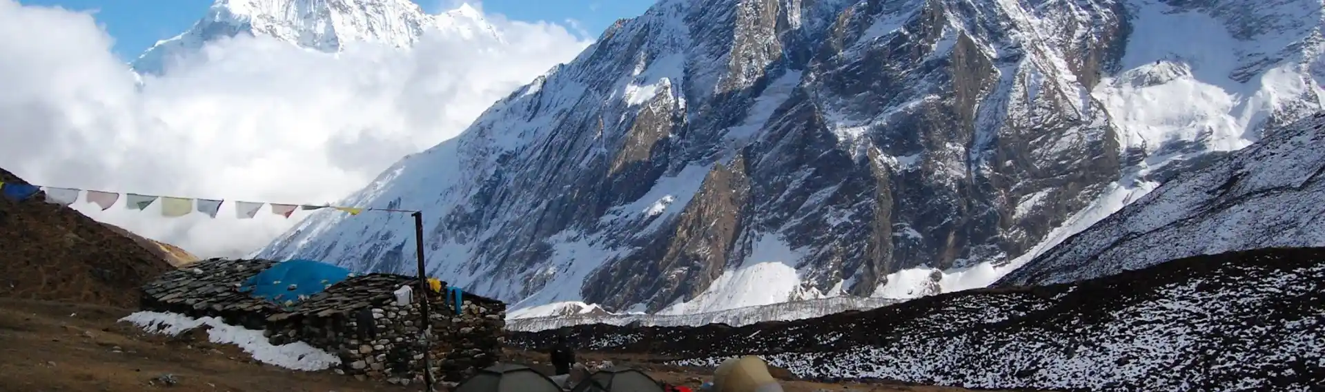
ພູ Manaslu
ການເດີນທາງນີ້ຈະພາທ່ານໄປໃກ້ກັບ ພູທີ່ສູງທີ່ສຸດອັນດັບທີ 8 ໃນໂລກ, ພູເຂົາ Manaslu, 8,163 ແມັດ. ດ້ວຍການຜະຈົນໄພນີ້, ທ່ານຈະໄດ້ຢືນຢູ່ທີ່ຖານຂອງຍອດພູນີ້. ນອກຈາກນັ້ນ, ທ່ານຍັງຈະໄດ້ເປັນພະຍານເຖິງພູເຂົາອື່ນໆເຊັ່ນ: Annapurna, Ganesh Himal, Cheo Himal, ແລະ Ngadi Chili.
Larkya La Pass
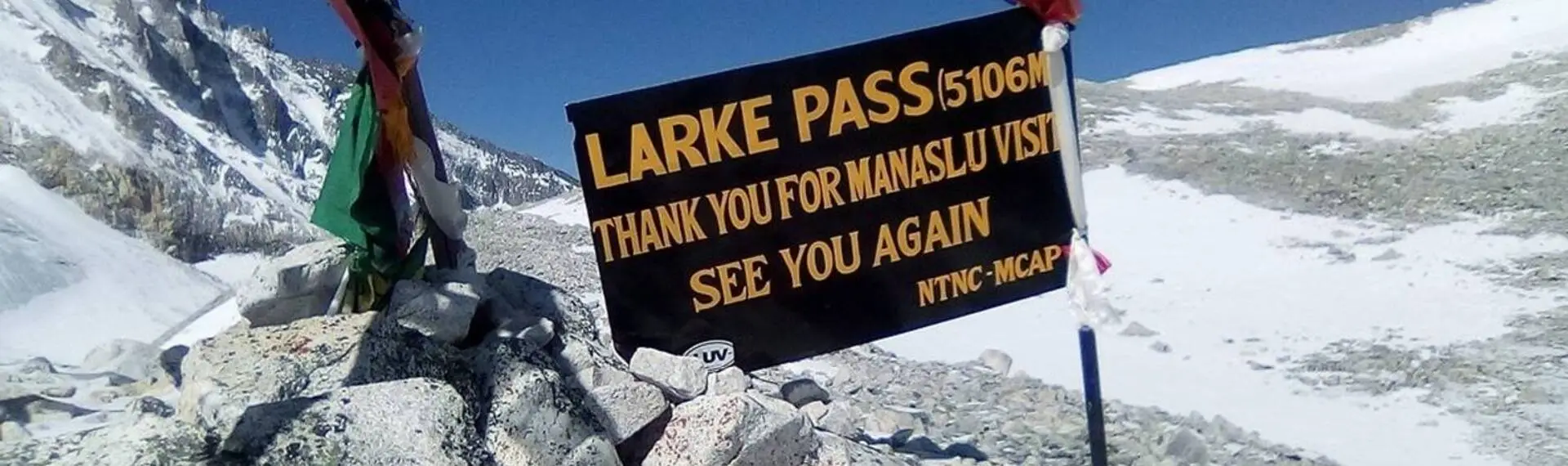
ຊ່ອງທາງ Larkhya La, ທີ່ 5,106 ແມັດ, ເປັນຈຸດສູງສຸດທີ່ທ່ານຈະໄປຮອດໃນການເດີນທາງຄັ້ງນີ້ເມື່ອທ່ານຢືນຢູ່ທີ່ນັ້ນ, ທ່ານຈະໄດ້ເຫັນທິວທັດທີ່ສວຍງາມຂອງເທືອກເຂົາຫິມະໄລ. ມັນຖືວ່າເປັນທາງຜ່ານທີ່ຍາວທີ່ສຸດໃນເທືອກເຂົາຫິມະໄລໃນປະເທດເນປານ, ຕັ້ງຢູ່ລະຫວ່າງ Dharmashala ແລະ Bimthang.
ເຂດອະນຸລັກ Manaslu
ການເດີນທາງຜ່ານເຂດອະນຸລັກ Manaslu. ພື້ນທີ່ດັ່ງກ່າວເປີດໂອກາດໃຫ້ທ່ານໄດ້ເປັນພະຍານເຖິງພືດ ແລະ ສັດທີ່ຫຼາກຫຼາຍຂອງພາກພື້ນ. ທ່ານສາມາດເຫັນສັດປ່າຊະນິດຕ່າງໆເຊັ່ນ: ໝີແພນດ້າແດງ ແລະ ກວາງຫິມະໄລ. ການໄດ້ຮັບໃບອະນຸຍາດເຂດອະນຸລັກ Manaslu ແມ່ນມີຄວາມຈຳເປັນຫຼາຍ ເພາະວ່າການເດີນທາງຜ່ານພື້ນທີ່ນີ້.
ບ້ານພື້ນເມືອງ ແລະ ວັດທະນະທຳ
ທ່ານຈະຜ່ານບ້ານຕ່າງໆເຊັ່ນ: ມັກຊາໂຄລາ, ນ້ຳຣຸງ, ສະມາກອນ, ຊຳໂດ, ບິມຕັງ, ແລະ ອື່ນໆ. ບ້ານເຫຼົ່ານີ້ຊ່ວຍໃຫ້ທ່ານສາມາດເປັນພະຍານເຖິງວັດທະນະທຳ ແລະ ປະເພນີທີ່ໄດ້ຮັບແຮງບັນດານໃຈຈາກທິເບດ. ຜູ້ຄົນຢູ່ທີ່ນີ້ມີຄວາມເປັນມິດ ແລະ ໃຫ້ການຕ້ອນຮັບທີ່ອົບອຸ່ນ ແລະ ເປັນມິດ.
Manaslu Circuit Trek ຍາກປານໃດ?
ເມື່ອປຽບທຽບກັບການຍ່າງປ່າອື່ນໆໃນປະເທດເນປານ, ເສັ້ນທາງ Manaslu Circuit Trek ແມ່ນເປັນເສັ້ນທາງທີ່ຂ້ອນຂ້າງປານກາງly ທ້າທາຍ ການຜະຈົນໄພໃນພູເຂົາຫິມະໄລ. ຄວາມຫ່າງໄກ ຂອງການເດີນທາງ ແລະ ສູງ ສະເໜີສິ່ງທ້າທາຍຫຼາຍຢ່າງໃຫ້ກັບນັກທ່ອງທ່ຽວການສຳເລັດການຍ່າງປ່າຕ້ອງການຄວາມແຂງແຮງທາງຮ່າງກາຍທີ່ດີ, ເພາະວ່າທ່ານຈະຕ້ອງຍ່າງເປັນເວລາຫຼາຍຊົ່ວໂມງຜ່ານເສັ້ນທາງຂຶ້ນເນີນທີ່ຊັນ ແລະ ລົງເນີນ. ເສັ້ນທາງດັ່ງກ່າວປະກອບມີເສັ້ນທາງທີ່ຂຸຂະ, ການຂ້າມແມ່ນ້ຳ, ແລະ ບາງຄັ້ງຄາວກໍ່ເກີດດິນເຈື່ອນ, ເຊິ່ງຮຽກຮ້ອງໃຫ້ມີການສຸມໃສ່ ແລະ ບາດກ້າວທີ່ລະມັດລະວັງ.
ເສັ້ນທາງ Larkya La ທີ່ທ້າທາຍ ເຊິ່ງຕັ້ງຢູ່ທີ່ລະດັບຄວາມສູງ 5160 ແມັດ ກໍ່ຕັ້ງຢູ່ຕາມເສັ້ນທາງເຊັ່ນກັນ. ສ່ວນນີ້ແມ່ນສ່ວນທີ່ຍາກທີ່ສຸດຂອງວົງຈອນ ເນື່ອງຈາກອາກາດບາງ ແລະ ອຸນຫະພູມໜາວເຢັນ. ເຖິງຢ່າງໃດກໍ່ຕາມ, ການປັບຕົວເທື່ອລະກ້າວ ແລະ ການກະກຽມທີ່ເໝາະສົມເຮັດໃຫ້ການເດີນທາງສາມາດຈັດການໄດ້ສຳລັບນັກຍ່າງປ່າສ່ວນໃຫຍ່. ເຖິງວ່າຈະມີຄວາມຫຍຸ້ງຍາກ, ແຕ່ການເດີນທາງເຮັດໃຫ້ຄວາມພະຍາຍາມທຸກຢ່າງຄຸ້ມຄ່າ, ດ້ວຍທິວທັດພູເຂົາທີ່ສວຍງາມ ແລະ ປະສົບການທາງວັດທະນະທຳທີ່ອຸດົມສົມບູນ.
ຄວາມຄິດສຸດທ້າຍ
ທ່ານຄວນກວດສອບແຜນທີ່ Manaslu Circuit Trek ກ່ອນທີ່ຈະເລີ່ມຕົ້ນການຜະຈົນໄພ. ສິ່ງນີ້ຮັບປະກັນວ່າທ່ານມີຂໍ້ມູນດີກ່ຽວກັບພື້ນທີ່ຕ່າງໆ ແລະ ຍັງມີຄວາມຄິດກ່ຽວກັບຄວາມຫຍຸ້ງຍາກທີ່ທ່ານຈະພົບໃນການເດີນທາງ. ສິ່ງນີ້ຊ່ວຍໃຫ້ທ່ານກຽມພ້ອມສຳລັບສິ່ງທ້າທາຍຕ່າງໆ, ດັ່ງນັ້ນຈຶ່ງສະເໜີປະສົບການການຍ່າງປ່າທີ່ປອດໄພ ແລະ ມ່ວນຊື່ນໃນພາກພື້ນ Manaslu. ໃນການຍ່າງປ່ານີ້, ທ່ານບໍ່ພຽງແຕ່ຈະໄດ້ເປັນພະຍານເຖິງຄວາມງາມທາງທຳມະຊາດຂອງເທືອກເຂົາຫິມະໄລເທົ່ານັ້ນ, ແຕ່ຍັງມີໂອກາດໄດ້ສຳຜັດກັບວັດທະນະທຳທີ່ເປັນເອກະລັກຂອງຜູ້ຄົນອີກດ້ວຍ.
ຄໍາຖາມ
ເສັ້ນທາງ Manaslu Circuit ຍາກກວ່າເສັ້ນທາງ Annapurna Circuit ບໍ?
ໂດຍທົ່ວໄປແລ້ວ ການເດີນທາງດ້ວຍເສັ້ນທາງ Manaslu Circuit Trek ແມ່ນມີຄວາມສັບສົນຫຼາຍກວ່າການເດີນທາງດ້ວຍເສັ້ນທາງ Annapurna Circuit Trek. ເສັ້ນທາງຍ່າງປ່າແມ່ນຫ່າງໄກ, ຄົດเคี้ยว, ແລະ ພັດທະນາໜ້ອຍກວ່າ, ມີສິ່ງອຳນວຍຄວາມສະດວກຈຳກັດເມື່ອທຽບກັບ Annapurna. ເສັ້ນທາງ Larkya La Pass ເຊິ່ງມີຄວາມສູງ 5,106 ແມັດ ກໍ່ມີຄວາມທ້າທາຍຫຼາຍກວ່າເສັ້ນທາງ Thorong La Pass ໃນດ້ານພູມສັນຖານ ແລະ ລະດັບຄວາມສູງ.
ການເດີນທາງຜ່ານ Manaslu Circuit ໃຊ້ເວລາດົນປານໃດ?
ການເດີນທາງດ້ວຍເສັ້ນທາງ Manaslu Circuit ໂດຍປົກກະຕິແລ້ວຈະໃຊ້ເວລາ 12 ຫາ 14 ມື້. ໄລຍະທາງທັງໝົດແມ່ນປະມານ 177 ກິໂລແມັດ (110 ໄມລ໌), ຂຶ້ນກັບເສັ້ນທາງທີ່ເດີນທາງ. ໄລຍະເວລາດັ່ງກ່າວລວມມີມື້ປັບຕົວເຂົ້າກັບສະພາບອາກາດໜຶ່ງ ຫຼື ສອງມື້ໃນບ້ານຕ່າງໆເຊັ່ນ Samagaon ຫຼື Samdo.
ຕ້ອງມີໃບອະນຸຍາດຫຍັງແດ່ສຳລັບການຍ່າງປ່າ Manaslu Circuit Trek?
ສຳລັບການເດີນທາງ Manaslu Circuit Trek, ທ່ານຈະຕ້ອງການໃບອະນຸຍາດສາມຢ່າງຄື: ໃບອະນຸຍາດພື້ນທີ່ຈຳກັດ Manaslu (MRAP), ໃບອະນຸຍາດພື້ນທີ່ອະນຸລັກ Manaslu (MCAP), ແລະ ໃບອະນຸຍາດພື້ນທີ່ອະນຸລັກ Annapurna (ACAP). ການມີໃບອະນຸຍາດເຫຼົ່ານີ້ຮັບປະກັນການເດີນທາງທີ່ມີຄວາມຮັບຜິດຊອບໃນພາກພື້ນ Manaslu.
ເວລາໃດດີທີ່ສຸດທີ່ຈະເຮັດ Manaslu Circuit Trek?
ເວລາທີ່ດີທີ່ສຸດສຳລັບການຍ່າງປ່າໃນ Manaslu Circuit ແມ່ນລະດູໃບໄມ້ປົ່ງ (ເດືອນມີນາ ຫາ ພຶດສະພາ) ແລະ ລະດູໃບໄມ້ຫຼົ່ນ (ເດືອນກັນຍາ ຫາ ພະຈິກ). ລະດູການເຫຼົ່ານີ້ມີສະພາບອາກາດທີ່ໝັ້ນຄົງ, ມີທິວທັດພູຜາທີ່ແຈ່ມໃສ, ແລະ ມີເງື່ອນໄຂການຍ່າງປ່າທີ່ສະດວກສະບາຍ. ການຍ່າງປ່າໃນລະດູໜາວ ແລະ ລະດູຝົນແມ່ນເປັນໄປໄດ້, ແຕ່ພວກມັນມາພ້ອມກັບສິ່ງທ້າທາຍເຊັ່ນ: ຫິມະ ແລະ ຝົນ.
ມີທີ່ພັກຕາມເສັ້ນທາງ Manaslu Circuit Trek ບໍ?
ແມ່ນແລ້ວ, ມີຮ້ານນ້ຳຊາ ແລະ ບ້ານພັກຕາມເສັ້ນທາງ, ເຊິ່ງມີອາຫານ ແລະ ທີ່ພັກພື້ນຖານ. ສິ່ງອຳນວຍຄວາມສະດວກແມ່ນງ່າຍດາຍ ແລະ ມີຈຳກັດກວ່າສະຖານທີ່ຕ່າງໆໃນວົງວຽນອັນນາປູນາ. ທ່ານຈະຕ້ອງຈອງລ່ວງໜ້າໃນຊ່ວງລະດູການທ່ອງທ່ຽວສູງສຸດເພື່ອໃຫ້ໄດ້ບ່ອນພັກ.