
27 ມື້
Quick Facts
ການຂົນສົ່ງທາງບົກໃນປະເທດເນປານ
ໂຮງແຮມ ແລະ ທີ່ພັກໃນຮ້ານນ້ຳຊາ
ອາຫານທຸກຄາບຍົກເວັ້ນໃນ Kathmandu
ມີລົດນຳທ່ຽວ ແລະ ຍ່າງປ່າຕະຫຼອດການເດີນທາງ
ລະດູຮ້ອນ, ລະດູໃບໄມ້ປົ່ງ
ປານກາງ
ເນປານ
5,360 m
ກາທະທັມ-ເນປາລັນຈ໌-ຈູປາ-ໂພກສຸນໂດ-ເຊໂກມປາ, ຈູຟານ-ເນປາລັນຈ໌-ກະທັນ.


ເປັນຫຍັງຕ້ອງໄປທ່ຽວ Upper Dolpo Trek?
- ສຳຫຼວດໜຶ່ງໃນພື້ນທີ່ຫ່າງໄກສອກຫຼີກ ແລະ ມີຂໍ້ຈຳກັດທີ່ສຸດຂອງປະເທດເນປານ, ຕັ້ງຢູ່ພາຍໃນ ອຸທະຍານແຫ່ງຊາດ Shey Phoksundo.
- ປະຕິບັດຕາມ ເສັ້ນທາງການຄ້າເກືອບູຮານ ທີ່ເຄີຍເຊື່ອມຕໍ່ເນປານກັບທິເບດ.
- ຜ່ານພູຫິມະໄລສູງ ສູງກວ່າ 5,000 m, ເຊັ່ນວ່າ ເຊ ລາ (5,010 ມ.) ແລະ ຄັງລາ (5,350 ມ).
- ໄປຢ້ຽມຢາມບ້ານຫ່າງໄກສອກຫຼີກເຊັ່ນ Ringmo, Saldang ແລະ Dho Tarap, ບ່ອນທີ່ປະຊາຊົນຍັງປະຕິບັດ ສາສະໜາບອນ.
- ພະຍານ ວັດວາອາຮາມທີ່ມີອາຍຸຫຼາຍສັດຕະວັດ ຄືກັບ Shey Gompa, ມັກຖືກເອີ້ນວ່າ "ວັດຄຣິສຕັລ".
- ຢູ່ໃນ ຮ້ານນ້ຳຊາພື້ນຖານ or ບ່ອນຕັ້ງຄ້າຍ, ຍ້ອນວ່າພາກພື້ນນີ້ມີພື້ນຖານໂຄງລ່າງການທ່ອງທ່ຽວໜ້ອຍທີ່ສຸດ.
- ຄົ້ນພົບວ່າ Upper Dolpo ໄດ້ຮັບນັກທ່ອງທ່ຽວໜ້ອຍກວ່າ 500 ຄົນຕໍ່ປີ, ເຊິ່ງເຮັດໃຫ້ມັນເປັນ ແອອັດຫນ້ອຍ ແລະ ພາກພື້ນທີ່ມີການຍ່າງປ່າໜ້ອຍກວ່າ.
- ຊົມວິວຂອງ ຄານຈິໂຣວາ (6,883 ມ), ເກີນລາກຣີ (8,167 ແມັດ), ແລະ ເປັນຫມັນ ພູພຽງທິເບດ ໃນການສັກຢາຫນຶ່ງ.
ພາບລວມການເດີນທາງ
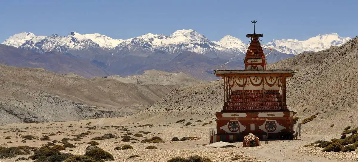
ຖ້າທ່ານຄິດວ່າປະເທດເນປານສິ້ນສຸດຢູ່ທີ່ພູ Everest, ລອງຄິດໃໝ່ອີກຄັ້ງ. ການເດີນທາງ Upper Dolpo ຈະພາທ່ານໄປບ່ອນທີ່ GPS ຢຸດຊອກຫາ. ມັນຂະຫຍາຍໄປທົ່ວ ອຸທະຍານແຫ່ງຊາດ Shey Phoksundo, ບັນລຸລະດັບຄວາມສູງປະມານ 5,050 ແມັດ ທີ່ Nagdalo La HC (ຄ້າຍພັກໄຮ). ພື້ນທີ່ດັ່ງກ່າວເບິ່ງຄືກັບພິພິທະພັນຂອງ ວັດທະນະທຳໂບຮານຂອງທິເບດ ແລະ ພຸດທະສາສະໜາ.
ການເດີນທາງເລີ່ມຕົ້ນທີ່ Kathmandu ດ້ວຍ ຖ້ຽວບິນໄປ Nepalgunj, ຕິດຕາມດ້ວຍກ ຍົນໄປ Juphalຈາກບ່ອນນັ້ນ, ທ່ານຈະເດີນທາງໄປທີ່ ທະເລສາບ Phoksundo ແລະ ຊາລາກາຣີ, ຫຼັງຈາກນັ້ນສືບຕໍ່ໄປ ແຄມສູງເສັ້ນທາງຜ່ານ Shey Gompa, ນຳກຸງ ກອມປາ, ແລະ ນາມໂດ ກ່ອນຂ້າມ ທາຣັບ ໂຄລາ ແລະ ຕາລາໂຄດ. ໃນທີ່ສຸດ, ທ່ານຈະກັບຄືນຜ່ານ Jupal ແລະ Nepalgunj ກັບຄືນໄປ Kathmandu, ສຳເລັດການຂີ່ລົດຖີບຮອບວົງວຽນ.
ທ່ານຈະເຫັນ Dhaulagiri, Kanjirowa, Putha Hiunchuli (7,246 ແມັດ), ຜ່ານໄປຄືກັບ ຄັງລາ (5,306 ແມັດ), ສາລດັງ ລາ (5,200 ແມັດ), ຈາກາ ລາ (5,336 ແມັດ), ແສງດາລາ (5,118 ແມັດ), ແລະ ຕ່ໍາກວ່າ Sangda La (5,125 ແມັດ) ພ້ອມກັບແມ່ນ້ຳຕ່າງໆເຊັ່ນ ໂພສີສັນໂດ ແລະ ທາຣັບ ທີ່ມີການປ່ຽນແປງໜ້ອຍຫຼາຍເປັນເວລາຫຼາຍສັດຕະວັດ. ວັດທະນະທຳ ແລະ ປະເພນີແມ່ນມີຢູ່ທົ່ວທຸກແຫ່ງ. ງານບຸນຕ່າງໆເຊັ່ນ: Chhode ແລະ Lhosar (ສະຫຼອງໃນເດືອນກຸມພາ ຫຼື ເດືອນມີນາ) ເຕັມໄປດ້ວຍພິທີກຳຕ່າງໆໃນໝູ່ບ້ານ. ຊີວິດປະຈຳວັນໝູນວຽນຢູ່ກັບການລ້ຽງສັດຈາກ, ການຄ້າຂາຍເກືອ, ແລະ ພິທີກຳທີ່ມີມາຫຼາຍຮ້ອຍປີ.
ສັດປ່າແມ່ນສ່ວນໜຶ່ງຂອງການເດີນທາງ. ເສືອດາວຫິມະ, ແກະສີຟ້າ, ກວາງ musk, ແລະ ກຣິຟອນຫິມະໄລ ອາໄສຢູ່ທີ່ນີ້. ການເດີນທາງຜ່ານອຸທະຍານແຫ່ງຊາດ Shey Phoksundo (3,555 ກິໂລແມັດມົນທົນ), ເຊິ່ງປົກປ້ອງປ່າໄມ້, ທົ່ງຫຍ້າລ້ຽງສັດເທິງພູສູງ, ແລະ ພື້ນທີ່ຊຸ່ມນ້ຳ. ສະນັ້ນ, ກ້າວເຂົ້າສູ່ໂລກທີ່ຄົນຈຳນວນໜ້ອຍເຫັນ. ຍ່າງຜ່ານຊ່ອງແຄບສູງ, ໄປຢ້ຽມຢາມວັດວາອາຮາມບູຮານ, ແລະ ເບິ່ງຊີວິດການເປັນຢູ່ໃນບ້ານທີ່ຫ່າງໄກ.
ຄ່າໃຊ້ຈ່າຍໃນການເດີນທາງ Upper Dolpo Trek
ການເດີນທາງ Upper Dolpo ມີລາຄາປະມານ ໂດລາ 4,100-7,000, ເຊິ່ງແມ່ນ ໜຶ່ງໃນລາຄາທີ່ແຂ່ງຂັນທີ່ສຸດທີ່ມີຢູ່ ສຳລັບການຜະຈົນໄພທີ່ຫ່າງໄກຈາກພູເຂົາຫິມະໄລນີ້. ອົງການຂອງພວກເຮົາສະເໜີສິ່ງນີ້ເປັນ ຊຸດຫຼຸດລາຄາພິເສດ, ເຊິ່ງເຮັດໃຫ້ມັນ ລາຄາບໍ່ແພງໂດຍບໍ່ຕ້ອງຕັດສິ່ງທີ່ຈຳເປັນອອກລາຄານີ້ຖືກອອກແບບມາເພື່ອໃຫ້ທ່ານ ປະສົບການການເດີນທາງຢ່າງເຕັມທີ່, ລວມທັງຖ້ຽວບິນ, ການຂົນສົ່ງໃນທ້ອງຖິ່ນ, ທີ່ພັກ, ອາຫານ, ໃບອະນຸຍາດ, ຜູ້ນຳທ່ຽວ, ແລະ ຄົນຖືກະເປົາ.
ຄ່າໃຊ້ຈ່າຍກວມເອົາຫຼາຍດ້ານທີ່ສຳຄັນຂອງການເດີນທາງ. ຖ້ຽວບິນພາຍໃນຈາກ Kathmandu ໄປ Nepalgunj ແລະຈາກນັ້ນໄປ Juphal, ເຊິ່ງມັກຈະເປັນຄ່າໃຊ້ຈ່າຍຫຼັກ, ແມ່ນລວມຢູ່. ທີ່ພັກໃນຮ້ານນ້ຳຊາ ຫຼື ຄ້າຍພັກ, ອາຫານພື້ນຖານໃນລະຫວ່າງການຍ່າງປ່າ, ແລະ ການຂົນສົ່ງທີ່ຈຳເປັນທັງໝົດ, ລວມທັງການວາງແຜນສຸກເສີນສຳລັບຄວາມລ່າຊ້າຂອງສະພາບອາກາດ, ກໍ່ລວມຢູ່ນຳ. ນອກຈາກນັ້ນ, ສ່ວນໜຶ່ງຈະຖືກນຳໄປໃຊ້ເປັນຄ່າທຳນຽມການອະນຸລັກສວນສາທາລະນະ ແລະ ການສະໜັບສະໜູນຊຸມຊົນທ້ອງຖິ່ນ, ເຊິ່ງຊ່ວຍອະນຸລັກວັດທະນະທຳ ແລະ ສິ່ງແວດລ້ອມຂອງ Dolpo..
ແຜນການເດີນທາງ Upper Dolpo Trek
ວັນ 01: ມາຮອດ Kathmandu
ການຜະຈົນໄພ Upper Dolpo ຂອງທ່ານເລີ່ມຕົ້ນທັນທີທີ່ທ່ານລົງຈອດທີ່ສະໜາມບິນສາກົນ Tribhuvan ໃນ Kathmandu. ຫຼັງຈາກສຳເລັດການກວດກາພາສີ ແລະ ການເຂົ້າເມືອງແລ້ວ, ຕົວແທນຂອງພວກເຮົາຈະຕ້ອນຮັບທ່ານດ້ວຍ “Namaste” ແບບເນປານທີ່ອົບອຸ່ນ ແລະ ພວງມາລາແບບດັ້ງເດີມ. ຈາກສະໜາມບິນ, ທ່ານຈະຖືກນຳສົ່ງໄປໂຮງແຮມຂອງທ່ານ. ການຂັບລົດນຳສະເໜີໃຫ້ທ່ານເຫັນພາບທຳອິດຂອງຊີວິດຕາມຖະໜົນຫົນທາງຂອງເນປານ: ຮ້ານຂາຍອາຫານຕາມຖະໜົນຫົນທາງ ແລະ ວັດວາອາຮາມຂະໜາດນ້ອຍທີ່ຢູ່ຂ້າງທາງ.
ເມື່ອທ່ານຕັ້ງຖິ່ນຖານຢູ່ໃນໂຮງແຮມແລ້ວ, ມື້ນີ້ແມ່ນເວລາຂອງທ່ານທີ່ຈະພັກຜ່ອນ ຫຼື ສຳຫຼວດຖະໜົນຫົນທາງໃກ້ຄຽງ. ທ່ານອາດຈະໄປຢ້ຽມຢາມຮ້ານກາເຟ ຫຼື ຮ້ານຂາຍເຄື່ອງເພື່ອເພີດເພີນກັບລົດຊາດອາຫານເນປານຄັ້ງທຳອິດຂອງທ່ານ - ບາງທີອາດເປັນ dal bhat ຫຼື ເຂົ້າໜົມປັງ momo. ສິ້ນສຸດມື້ດ້ວຍອາຫານຄ່ຳຕ້ອນຮັບ, ເຊິ່ງມັກຈະມີອາຫານເນປານແບບດັ້ງເດີມ, ແລະ ຕາມດ້ວຍການພັກຄືນທີ່ໂຮງແຮມໃນ Kathmandu.
ຄ່ໍາ
ໂຮງແຮມ
1,300 ມ / 4,265 ຟຸດ
ວັນ 02: ການກະກຽມການທ່ອງທ່ຽວ ແລະ ການເດີນທາງໃນເມືອງ Kathmandu
ມື້ທີສອງຂອງທ່ານໃນ Kathmandu ເລີ່ມຕົ້ນດ້ວຍອາຫານເຊົ້າອຸ່ນໆ. ມື້ນີ້, ທ່ານຈະໄດ້ໄປສຳຫຼວດສະຖານທີ່ມໍລະດົກໂລກຂອງອົງການ UNESCO ຂອງ Kathmandu ເຊິ່ງສະແດງໃຫ້ເຫັນປະຫວັດສາດ ແລະ ສະຖາປັດຕະຍະກຳ. ການເດີນທາງເລີ່ມຕົ້ນທີ່ Swayambhunath Stupa (ວັດລີງ) ຕັ້ງຢູ່ເທິງສຸດຂອງເນີນພູ. ຈາກຈຸດສູງສຸດ, ທ່ານສາມາດເຫັນຮ່ອມພູ Kathmandu ທັງໝົດ. ຫຼັງຈາກນັ້ນ, ທ່ານຈະເດີນທາງໄປທີ່ວັດ Pasupatinath, ເຊິ່ງເປັນສະຖານທີ່ສັກສິດທີ່ສຸດຂອງຊາວຮິນດູທີ່ຕັ້ງຢູ່ແຄມຝັ່ງແມ່ນ້ຳ Bagmati.
ຫຼັງຈາກຮັບປະທານອາຫານທ່ຽງແບບທ້ອງຖິ່ນແລ້ວ, ທ່ານຈະໄດ້ເດີນທາງໄປທີ່ Kathmandu Durbar Square, ບໍລິເວນພະລາຊະວັງບູຮານທີ່ເຄີຍເປັນທີ່ປະທັບຂອງກະສັດ Malla. ຮູບແກະສະຫຼັກໄມ້, ເດີ່ນບ້ານເກົ່າແກ່, ແລະ ທີ່ຢູ່ອາໄສຂອງເທບທິດາ Kumari ທີ່ຍັງມີຊີວິດຢູ່ສະທ້ອນໃຫ້ເຫັນເຖິງວັດທະນະທໍາພື້ນເມືອງຂອງເນປານ.
ຕໍ່ມາໃນຕອນບ່າຍ, ຈຸດສຸມຂອງທ່ານຈະປ່ຽນໄປສູ່ການກະກຽມ. ສະມາຊິກອົງການຂອງພວກເຮົາຈະສຳເລັດເອກະສານທີ່ຈຳເປັນທັງໝົດ, ຍ້ອນວ່າບຸກຄົນບໍ່ສາມາດໄດ້ຮັບສິ່ງເຫຼົ່ານີ້ດ້ວຍຕົວຄົນດຽວ. ຜູ້ນຳທ່ຽວຂອງທ່ານຈະທົບທວນອຸປະກອນທີ່ທ່ານຫຸ້ມຫໍ່ໄວ້. ຖ້າທ່ານຕ້ອງການຊື້ ຫຼື ເຊົ່າສິ່ງໃດກໍ່ຕາມ, ທ່ານສາມາດເຮັດໄດ້ຢູ່ຮ້ານຄ້າໃກ້ຄຽງ. ການຊີ້ແຈງລະອຽດສຸດທ້າຍຈະຢືນຢັນແຜນການເດີນທາງສຳລັບມື້ຕໍ່ໆໄປ, ທົບທວນຂັ້ນຕອນຄວາມປອດໄພ, ແລະ ຢືນຢັນການຈັດການໃນນາທີສຸດທ້າຍ.
ອາຫານເຊົ້າ, ອາຫານທ່ຽງ, ຄ່ໍາ
ໂຮງແຮມ
5-10 ກິໂລແມັດ
1,300 ມ / 4,265 ຟຸດ
ຊົ່ວໂມງ 8-9
ວັນ 03: ບິນຈາກ Kathmandu ໄປ Nepalgunj
ມື້ນີ້, ທ່ານຈະອອກຈາກນະຄອນຫຼວງ ແລະ ບິນໄປທາງທິດຕາເວັນຕົກສູ່ເມືອງ Nepalgunj. ຫຼັງຈາກກິນອາຫານເຊົ້າແຕ່ເຊົ້າ, ທ່ານຈະມຸ່ງໜ້າໄປທີ່ສະໜາມບິນສາກົນ Tribhuvan ພາຍໃນປະເທດ ເພື່ອບິນໄລຍະສັ້ນໄປຍັງເມືອງ Nepalgunj, ເມືອງທີ່ຢູ່ໃກ້ກັບຊາຍແດນອິນເດຍ. ການບິນໃຊ້ເວລາປະມານ 50 ນາທີ, ເຊິ່ງເຮັດໃຫ້ທ່ານເຫັນທິວທັດທາງອາກາດຂອງເນີນພູກາງຂອງປະເທດເນປານ ແລະ ທົ່ງພຽງ Terai. ເມື່ອທ່ານລົງຈອດ, ການປ່ຽນແປງຢ່າງກະທັນຫັນຂອງສະພາບອາກາດແມ່ນຍາກທີ່ຈະພາດ; ອາກາດເຢັນຂອງ Kathmandu ກາຍເປັນລົມພັດທີ່ອົບອຸ່ນ ແລະ ຊຸ່ມຊື່ນຂອງເມືອງ Nepalgunj.
ເມືອງ Nepalgunj ເປັນປະຕູຫຼັກສູ່ພາກຕາເວັນຕົກຂອງເນປານ ແລະ ພາກພື້ນ Dolpo. ຫຼັງຈາກເຊັກອິນເຂົ້າໂຮງແຮມແລ້ວ, ທ່ານຈະມີເວລາພັກຜ່ອນ ແລະ ສຳຫຼວດພື້ນທີ່ທ້ອງຖິ່ນ. ທ່ານສາມາດໄປຢ້ຽມຢາມສວນສັດຂະໜາດນ້ອຍ, ວັດ Bageshwori, ຫຼື ພຽງແຕ່ຍ່າງຕາມຖະໜົນຫົນທາງ. ໃນຕອນແລງ, ຜູ້ນຳທ່ຽວຂອງທ່ານຈະໃຫ້ຄຳແນະນຳສັ້ນໆກ່ຽວກັບຖ້ຽວບິນມື້ອື່ນໄປຍັງສະໜາມບິນພູເຂົາ Juphal, ເຊິ່ງເປີດປະຕູສູ່ Upper Dolpo.
ອາຫານເຊົ້າ, ອາຫານທ່ຽງ, ຄ່ໍາ
ຮ້ານຊາ
519 km
150 ມ / 492 ຟຸດ
50 ນາທີ
ວັນ 04: ບິນໄປ Juphal ແລະ ຍ່າງປ່າໄປ Dunai
ເຊົ້າມື້ນີ້ເລີ່ມຕົ້ນດ້ວຍອາຫານເຊົ້າແຕ່ເຊົ້າ ແລະ ຖ້ຽວບິນໄລຍະສັ້ນຈາກ Nepalgunj ໄປ Juphal. ຖ້ຽວບິນນີ້ແມ່ນສ່ວນສຳຄັນຂອງປະສົບການ ເພາະມັນສະເໜີທິວທັດທີ່ສວຍງາມຂອງເທືອກເຂົາ Dhaulagiri ແລະ Annapurna ໃນຂະນະທີ່ທ່ານກຳລັງຫັນປ່ຽນຈາກພາກພື້ນ Terai ທີ່ຮາບພຽງໄປສູ່ເທືອກເຂົາຫິມະໄລ. ມັນມີສະໜາມບິນຫີນ, ແລະ ຖ້ຽວບິນມັກຈະຖືກກຳນົດໄວ້ໃນຕອນເຊົ້າເນື່ອງຈາກສະພາບລົມ. ຢູ່ທີ່ນີ້, ທ່ານຈະໄດ້ພົບກັບທີມງານຍ່າງປ່າທີ່ເຫຼືອຂອງທ່ານ.
ຂາທຳອິດຂອງການເດີນທາງເລີ່ມຕົ້ນຈາກ Juphal. ເສັ້ນທາງຍ່າງຜ່ານທົ່ງນາຂັ້ນໄດ ແລະ ບ້ານທ້ອງຖິ່ນບ່ອນທີ່ທ່ານສາມາດສັງເກດເບິ່ງຊີວິດປະຈຳວັນຂອງຄົນທ້ອງຖິ່ນ. ທ່ານຈະຍ່າງຕາມເສັ້ນທາງນ້ອຍໆທີ່ນຳໄປສູ່ແມ່ນ້ຳ Thulo Bheri. ການຍ່າງແມ່ນຂ້ອນຂ້າງງ່າຍ ແລະ ເປັນວິທີທີ່ດີສຳລັບການອຸ່ນເຄື່ອງ ແລະ ປັບຕົວເຂົ້າກັບພື້ນທີ່.
ໃນຕອນບ່າຍ, ທ່ານຈະໄປຮອດ Dunai, ສຳນັກງານໃຫຍ່ຂອງເມືອງ Dolpo. Dunai ເປັນເມືອງທີ່ໃຫຍ່ທີ່ສຸດໃນພາກພື້ນ, ເຊິ່ງປະກອບດ້ວຍຫ້ອງການຂອງລັດຖະບານ, ຈຸດກວດກາຕຳຫຼວດ, ແລະຮ້ານຄ້າຂະໜາດນ້ອຍ. ທ່ານຈະຕັ້ງຄ້າຍພັກແຮມ ແລະ ສະຫຼຸບມື້ທຳອິດຂອງການຍ່າງປ່າໃນພາກພື້ນ Dolpo.
ອາຫານເຊົ້າ, ອາຫານທ່ຽງ, ຄ່ໍາ
Camping
381 km
2,140 ມ / 7,021 ຟຸດ
35 ນາທີ (ການບິນ) | 2-3 ຊົ່ວໂມງ (ການເດີນທາງ)
ວັນ 05: Trek ໄປ Chhepka
ມື້ຍ່າງປ່າເຕັມມື້ທຳອິດຂອງທ່ານເລີ່ມຕົ້ນດ້ວຍອາກາດສົດຊື່ນຕອນເຊົ້າ. ຫຼັງຈາກອາຫານເຊົ້າຢູ່ Dunai, ທ່ານຈະເລີ່ມຍ່າງໄປທາງທິດເໜືອຕາມແຄມຝັ່ງແມ່ນ້ຳ Phoksundo (ແມ່ນ້ຳ Suligad). ຫຼັງຈາກຍ່າງປ່າໄລຍະສັ້ນໆ, ທ່ານຈະໄປຮອດອຸທະຍານແຫ່ງຊາດ Shey Phoksundo, ເຊິ່ງເປັນອຸທະຍານແຫ່ງຊາດທີ່ໃຫຍ່ທີ່ສຸດໃນປະເທດເນປານ. ທີ່ນີ້, ໃບອະນຸຍາດຂອງທ່ານຈະຖືກກວດສອບຢູ່ທີ່ຫ້ອງການອຸທະຍານກ່ອນທີ່ເສັ້ນທາງຈະເຂົ້າໄປໃນປ່າເລິກລົງໄປ.
ເສັ້ນທາງປີນຂຶ້ນໄປສູ່ບ້ານ Magar ແລະ Thakuri, ບ່ອນທີ່ເຮືອນຖືກສ້າງດ້ວຍຫີນແລະໄມ້, ແລະປະຊາຊົນຍັງຄົງດຳລົງຊີວິດແບບດັ້ງເດີມ. ໃນຕອນບ່າຍ, ທ່ານຈະໄປຮອດບ້ານ Chhepka, ເຊິ່ງຖືກອ້ອມຮອບດ້ວຍປ່າໄມ້ແລະທົ່ງນາຂັ້ນໄດ. ທ່ານສາມາດສຳຫຼວດທົ່ງນາ ຫຼື ສົນທະນາກັບຄົນທ້ອງຖິ່ນທີ່ມີຊື່ສຽງໃນການຕ້ອນຮັບທີ່ອົບອຸ່ນ ແລະ ເລື່ອງລາວກ່ຽວກັບຮ່ອມພູເທິງ.
ອາຫານເຊົ້າ, ອາຫານທ່ຽງ, ຄ່ໍາ
ຮ້ານຊາ
19 km
2,838 ມ / 9,311 ຟຸດ
ຊົ່ວໂມງ 6-7
ວັນ 06: ເດີນທາງໄປ Chunuwar
ຫຼັງຈາກໄດ້ພັກຄືນຢູ່ Chhepka, ທ່ານຈະສືບຕໍ່ຍ່າງຕາມແມ່ນ້ຳ Phoksundo ໄປສູ່ເຂດແດນທີ່ຫ່າງໄກກວ່າໃນມື້ນີ້. ການເດີນທາງຈະກາຍເປັນເສັ້ນທາງທີ່ຊັນຂຶ້ນຢ່າງເຫັນໄດ້ຊັດໃນພາກສ່ວນຕ່າງໆ, ໂດຍມີການປີນຂຶ້ນທີ່ທ້າທາຍຫຼາຍຂຶ້ນເມື່ອທຽບກັບມື້ກ່ອນ. ທ່ານຈະໄດ້ຍ່າງຜ່ານປ່າທີ່ໜາແໜ້ນຂອງຕົ້ນ cedar, ຕົ້ນ fir, ແລະຕົ້ນສົນ, ແລະທິວທັດຈະກາຍເປັນປ່າດົງດິບ ແລະ ມີການຜະຈົນໄພຫຼາຍຂຶ້ນດ້ວຍຮູບແບບຫີນ ແລະ ນ້ຳຕົກຕາດຕາມທາງ.
ທ່ານຈະຜ່ານທາງແຍກເສັ້ນທາງນ້ອຍໆ ແລະ ຮ້ານນ້ຳຊາຢູ່ເມືອງເຣຊີ ເຊິ່ງເປັນຈຸດຢຸດພັກທົ່ວໄປ. ຈຸດໝາຍປາຍທາງແມ່ນຢູ່ໃກ້ກັບຄລີນິກສຸຂະພາບພື້ນເມືອງທ້ອງຖິ່ນ (ໂຮງໝໍອຳຈິ), ຊຶ່ງເປັນວິທີທີ່ສະຖານທີ່ດັ່ງກ່າວໄດ້ຮັບຊື່ນີ້ບາງຄັ້ງ. ໃນຕອນບ່າຍ, ທ່ານຈະໄປຮອດເມືອງຈູນູວາ, ຈຸດຢຸດພັກໃກ້ກັບຈຸດທີ່ແມ່ນ້ຳພອກຊຸນໂດ ແລະ ພູງໂມ ໂຄລາ ມາบรรจบກັນ. ທ່ານຈະພັກຄືນຢູ່ທີ່ນີ້.
ອາຫານເຊົ້າ, ອາຫານທ່ຽງ, ຄ່ໍາ
ຮ້ານຊາ
17 km
3,120 ມ / 10,236 ຟຸດ
ຊົ່ວໂມງ 6-7
ວັນ 07: Trek ກັບ Phoksundo Lake
ໃນເບື້ອງຕົ້ນເສັ້ນທາງຈະປີນຂຶ້ນຜ່ານປ່າໄມ້ birch ແລະ cedar, ໂດຍມີທິວທັດທີ່ເປີດອອກເມື່ອທ່ານຂຶ້ນໄປສູງ. ສ່ວນສຸດທ້າຍຈະນຳສະເໜີພາບທຳອິດຂອງທ່ານກ່ຽວກັບທະເລສາບ Phoksundo. ທ່ານຈະຜ່ານນ້ຳຕົກທີ່ສູງທີ່ສຸດຂອງປະເທດເນປານ, ນ້ຳຕົກ Jharana (ຫຼື Suligad), ເຊິ່ງໄຫຼລົງສູ່ແມ່ນ້ຳທາງລຸ່ມສູງກວ່າ 167 ແມັດ.
ຫຼັງຈາກນັ້ນ, ເສັ້ນທາງຍ່າງຈະລົງຜ່ານປ່າ birch ໄປຫາບ້ານ Bon ແບບດັ້ງເດີມຂອງ Ringmo, ຕັ້ງຢູ່ເທິງເຂື່ອນດິນເຈື່ອນຢູ່ທາງທິດໃຕ້ສຸດຂອງທະເລສາບ. ຈາກບ່ອນນີ້, ການຍ່າງໄລຍະສັ້ນໆຈະພາທ່ານໄປສູ່ຊາຍຝັ່ງທະເລສາບ Phoksundo. ທ່ານຈະຕັ້ງຄ້າຍພັກ ແລະ ພັກຜ່ອນໃນຂະນະທີ່ຊົມເຊີຍຄວາມງາມທີ່ງຽບສະຫງົບຂອງທະເລສາບ.
ອາຫານເຊົ້າ, ອາຫານທ່ຽງ, ຄ່ໍາ
Camping
7 km
3,611 ມ / 11,847 ຟຸດ
ຊົ່ວໂມງ 3-4
ວັນ 08: ມື້ປັບສະພາບໃຫ້ເຂົ້າກັບສະພາບອາກາດທີ່ທະເລສາບ Phoksundo
ມື້ນີ້ແມ່ນມື້ປັບຕົວ ແລະ ພັກຜ່ອນຢູ່ທະເລສາບ Phoksundo. ເປັນການພັກຜ່ອນທີ່ຈຳເປັນກ່ອນທີ່ທ່ານຈະອອກເດີນທາງໄປສູ່ເຂດທີ່ສູງຂຶ້ນ ແລະ ຫ່າງໄກສອກຫຼີກກວ່າຂອງ Upper Dolpo. ແຕ່ມັນບໍ່ແມ່ນມື້ທີ່ຂີ້ຄ້ານ. ສິ່ງທຳອິດທີ່ທ່ານສາມາດເຮັດໄດ້ຄືການໄປຢ້ຽມຢາມບ້ານ Ringmo ແບບດັ້ງເດີມຂອງທິເບດ. ທ່ານສາມາດສັງເກດເບິ່ງວິຖີຊີວິດທ້ອງຖິ່ນ, ເຮືອນແບບດັ້ງເດີມ, ແລະ ທົ່ງນາຂັ້ນໄດຢູ່ທີ່ນັ້ນ.
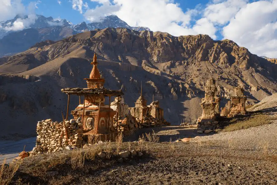
ທ່ານຍັງສາມາດຍ່າງປ່າໄປຍັງວັດບອນໂຊວາບູຮານ ເຊິ່ງຕັ້ງຢູ່ເທິງສັນເຂົາທີ່ມອງເຫັນທະເລສາບໄດ້. ວັດອາຍຸ 900 ປີແຫ່ງນີ້ສະເໜີໃຫ້ເຫັນເຖິງວັດທະນະທຳບອນໂປ, ສາສະໜາທິເບດກ່ອນພຸດທະສາສະໜາ, ແລະ ທິວທັດທີ່ສວຍງາມຂອງພື້ນທີ່ ແລະ ເທວະສະຖານຄັນຈິໂຣວາ.
ໃຊ້ມື້ນີ້ເພື່ອຖ່າຍພາບທິວທັດ, ນັ່ງສະມາທິ, ຫຼືພຽງແຕ່ພັກຜ່ອນຢູ່ສະຖານທີ່ຕັ້ງແຄ້ມ. ມັນເປັນມື້ທີ່ສົມບູນແບບສຳລັບການຟື້ນຕົວ, ຄິດໄຕ່ຕອງ, ແລະກຽມພ້ອມສຳລັບໄລຍະຕໍ່ໄປຂອງການເດີນທາງຂອງທ່ານ.
ອາຫານເຊົ້າ, ອາຫານທ່ຽງ, ຄ່ໍາ
Camping
0 km
3,611 ມ / 11,847 ຟຸດ
ຊົ່ວໂມງ 0
ວັນ 09: Trek ກັບ Sallaghari
ການປ່ຽນແປງລະດັບຄວາມສູງໃນມື້ນີ້ແມ່ນມີໜ້ອຍທີ່ສຸດໃນການເພີ່ມຂຶ້ນສຸດທິ (ສູງກວ່າທະເລສາບພຽງແຕ່ 8-9 ແມັດເທົ່ານັ້ນ), ແຕ່ເສັ້ນທາງມີການຂຶ້ນໆລົງໆຢ່າງຫຼວງຫຼາຍ. ພາກສ່ວນນີ້ຖືວ່າເປັນໜຶ່ງໃນພາກສ່ວນທີ່ໜ້າຕື່ນເຕັ້ນ ແລະ ທ້າທາຍທີ່ສຸດຂອງການເດີນທາງ ຍ້ອນວ່າມັນເປັນຮູບຊົງຂອງຝັ່ງຕາເວັນຕົກຂອງທະເລສາບ Phoksundo. ມັນຕ້ອງການການຍ່າງຢ່າງລະມັດລະວັງໃນຂະນະທີ່ທ່ານຜ່ານໜ້າຜາຫຼາຍພາກສ່ວນ. ທີມງານຂອງພວກເຮົາຍັງຈະຢູ່ທີ່ນັ້ນເພື່ອຊ່ວຍທ່ານໃນພາກສ່ວນທີ່ທ້າທາຍກວ່າ.
ຫຼັງຈາກຍ່າງປ່າປະມານໜຶ່ງຊົ່ວໂມງ, ທ່ານຈະໄປຮອດ Sallaghari, ເຊິ່ງແປຕາມຕົວອັກສອນວ່າ "ປ່າສົນ". ບ່ອນຕັ້ງແຄ້ມແຫ່ງນີ້ແມ່ນພື້ນທີ່ຮາບພຽງຂະໜາດນ້ອຍຕັ້ງຢູ່ໃນປ່າສົນ ຫຼື ຕົ້ນຈູນິເປີ ຢູ່ທາງທິດເໜືອສຸດຂອງທະເລສາບ. ທ່ານຈະໄດ້ພັກຜ່ອນຢູ່ໃນຄ້າຍ Sallaghari, ພ້ອມທີ່ຈະສືບຕໍ່ໄປສູ່ພາກພື້ນ Dolpo ເທິງໃນມື້ຕໍ່ມາ.
ອາຫານເຊົ້າ, ອາຫານທ່ຽງ, ຄ່ໍາ
Camping
11 km
3,620 ມ / 11,877 ຟຸດ
ຊົ່ວໂມງ 5-6
ວັນ 10: ເດີນທາງໄປ Nagdalo La HC
ການເດີນທາງອອກຈາກພື້ນທີ່ທະເລສາບທົ່ວໄປ ແລະ ມຸ່ງໜ້າໄປສູ່ຮ່ອມພູນ້ຳກ້ອນແຄບໆ. ເສັ້ນທາງດັ່ງກ່າວຕິດຕາມເສັ້ນທາງຂອງແມ່ນ້ຳ Tuk Kyaksa Khola (ແມ່ນໍ້າ), ຜ່ານປ່າໄມ້ບາງຕອນຕາມທາງ. ພູມສັນຖານເລີ່ມປ່ຽນຈາກປ່າສົນທີ່ອຸດົມສົມບູນໄປສູ່ພື້ນທີ່ທີ່ຫາຍາກ, ແຫ້ງແລ້ງ ແລະ ເປັນຫີນທີ່ມີພຸ່ມໄມ້ຫຼາຍຂຶ້ນເມື່ອທ່ານຂຶ້ນໄປສູງ.
ດ້ວຍການຍ່າງປ່າ 6-7 ຊົ່ວໂມງຕໍ່ມື້, ທ່ານຈະໄປຮອດ Phoksundo Bhanjyang, ເຊິ່ງເອີ້ນກັນວ່າຄ້າຍພັກ Nagdalo La High Camp ຫຼື ຄ້າຍພັກ Kang La. ທີມງານຂອງພວກເຮົາຈະຕັ້ງຄ້າຍທັນທີຫຼັງຈາກພວກເຂົາມາຮອດທີ່ນັ້ນ. ບ່ອນຕັ້ງຄ້າຍທີ່ຕັ້ງຢູ່ໃນຍຸດທະສາດແຫ່ງນີ້ແມ່ນຈຸດຢືນທີ່ສຳຄັນທີ່ຕັ້ງຢູ່ທາງລຸ່ມຂອງຊ່ອງ Kang La (Nagdalo La) ທີ່ທ້າທາຍທີ່ທ່ານຈະຂ້າມໃນມື້ທີ 11.
ອາຫານເຊົ້າ, ອາຫານທ່ຽງ, ຄ່ໍາ
Camping
10 km
4,700 ມ / 15,420 ຟຸດ
ຊົ່ວໂມງ 5-6
ວັນ 11: Trek ໄປ Shey Gompa ຜ່ານ Nagdalo La Pass
ທ່ານຈະໄດ້ຮັບສ່ວນໜຶ່ງທີ່ທ້າທາຍທີ່ສຸດຂອງການເດີນທາງໃນມື້ນີ້ຄື: ຂ້າມຜ່ານຊ່ອງເຂົາ Nagdalo La ທີ່ສູງ (5,360 ແມັດ). ມື້ເລີ່ມຕົ້ນແຕ່ເຊົ້າເພື່ອຍ່າງຜ່ານເສັ້ນທາງທີ່ຂຸຂະ ແລະ ອາດຈະມີຫິມະຕົກ. ເລີ່ມຕົ້ນຈາກຄ່າຍສູງທີ່ Phoksundo Bhanjyang, ທ່ານຈະຕ້ອງປີນຂຶ້ນຫຼາຍຊົ່ວໂມງເພື່ອໄປຮອດຊ່ອງເຂົາ.
ຊ່ອງຜ່ານນີ້ຍັງເປັນທີ່ຮູ້ຈັກກັນໃນນາມ Kang La. ຈາກຈຸດສູງສຸດຂອງມັນ, ທ່ານສາມາດເຫັນພາກພື້ນ Dolpo ທັງໝົດ, ລວມທັງພູ Crystal (Shey Shikhar), ແລະທົ່ງພຽງສູງທິເບດ. ເສັ້ນທາງຍ່າງອີກຟາກໜຶ່ງຂອງຊ່ອງຜ່ານກໍ່ມີຄວາມທ້າທາຍເທົ່າທຽມກັນ. ທ່ານຈະຕ້ອງລົງໄປຕາມເນີນພູກ່ອນທີ່ຈະໄປຮອດທົ່ງຫຍ້າທີ່ມີຫຍ້າຂຽວອຸ່ມທຸ່ມ. ໄລຍະສຸດທ້າຍຂອງການເດີນທາງຈະນຳພາທ່ານໄປສູ່ພື້ນທີ່ Shey Gompa, ເຊິ່ງເປັນທີ່ຮູ້ຈັກກັນໃນນາມວັດ Crystal. ວັດແຫ່ງນີ້ມີການເຊື່ອມຕໍ່ຢ່າງເລິກເຊິ່ງກັບປະເພນີຂອງທັງ Bon ແລະພຸດທະສາສະໜາທິເບດ.
ອາຫານເຊົ້າ, ອາຫານທ່ຽງ, ຄ່ໍາ
Camping
17 km
4,390 ມ / 14,403 ຟຸດ
ຊົ່ວໂມງ 6-7
ວັນ 12: Trek to Namgung Gompa ຜ່ານ Sela La Pass
ມື້ທີ່ສູງສົ່ງ ແລະ ເປັນແຮງບັນດານໃຈອີກມື້ໜຶ່ງເລີ່ມຕົ້ນເມື່ອທ່ານອອກຈາກ Shey Gompa. ການເດີນທາງເລີ່ມຕົ້ນດ້ວຍການຕິດຕາມ Sephu Khola (ລຳນ້ຳ) ສອງສາມຊົ່ວໂມງກ່ອນທີ່ທ່ານຈະເລີ່ມປີນຂຶ້ນໄປຫາຊ່ອງເຂົາ. ຈາກຍອດ Sela La ໄປທາງທິດເໜືອ, ທ່ານສາມາດເຫັນພູມສັນຖານຂອງທົ່ງພຽງສູງທິເບດ, ໄປທາງທິດຕາເວັນອອກ, ພາກພື້ນ Mustang ສາມາດເຫັນໄດ້ພ້ອມກັບຍອດ Kanjirowa, Kagmara, ແລະ Crystal Mountain.
ຫຼັງຈາກຊົມວິວທິວທັດແລ້ວ, ທ່ານຈະໄດ້ລົງໄປຢ່າງຍາວນານໃນຮ່ອມພູຕໍ່ໄປ ເຊິ່ງສະແດງໃຫ້ເຫັນກະຕູບຫີນທີ່ກະແຈກກະຈາຍ ແລະ ລົດເຮືອນຂອງຊາວຢາກ. ຈາກບ່ອນນັ້ນ, ທ່ານຈະໄປຮອດ Namgung Gompa ເຊິ່ງສ້າງດ້ວຍຫີນສີແດງ. ມັນເປັນໜຶ່ງໃນສະຖານທີ່ທາງສາສະໜາທີ່ໂດດດ່ຽວຂອງ Dolpo ເຊິ່ງເປັນບ້ານຂອງພະສົງທີ່ດຳລົງຊີວິດແບບງ່າຍໆທີ່ອຸທິດຕົນໃຫ້ກັບການນັ່ງສະມາທິ ແລະ ການອະທິຖານ.
ອາຫານເຊົ້າ, ອາຫານທ່ຽງ, ຄ່ໍາ
Camping
12 km
4,430 ມ / 14,534 ຟຸດ
ຊົ່ວໂມງ 5-6
ວັນ 13: ເດີນທາງໄປ Namduna Gaun
ການເດີນທາງໃນມື້ນີ້ມີລະດັບຄວາມສູງຫຼຸດລົງເລັກນ້ອຍ, ຈາກ Namgung Gompa ລົງໄປຫາ Namduna Gaun. ເສັ້ນທາງດັ່ງກ່າວເປັນໄປຕາມເສັ້ນທາງຂອງຫ້ວຍນ້ຳນ້ອຍໆ, ແຕ່ມັນບໍ່ແມ່ນການຍ່າງທີ່ຮາບພຽງ. ທ່ານຈະໄດ້ຍ່າງເທິງພູມສັນຖານທີ່ມີຝຸ່ນ, ເປົ່າປ່ຽວ ແລະ ແຫ້ງແລ້ງທີ່ຄ້າຍຄືກັບທົ່ງພຽງສູງທິເບດ. ພູມສັນຖານມີເນີນພູທີ່ແຫ້ງແລ້ງ ແລະ ພືດພັນທີ່ຫາຍາກ, ສະແດງໃຫ້ເຫັນວ່າ Upper Dolpo ຢູ່ໃນພາກພື້ນທີ່ແຫ້ງແລ້ງ ແລະ ມີຮົ່ມຝົນ.
ໃນຂະນະທີ່ທ່ານຍ່າງ, ທ່ານຈະຜ່ານ chortens ແລະ ກຳແພງ mani ຫຼາຍແຫ່ງ, ເຊິ່ງຊີ້ບອກເຖິງການມີຢູ່ຂອງພຸດທະສາສະໜາທິເບດ ແລະ ວັດທະນະທຳ Bon. ພູມສັນຖານທີ່ເປີດກວ້າງສະໜອງໂອກາດໃນການສັງເກດເບິ່ງສັດປ່າທ້ອງຖິ່ນ, ເຊັ່ນ: ແກະສີຟ້າ, ໝາມາມັອດ ແລະ ນົກລ່າສັດຫຼາຍຊະນິດທີ່ອາໄສຢູ່ໃນລະດັບສູງ.
ຈຸດໝາຍປາຍທາງແມ່ນບ້ານນ້ອຍໆແບບດັ້ງເດີມທີ່ມີເຮືອນຫີນຫຼັງຄາຮາບພຽງຕັ້ງຢູ່ຮ່ວມກັນ. ຈຸດເດັ່ນຂອງບ້ານແມ່ນວັດ Namduna, ເຊິ່ງເປັນວັດບູຮານທີ່ເປັນສະຖານທີ່ສຳຄັນທາງວັດທະນະທຳໃນພາກພື້ນ. ທ່ານຈະຕັ້ງຄ້າຍພັກຢູ່ໃກ້ໆບ້ານ ແລະ ໃຊ້ເວລາສຳຫຼວດວັດບູຮານເພື່ອຜ່ອນຄາຍຄວາມຕຶງຄຽດ.
ອາຫານເຊົ້າ, ອາຫານທ່ຽງ, ຄ່ໍາ
Camping
10 km
4,200 ມ / 13,780 ຟຸດ
ຊົ່ວໂມງ 5-6
ວັນ 14: ການຍ່າງປ່າມື້ໜຶ່ງໄປບ້ານ Saldang
ການເດີນທາງໃນມື້ນີ້ປະກອບມີການປີນພູ ແລະ ຕິດຕາມດ້ວຍການລົງໄປໃນແມ່ນ້ຳ Namga Khola. ຫຼັງຈາກອອກຈາກ Namduna Gaun, ເສັ້ນທາງຈະປີນຂຶ້ນເນີນພູທີ່ແຫ້ງແລ້ງເປັນເວລາຫຼາຍຊົ່ວໂມງ. ເມື່ອທ່ານໄປຮອດຈຸດສູງສຸດ, ທ່ານຈະເຫັນບ້ານ Saldang ກະຈາຍຢູ່ເທິງທົ່ງພຽງທາງລຸ່ມ. ສ່ວນສຸດທ້າຍຂອງການເດີນທາງແມ່ນການລົງໄປຫາບ້ານ.
ບ້ານ Saldang ເປັນບ້ານທີ່ໃຫຍ່ທີ່ສຸດໃນເຂດ Dolpo ພາຍໃນ, ມີປະມານ 80 ຄົວເຮືອນທີ່ມີການກໍ່ສ້າງດີ ແລະ ມີປະຊາກອນປະມານ 600 ຄົນ. ບ້ານດັ່ງກ່າວໄດ້ຮັບອິດທິພົນຢ່າງຫຼວງຫຼາຍຈາກວັດທະນະທໍາທິເບດ, ຕັ້ງແຕ່ສະຖາປັດຕະຍະກໍາຈົນເຖິງພາສາ ແລະ ການແຕ່ງກາຍຂອງຊາວທ້ອງຖິ່ນ. ຕັ້ງຢູ່ເທິງເສັ້ນທາງການຄ້າໄປສູ່ທິເບດ, Saldang ເປັນສູນກາງການກະສິກໍາ ແລະ ການຄ້າທີ່ຈະເລີນຮຸ່ງເຮືອງມາເປັນເວລາຫຼາຍສັດຕະວັດແລ້ວ.
ອາຫານເຊົ້າ, ອາຫານທ່ຽງ, ຄ່ໍາ
Camping
12 km
3,700 ມ / 12,139 ຟຸດ
ຊົ່ວໂມງ 5-6
ວັນ 15: ເດີນທາງໄປບ້ານຢາງເຊ
ໃນມື້ນີ້, ທ່ານຈະໄດ້ຍ່າງປ່າໄປສູ່ພູມສັນຖານທີ່ສູງ ແລະ ແຫ້ງແລ້ງຂອງ Upper Dolpo, ເຄື່ອນທີ່ໄປທາງທິດເໜືອຈາກ Saldang ເພື່ອໄປຮອດ Yangze Gompa. ເສັ້ນທາງດັ່ງກ່າວຈະຕາມລຳດັບດ້ວຍແມ່ນ້ຳ Nagon Khola ໄປທາງທິດເໜືອ. ທ່ານຈະຜ່ານບ້ານນ້ອຍໆ ແລະ ໂດດດ່ຽວກວ່າຂອງບ້ານ Marang ແລະ Ki ຕາມທາງ. ການເດີນທາງຍັງກ່ຽວຂ້ອງກັບການຂ້າມສາຂາຂອງແມ່ນ້ຳ Panzang ກ່ອນທີ່ທ່ານຈະໄປຮອດ Yangze Gompa.
ພື້ນທີ່ດັ່ງກ່າວຕັ້ງຊື່ຕາມວັດວາອາຮາມບອນເກົ່າທີ່ຕັ້ງຢູ່ທີ່ນັ້ນ. ທ່ານຈະມີໂອກາດໄດ້ສຳຫຼວດໜຶ່ງໃນພື້ນທີ່ທີ່ມີຄົນໄປຢ້ຽມຢາມໜ້ອຍທີ່ສຸດຂອງປະເທດເນປານ ແລະ ວັດທະນະທຳບອນແບບດັ້ງເດີມ. ຕອນແລງຢູ່ທີ່ນີ້ມີຄວາມສະຫງົບສຸກ, ເປັນໂອກາດໃຫ້ທ່ານໄດ້ພັກຜ່ອນ ແລະ ກຽມຕົວທາງດ້ານຈິດໃຈ ແລະ ຮ່າງກາຍສຳລັບຂັ້ນຕອນຕໍ່ໄປຂອງການຍ່າງປ່າຂອງທ່ານໄປສູ່ເສັ້ນທາງສູງ ແລະ ໝູ່ບ້ານທີ່ຫ່າງໄກກວ່າ.
ອາຫານເຊົ້າ, ອາຫານທ່ຽງ, ຄ່ໍາ
Camping
15 km
3,980 ມ / 13,058 ຟຸດ
ຊົ່ວໂມງ 6-7
ວັນ 16: ເດີນທາງໄປບ້ານນຳໂດ
ຫຼັງຈາກພັກຢູ່ທີ່ແມ່ນ້ຳຢາງເຊ ກອມປາ ທີ່ຫ່າງໄກ, ການເດີນທາງຂຶ້ນພູໂດລໂປຕອນເທິງໃນມື້ນີ້ ຈຳເປັນຕ້ອງໄດ້ປ່ຽນທິດທາງເພື່ອສືບຕໍ່ໄປສູ່ຈຸດຢຸດຕໍ່ໄປຂອງການເດີນທາງ. ແທນທີ່ຈະກ້າວໄປທາງທິດເໜືອ, ທ່ານຈະຍ່າງກັບຄືນໄປທາງທິດໃຕ້ກ່ອນທີ່ຈະມຸ່ງໜ້າໄປທາງທິດຕາເວັນອອກໄປສູ່ບ້ານນຳໂດ. ຈາກບ່ອນນັ້ນ, ເສັ້ນທາງຈະນຳໄປສູ່ແມ່ນ້ຳນ້ຳໂຄລາ (Nam Khola) ຜ່ານທົ່ງນາຂັ້ນໄດ, ຕົ້ນໄມ້ປະດັບ, ແລະ ກຳແພງຫີນ, ກ່ອນທີ່ຈະໄປຮອດບ້ານນຳໂດ.
ມັນຍັງເປັນໜຶ່ງໃນການຕັ້ງຖິ່ນຖານຖາວອນທີ່ໃຫຍ່ທີ່ສຸດໃນ Upper Dolpo. ມັນມີວັດວາອາຮາມຂະໜາດນ້ອຍ, ຮ້ານນ້ຳຊາສອງສາມແຫ່ງ, ແລະ ເຮືອນຫີນທີ່ສ້າງຂຶ້ນໃນແບບພື້ນເມືອງ. ບ້ານແຫ່ງນີ້ແມ່ນສູນກາງຂອງກິດຈະກຳທາງວັດທະນະທຳ ແລະ ສາສະໜາ, ໂດຍມີຄອບຄົວທ້ອງຖິ່ນທີ່ເຮັດໄຮ່ເຂົ້າບາເລ, ການລ້ຽງສັດ yak, ແລະ ການຄ້າຂາຍຂົນແກະ ຫຼື ເກືອ. ຢູ່ທີ່ນີ້, ທ່ານຈະໄດ້ພັກຜ່ອນ, ປັບຕົວ, ແລະ ກະກຽມສຳລັບການເດີນທາງຕໍ່ໄປ.
ອາຫານເຊົ້າ, ອາຫານທ່ຽງ, ຄ່ໍາ
Camping
18 km
3,780 ມ / 12,402 ຟຸດ
ຊົ່ວໂມງ 6-7
ວັນ 17: ການເດີນທາງໄປຫາ Jeng La Phedi
ໃນມື້ນີ້, ທ່ານຈະບໍ່ຂ້າມຊ່ອງແຄບ Jeng La ແຕ່ຈະຍ່າງຈາກ Sibu ໄປຫາຄ້າຍພັກທີ່ຢູ່ສູງຢູ່ລຸ່ມຊ່ອງແຄບ, ທີ່ຮູ້ຈັກກັນໃນນາມ Jeng La Phedi. ມື້ນີ້ເລີ່ມຕົ້ນດ້ວຍການຕາມແມ່ນ້ຳຂອງໂຂງໄປໄລຍະໜຶ່ງ, ດັ່ງນັ້ນທ່ານຈຶ່ງມຸ່ງໜ້າໄປທາງທິດຕາເວັນອອກ. ໃນທີ່ສຸດເສັ້ນທາງຈະອອກຈາກຮ່ອມພູແມ່ນ້ຳຫຼັກ ແລະ ເລີ່ມປີນຂຶ້ນເນີນໄປຫາພື້ນທີ່ລ້ຽງສັດຢູ່ລຸ່ມຊ່ອງແຄບ. ເສັ້ນທາງສາມາດເປັນຫີນ ແລະ ຂຸຂະ.
ມັນເປັນເລື່ອງທຳມະດາໃນພາກນີ້ທີ່ຈະພົບກັບລົດເຮືອນຂອງຊົນເຜົ່າຢົກທີ່ຂົນສົ່ງສິນຄ້າໃນເສັ້ນທາງການຄ້າບູຮານທີ່ເຊື່ອມຕໍ່ກັບຊາຍແດນທິເບດ. ຈຸດໝາຍປາຍທາງຂອງທ່ານແມ່ນ Jeng La Phedi (ໝາຍຄວາມວ່າ "ຕີນຂອງຊ່ອງແຄບ"). ບ່ອນຕັ້ງແຄ້ມແຫ່ງນີ້ແມ່ນພື້ນທີ່ທົ່ງຫຍ້າສູງ ແລະ ເປີດເຜີຍ. ລະດັບຄວາມສູງຂອງຄ້າຍແມ່ນມີຄວາມສຳຄັນຕໍ່ການປັບຕົວກ່ອນທີ່ຈະເຂົ້າໄປໃນຊ່ອງແຄບໃນຕອນເຊົ້າມື້ອື່ນ.
ອາຫານເຊົ້າ, ອາຫານທ່ຽງ, ຄ່ໍາ
Camping
14 km
4,200 ມ / 13,780 ຟຸດ
ຊົ່ວໂມງ 5-6
ວັນ 18: ເດີນທາງໄປ Tokyu
ທ່ານຈະເລີ່ມຕົ້ນມື້ແຕ່ເຊົ້າເພື່ອຮັບມືກັບການປີນພູປະມານສອງຊົ່ວໂມງໄປຮອດຈຸດສູງສຸດຂອງຊ່ອງ Jeng La. ເສັ້ນທາງຍ່າງປ່າແມ່ນຂຸຂະ ແລະ ເຕັມໄປດ້ວຍຫີນ, ແຕ່ການເພີ່ມຂຶ້ນຂອງລະດັບຄວາມສູງສາມາດຄວບຄຸມໄດ້ໂດຍເລີ່ມຕົ້ນຈາກຄ້າຍພັກສູງ. ຈາກຈຸດສູງສຸດຂອງຊ່ອງ, ທ່ານສາມາດເຫັນໜ້າທາງທິດເໜືອຂອງ Dhaulagiri I (8,167 ແມັດ).
ຫຼັງຈາກຜ່ານຊ່ອງແຄບແລ້ວ, ທ່ານຈະຍ່າງລົງໄປໃນຮ່ອມພູ Tarap. ພູມສັນຖານຂ້າງລຸ່ມເປີດອອກສູ່ທົ່ງພຽງ ແລະ ທົ່ງຫຍ້າໜອງນ້ຳທີ່ຕັ້ງຢູ່ຂ້າງແມ່ນ້ຳ Tarap Chu. ຫຼັງຈາກຍ່າງປ່າໄລຍະສັ້ນໆ, ທ່ານຈະໄປຮອດ Tokyu Gaon, ເຊິ່ງເປັນໜຶ່ງໃນການຕັ້ງຖິ່ນຖານຂອງມະນຸດທີ່ສູງທີ່ສຸດໃນເທືອກເຂົາຫິມະໄລ ແລະ ເປັນບ້ານໃຫຍ່ທີ່ມີວັດວາອາຮາມຫຼາຍແຫ່ງ, ລວມທັງວັດ Bon-Po.
ອາຫານເຊົ້າ, ອາຫານທ່ຽງ, ຄ່ໍາ
Camping
15KM
3,950 ມ / 12,959 ຟຸດ
ຊົ່ວໂມງ 6-7
ວັນ 19: Trek to Dho Tarap
ມື້ນີ້ທ່ານຈະໄດ້ເດີນທາງຈາກ Tokyu ໄປຫາ Dho Tarap, ໜຶ່ງໃນບ້ານທີ່ຫ່າງໄກທີ່ສຸດຂອງ Upper Dolpo. ຫຼັງຈາກກິນອາຫານເຊົ້າ, ເສັ້ນທາງເລີ່ມຕົ້ນດ້ວຍການປີນພູເທິງໜ້າຜາ ແລະ ສັນພູແຄບໆ. ທ່ານຈະຜ່ານ chortens ແລະ ກຳແພງ mani, ເຊິ່ງເນັ້ນໃຫ້ເຫັນເຖິງວັດທະນະທຳພຸດທະສາສະໜາ/ບອນທີ່ເຂັ້ມແຂງທີ່ແຜ່ຫຼາຍຢູ່ທີ່ນີ້.
ທ່ານຈະໄປຮອດບ້ານ Tarap ໃນຕອນທ່ຽງ ເນື່ອງຈາກໄລຍະເວລາການເດີນທາງສັ້ນຫຼາຍ. ມັນເປັນໜຶ່ງໃນການຕັ້ງຖິ່ນຖານຖາວອນໃນພາກພື້ນ Dolpo ເຊິ່ງມີຜູ້ຄົນອາໄສຢູ່ຕະຫຼອດປີ. ມັນເປັນບ້ານທີ່ອຸດົມສົມບູນທາງດ້ານວັດທະນະທໍາ ຕັ້ງຢູ່ຈຸດທີ່ສາຍນໍ້າສອງສາຍມາພົບກັນ. ບ້ານນີ້ເປັນຈຸດຊື້ຂາຍ ແລະ ສູນບໍລິຫານສໍາລັບພາກພື້ນອ້ອມຂ້າງ.
ທ່ານສາມາດໃຊ້ເວລາຕອນບ່າຍເພື່ອສຳຫຼວດໝູ່ບ້ານ, ໄປຢ້ຽມຢາມວັດວາອາຮາມນ້ອຍໆ, ແລະ ພົວພັນກັບຄົນທ້ອງຖິ່ນ, ເຊິ່ງເອີ້ນວ່າຊົນເຜົ່າ Dolpopa. ພື້ນທີ່ດັ່ງກ່າວອຸດົມສົມບູນໄປດ້ວຍປະຫວັດສາດ ແລະ ການປະຕິບັດແບບດັ້ງເດີມ.
ອາຫານເຊົ້າ, ອາຫານທ່ຽງ, ຄ່ໍາ
Camping
12KM
3,860 ມ / 12,664 ຟຸດ
ຊົ່ວໂມງ 5-6
ວັນ 20: ມື້ພັກຜ່ອນຢູ່ Dho Tarap
ເປົ້າໝາຍຫຼັກຂອງມື້ນີ້ແມ່ນການພັກຜ່ອນ ແລະ ການປັບຕົວເຂົ້າກັບສະພາບແວດລ້ອມເພື່ອຊ່ວຍໃຫ້ຮ່າງກາຍຂອງທ່ານຟື້ນຕົວ ແລະ ປັບຕົວເຂົ້າກັບລະດັບຄວາມສູງ. ເມືອງ Tarap ເປັນສູນກາງວັດທະນະທຳ. ທ່ານສາມາດໃຊ້ເວລາຍ່າງຫຼິ້ນໃນໝູ່ບ້ານ, ສັງເກດຊີວິດປະຈຳວັນຂອງຊົນເຜົ່າ Dolpopa, ຜູ້ທີ່ໄດ້ຮັກສາວັດທະນະທຳທີ່ໄດ້ຮັບອິດທິພົນຈາກທິເບດມາເປັນເວລາຫຼາຍສັດຕະວັດ. ສະຖາປັດຕະຍະກຳແບບດັ້ງເດີມຂອງເຮືອນແມ່ນຈຸດເດັ່ນ.
ພື້ນທີ່ອ້ອມຮອບ Dho Tarap ເປັນບ້ານຂອງວັດວາອາຮາມທີ່ສຳຄັນຫຼາຍແຫ່ງ, ເຊັ່ນ: Ribo Bhumpa Gompa ແລະ Shiwar Shartshang Gompa. ທ່ານສາມາດໄປຢ້ຽມຢາມພວກເຂົາໄດ້ເຊັ່ນກັນ. ນີ້ແມ່ນໂອກາດອັນດີເລີດທີ່ຈະພົບປະກັບຄອບຄົວທ້ອງຖິ່ນ, ບາງທີອາດຈະຮ່ວມກັນດື່ມຊາຊູຊາ (ຊາເນີຍທິເບດ) ແລະຮຽນຮູ້ກ່ຽວກັບວິຖີຊີວິດທີ່ເປັນເອກະລັກຂອງເຂົາເຈົ້າຢູ່ເທິງພູສູງ, ລວມທັງການລ້ຽງສັດຈາກ ແລະ ການຄ້າຂາຍກັບທິເບດ.
ສຳລັບຜູ້ທີ່ຮູ້ສຶກມີພະລັງ, ການຍ່າງປ່າໄລຍະສັ້ນໆຂຶ້ນໄປຫາເນີນພູອ້ອມຂ້າງສາມາດຊ່ວຍໃຫ້ຮ່າງກາຍປັບຕົວເຂົ້າກັບສະພາບອາກາດໄດ້ ("ປີນຂຶ້ນສູງ, ນອນຫຼັບໃຫ້ສະບາຍ") ແລະ ມີທິວທັດທີ່ສວຍງາມຂອງຮ່ອມພູ Tarap ທັງໝົດ.
ອາຫານເຊົ້າ, ອາຫານທ່ຽງ, ຄ່ໍາ
Camping
0 km
3,860 ມ / 12,664 ຟຸດ
ຊົ່ວໂມງ 0
ວັນ 21: Trek to Tarap Khola
ມື້ຂອງທ່ານຈະເລີ່ມຕົ້ນດ້ວຍການຍ່າງຕາມແມ່ນ້ຳ Tarap Chu ຕາມລຳນ້ຳ, ເຊິ່ງໄຫຼລົງສູ່ຮ່ອມພູແຄບໆ. ເສັ້ນທາງຈະຜ່ານຕົ້ນ juniper ທີ່ໜາແໜ້ນ ແລະ ຕົ້ນດອກກຸຫລາບປ່າໃນຂະນະທີ່ທ່ານມຸ່ງໜ້າໄປຂ້າງໜ້າ. ທ່ານຈະໄປຮອດຈຸດທີ່ແມ່ນ້ຳ Tarap Chu ແລະ ແມ່ນ້ຳ Lang Khola ມາบรรจบກັນ ແລະ ຈາກນັ້ນທ່ານຈະລົງມາ.
ໃນຂະນະທີ່ທ່ານຍ່າງລົງເນີນພູ, ພູມສັນຖານທີ່ແຫ້ງແລ້ງ ແລະ ສູງຈະເລີ່ມປ່ຽນເປັນພືດພັນທີ່ໜາແໜ້ນ. ພື້ນທີ່ເປີດກວ້າງເປັນໂອກາດທີ່ດີທີ່ຈະພົບເຫັນແກະສີຟ້າ. ຈຸດໝາຍປາຍທາງຂອງທ່ານແມ່ນທົ່ງຫຍ້າ Kamakharka, ເປັນຈຸດທີ່ມີທິວທັດສວຍງາມໃກ້ກັບ Tarap Khola, ບ່ອນທີ່ທ່ານຈະຕັ້ງຄ້າຍພັກແຮມຂອງທ່ານໃນຕອນກາງຄືນ.
ອາຫານເຊົ້າ, ອາຫານທ່ຽງ, ຄ່ໍາ
Camping
14 km
3,650 ມ / 11,975 ຟຸດ
ຊົ່ວໂມງ 5-6
ວັນ 22: ການເດີນທາງຈາກ Dho Tarap ໄປ Khanigaon
ທ່ານຈະສືບຕໍ່ລົງມາຈາກພາກພື້ນທີ່ສູງໄປສູ່ພື້ນທີ່ຕ່ຳກວ່າທີ່ມີປ່າໄມ້ຫຼາຍກວ່າ. ເສັ້ນທາງດັ່ງກ່າວຕິດຕາມຮ່ອມພູ Tarap Khola (ແມ່ນ້ຳ) ຍ້ອນວ່າມັນເລີ່ມແຄບລົງຈາກຮ່ອມພູກວ້າງໄປສູ່ຮ່ອມພູທີ່ເລິກກວ່າ. ເສັ້ນທາງສາມາດເປັນການຜະຈົນໄພ ແລະ ຄົດเคี้ยว, ມີແຜ່ນຫີນ, ຂົວໄມ້, ແລະ ອາດຈະຂ້າມແມ່ນ້ຳດ້ວຍການຍ່າງຖ້າຂົວຖືກນ້ຳຖ້ວມ ຫຼື ເສຍຫາຍ.
ພູມສັນຖານຈະປ່ຽນແປງຢ່າງເຫັນໄດ້ຊັດເມື່ອທ່ານລົງໄປສູ່ສະພາບອາກາດທີ່ອົບອຸ່ນຂຶ້ນ ແລະ ມີພືດພັນຫຼາຍຂຶ້ນ. ທ່ານອາດຈະພົບກັບຜູ້ລ້ຽງແກະທ້ອງຖິ່ນທີ່ນຳຝູງແກະຂອງພວກເຂົາໄປຫາທົ່ງຫຍ້າຕ່ຳສຳລັບລະດູໜາວ. ຈຸດໝາຍປາຍທາງຂອງທ່ານແມ່ນເຂດໝູ່ບ້ານນ້ອຍໆຂອງ Khanigaon, ເປັນຈຸດທີ່ງຽບສະຫງົບໃກ້ກັບແມ່ນ້ຳບ່ອນທີ່ທ່ານຈະຕັ້ງຄ້າຍພັກຄ້າງຄືນ.
ອາຫານເຊົ້າ, ອາຫານທ່ຽງ, ຄ່ໍາ
Camping
18 km
3,200 ມ / 10,499 ຟຸດ
ຊົ່ວໂມງ 6-7
ວັນ 23: Trek ກັບ Tarakot
ການເດີນທາງສ່ວນໃຫຍ່ແມ່ນໄປຕາມເສັ້ນທາງຂອງແມ່ນ້ຳ Tarap Khola, ບ່ອນທີ່ທ່ານອາດຈະຕ້ອງຜ່ານເນີນພູທີ່ສູງຊັນ ແລະ ເສັ້ນທາງແຄບໆ. ເມື່ອທ່ານລົງໄປຕາມພູມສັນຖານທີ່ແຫ້ງແລ້ງ ແລະ ເປັນຫີນຂອງ Upper Dolpo ຈະກາຍເປັນຮ່ອມພູທີ່ຂຽວງາມກວ່າ ເຊິ່ງເຕັມໄປດ້ວຍຕົ້ນສົນ ແລະ ຕົ້ນຈູນິເປີ. ໃນລະຫວ່າງທາງ, ທ່ານຈະໄດ້ພົບກັບຕົ້ນໄມ້ປະດັບ ແລະ ກຳແພງ mani ຕ່າງໆ, ເຊິ່ງຊີ້ບອກເຖິງອິດທິພົນທາງສາສະໜາພຸດ ແລະ ສາສະໜາ Bon-Po.
ຫຼັງຈາກເວລາຜ່ານໄປຫຼາຍຊົ່ວໂມງ, ທ່ານຈະໄປຮອດບ້ານ Tarakot. ບ້ານແຫ່ງນີ້ເຄີຍເປັນເມືອງຫຼວງຂອງອານາຈັກ Tichorung ທີ່ເປັນເອກະລາດໃນສະໄໝບູຮານ. ຊື່ຂອງມັນ, "Tarakot," ແປວ່າ "ປ້ອມປາການ" ຫຼື "ປາສາດ," ແລະ ຖືກສ້າງຂຶ້ນເທິງເນີນພູນ້ອຍໆທີ່ຢູ່ເໜືອແມ່ນ້ຳເພື່ອປ້ອງກັນຈາກອານາຈັກອື່ນໆ.
ທ່ານຈະຕັ້ງຄ້າຍຢູ່ໃນທົ່ງຫຍ້າຂ້າງລຸ່ມບ້ານ Tarakot ຫຼັກ, ໃກ້ກັບແຄມແມ່ນໍ້າ, ບ່ອນທີ່ທ່ານຈະໃຊ້ເວລາກາງຄືນຂອງທ່ານ.
ອາຫານເຊົ້າ, ອາຫານທ່ຽງ, ຄ່ໍາ
Camping
16 km
2,750 ມ / 9,022 ຟຸດ
ຊົ່ວໂມງ 5-6
ວັນ 24: Trek ກັບ Dunai
ເສັ້ນທາງຍ່າງປ່າໄດ້ກັບຄືນໄປຕາມເສັ້ນທາງທີ່ທ່ານໄດ້ໃຊ້ໃນມື້ທີ 4 ແລະ 5, ແຕ່ຄັ້ງນີ້ທ່ານຈະໄດ້ຍ່າງປ່າໄປຕາມລະບົບແມ່ນ້ຳ Bheri. ເສັ້ນທາງດັ່ງກ່າວມີເຄື່ອງໝາຍທີ່ຊັດເຈນ ແລະ ງ່າຍກວ່າເສັ້ນທາງຍ່າງປ່າໃນລະດັບສູງຂອງ Upper Dolpo. ເມື່ອທ່ານຍ່າງໄປທາງລຸ່ມຕື່ມອີກ, ພູມສັນຖານຈະກາຍເປັນອົບອຸ່ນຂຶ້ນ, ສີຂຽວຂຶ້ນ, ແລະ ມີໝູ່ບ້ານກະສິກຳ ແລະ ທົ່ງນາຂັ້ນໄດຫຼາຍຂຶ້ນ.
ທ່ານຈະຜ່ານບ້ານນ້ອຍໆ ແລະ ບ້ານນ້ອຍໆຫຼາຍແຫ່ງ, ເຊິ່ງເປັນໂອກາດສຸດທ້າຍທີ່ຈະໄດ້ສັງເກດເບິ່ງວິຖີຊີວິດແບບດັ້ງເດີມຂອງປະຊາຊົນທີ່ອາໄສຢູ່ໃນເຂດພູດອຍກາງຂອງພາກພື້ນກ່ອນທີ່ຈະໄປຮອດເມືອງ Dunai. ເມືອງ Dunai ແມ່ນບ້ານ ແລະ ສູນບໍລິຫານທີ່ໃຫຍ່ທີ່ສຸດຂອງເມືອງ Dolpo. ທ່ານຈະພົບເຫັນສິ່ງອຳນວຍຄວາມສະດວກທີ່ດີກວ່າຢູ່ທີ່ນີ້ກ່ວາບ້ານ Dolpo ເທິງທີ່ຫ່າງໄກ.
ອາຫານເຊົ້າ, ອາຫານທ່ຽງ, ຄ່ໍາ
ຮ້ານຊາ
20 km
2,140 ມ / 7,021 ຟຸດ
ຊົ່ວໂມງ 6-7
ວັນ 25: ຍ່າງປ່າຈາກ Dunai ໄປ Juphal
ການເດີນທາງແມ່ນຂ້ອນຂ້າງສັ້ນ ແລະ ງ່າຍ, ບ່ອນທີ່ທ່ານຈະໄດ້ຍ່າງຜ່ານຮ່ອມພູແມ່ນ້ຳເບຣີລຸ່ມ. ທ່ານຈະຜ່ານບ້ານນ້ອຍໆຫຼາຍແຫ່ງ ແລະ ທົ່ງນາຂັ້ນໄດ, ລວມທັງບ້ານຕ່າງໆເຊັ່ນ: Dhupichaur, Rupgad, Kalagaonda, ແລະ Motipur. ຂັ້ນຕອນສຸດທ້າຍກ່ຽວຂ້ອງກັບການປີນຂຶ້ນໄປທາງສະໜາມບິນ Juphal.
ເມື່ອທ່ານມາຮອດ, ທ່ານຈະໄດ້ເຂົ້າໄປທີ່ຮ້ານນ້ຳຊາໃນທ້ອງຖິ່ນ ແລະ ອາບນ້ຳໃຫ້ສົດຊື່ນໃນຕອນແລງ. ຕອນແລງນີ້ແມ່ນເວລາພັກຜ່ອນ, ສະທ້ອນຄວາມຄິດ ແລະ ສະເຫຼີມສະຫຼອງຄວາມສຳເລັດຂອງການເດີນທາງຮອບ Upper Dolpo ພ້ອມກັບຜູ້ນຳທ່ຽວ ແລະ ທີມງານຄົນຫາບຂອງທ່ານ.
ອາຫານເຊົ້າ, ອາຫານທ່ຽງ, ຄ່ໍາ
ຮ້ານຊາ
19 km
2,590 ມ / 8,497 ຟຸດ
ຊົ່ວໂມງ 6-7
ວັນ 26: ບິນຈາກ Juphal ໄປ Kathmandu ຜ່ານ Nepalgunj
ມັນເຖິງເວລາແລ້ວທີ່ຈະເລີ່ມຕົ້ນການເດີນທາງກັບຄືນໄປ Kathmandu ແລະໃຊ້ເວລາບິນສັ້ນໆສອງຖ້ຽວ - ຈາກ Juphal ໄປ Nepalgunj ແລະຈາກນັ້ນໄປ Kathmandu. ຖ້ຽວບິນຈາກ Juphal (ສະໜາມບິນ Dolpo) ມັກຈະກຳນົດໄວ້ໃນຕອນເຊົ້າໆ ເພາະວ່າສະພາບລົມໃນຮ່ອມພູສາມາດຄາດເດົາໄດ້ຍາກໃນຕອນຕໍ່ມາຂອງມື້. ທ່ານຈະໄດ້ຂຶ້ນເຮືອບິນຂະໜາດນ້ອຍທີ່ບໍ່ມີຄວາມກົດດັນ (ໂດຍປົກກະຕິແມ່ນ Twin Otter ຫຼື Dornier) ສຳລັບການເດີນທາງນີ້. ທ່ານສາມາດເຫັນພາບຖ່າຍທາງອາກາດສຸດທ້າຍຂອງເທືອກເຂົາຫິມະໄລທີ່ທ່ານຫາກໍ່ຜ່ານໄປ.
ຫຼັງຈາກລົງຈອດທີ່ Nepalgunj, ທ່ານຈະຕ້ອງປ່ຽນເຮືອບິນສຳລັບຖ້ຽວບິນພາຍໃນປະເທດທີ່ໃຫຍ່ກວ່າໄປ Kathmandu ຫຼັງຈາກການຢຸດພັກໄລຍະສັ້ນໆ. ຖ້ຽວບິນທີສອງຈະພາທ່ານຂ້າມພາກພື້ນຕ່າງໆຂອງປະເທດເນປານ, ໂດຍເດີນທາງຈາກທົ່ງພຽງ Terai ທີ່ຮ້ອນ ແລະ ຮາບພຽງຂອງ Nepalgunj ກັບຄືນໄປຫາຮ່ອມພູ Kathmandu.
ອາຫານເຊົ້າ, ອາຫານທ່ຽງ, ຄ່ໍາ
ໂຮງແຮມ
716 ກິໂລແມັດ (ການບິນ)
1,300 ມ / 4,265 ຟຸດ
1 ຊົ່ວໂມງ 30 ນາທີ (ຖ້ຽວບິນ)
ວັນ 27: ການອອກເດີນທາງສຸດທ້າຍ
ເຖິງເວລາບິນກັບບ້ານແລ້ວ! ບອກລາເນປານ ແລະ ເພື່ອນຮ່ວມເດີນທາງຂອງທ່ານ! ຕົວແທນຈາກບໍລິສັດຍ່າງປ່າຂອງພວກເຮົາຈະພາທ່ານໄປສະໜາມບິນສາກົນຕຣິພູວັນ (TIA). ທ່ານຈະຕ້ອງຜ່ານການເຊັກອິນ, ພາສີ ແລະ ການເຂົ້າເມືອງສຳລັບຖ້ຽວບິນກັບບ້ານຂອງທ່ານ.
ອາຫານເຊົ້າ
ໂຮງແຮມ
0 km
1,400 ມ / 4,593 ຟຸດ
ຊົ່ວໂມງ 0
ແຜນທີ່ Dolpo Trek ເທິງ
ສິ່ງທີ່ຄາດຫວັງ?
ສິ່ງທີ່ປະກອບມີ
- ຮັບ ແລະ ສົ່ງຈາກສະໜາມບິນ/ໂຮງແຮມໂດຍລົດສ່ວນຕົວ.
- ຢ່າງໜ້ອຍສອງຄືນຢູ່ໂຮງແຮມ 3 ດາວໃນ Kathmandu, ແຜນອາຫານເຊົ້າພ້ອມທີ່ພັກ
- ອາຫານທົ່ວທັງການເດີນທາງ (ອາຫານເຊົ້າ, ອາຫານທ່ຽງ, ແລະ ອາຫານຄ່ຳ)
- ບິນຈາກ Kathmandu - Nepalgunj - Jhuphal - Nepalgunj ແລະຫຼັງຈາກນັ້ນໄປ Kathmandu
- ແຜນທີ່ຍ່າງປ່າ
- ຜູ້ນຳທ່ຽວທີ່ມີປະສົບການ ແລະ ໄດ້ຮັບອະນຸຍາດຈາກລັດຖະບານ
- ຄົນຍົກ/ຊາວເຊີປາຜູ້ທີ່ຈະແບກກະເປົ໋າຂອງທ່ານໃນລະຫວ່າງການຍ່າງປ່າ
- ປະກັນໄພ, ເງິນເດືອນ, ອຸປະກອນ, ການຂົນສົ່ງ, ພາສີທ້ອງຖິ່ນສຳລັບຜູ້ນຳທ່ຽວ ແລະ ຄົນຍົກຂອງ
- ອຸປະກອນການແພດກຸ່ມ (ຈະມີຊຸດປະຖົມພະຍາບານໃຫ້)
- ເອກະສານທີ່ຈຳເປັນທັງໝົດ ແລະ ໃບອະນຸຍາດເຂົ້າອຸທະຍານແຫ່ງຊາດ
- ການຈັດການການເດີນທາງ ແລະກູ້ໄພ
- TIMS (ລະບົບການຈັດການຂໍ້ມູນຂອງ Trekkers)
- ພາສີລັດຖະບານ ແລະ ຄ່າບໍລິການທ່ອງທ່ຽວທັງໝົດ
ສິ່ງທີ່ຍົກເວັ້ນ
- ອາຫານໃນ Kathmandu ກ່ອນ ແລະ ຫຼັງການຍ່າງປ່າ
- ປະກັນໄພການເດີນທາງຂອງທ່ານ (ກູ້ໄພ)
- ຄ່າທຳນຽມວີຊາເຂົ້າປະເທດເນປານ.
- ຄໍາແນະນໍາສໍາລັບພະນັກງານຍ່າງປ່າແລະຄົນຂັບລົດ
- ເຄື່ອງດື່ມ (ຮ້ອນ, ເຢັນ, ແລະ ມີເຫຼົ້າ)
- ການຊື້ເຄື່ອງສ່ວນຕົວ, ການຊັກເຄື່ອງ, ແລະອື່ນໆ
- ອຸປະກອນຍ່າງປ່າສ່ວນຕົວ
ການທົບທວນຄືນ Tripadvisor
Google Reviews
ຂໍ້ມູນເພີ່ມເຕີມກ່ຽວກັບ Upper Dolpo Trek
ພວກເຮົາສາມາດຍ່າງປ່າ Upper Dolpo ດ່ຽວໄດ້ບໍ?
ບໍ່, ບໍ່ອະນຸຍາດໃຫ້ຍ່າງປ່າດ່ຽວໃນ Upper Dolpoລັດຖະບານເນປານໄດ້ປະກາດກົດລະບຽບນີ້ຢ່າງເປັນທາງການໃນປີ 2012 ຜ່ານກົມກວດຄົນເຂົ້າເມືອງ. ການເດີນທາງມາທີ່ນີ້, ຢູ່ທີ່ນັ້ນ ຕ້ອງມີນັກຍ່າງປ່າຢ່າງໜ້ອຍສອງຄົນໃນກຸ່ມພ້ອມກັບມີຜູ້ນຳທ່ຽວທີ່ໄດ້ລົງທະບຽນແລະໄດ້ຮັບອະນຸຍາດ. ໄດ້ ພາກພື້ນນີ້ຕັ້ງຢູ່ພາຍໃນເຂດຫວງຫ້າມໃກ້ກັບຊາຍແດນທິເບດແລະ ລັດຖະບານຕິດຕາມກວດກາການເຂົ້າມາຂອງທັງນັກທ່ອງທ່ຽວ ແລະ ຊຸມຊົນທ້ອງຖິ່ນ. ກົດລະບຽບນີ້ຊ່ວຍໃນການ ປ້ອງກັນອຸບັດຕິເຫດ, ການລັກລອບຂົນສົ່ງ ແລະ ການຂ້າມຊາຍແດນທີ່ບໍ່ໄດ້ຮັບອະນຸຍາດ.
ການເດີນທາງ Upper Dolpo ແມ່ນ ເໝາະສຳລັບນັກຍ່າງປ່າທີ່ມີປະສົບການ, ຄູ່ຮັກ ຫຼື ກຸ່ມນ້ອຍໆທີ່ສາມາດປັບຕົວເຂົ້າກັບມື້ທີ່ຍາວນານ ແລະ ສະພາບທີ່ຫ່າງໄກໄດ້ທີ່ຢູ່ ມັນແມ່ນ ບໍ່ເໝາະສົມສຳລັບນັກທ່ອງທ່ຽວຄັ້ງທຳອິດ ຫຼື ນັກທ່ອງທ່ຽວຄົນດຽວທີ່ມັກຄວາມເປັນເອກະລາດ, ໃນຂະນະທີ່ເສັ້ນທາງຜ່ານພູມສັນຖານທີ່ໂດດດ່ຽວດ້ວຍ ບໍ່ມີເຄືອຂ່າຍໂທລະສັບ, ທາງເລືອກໃນການກູ້ໄພທີ່ຈຳກັດ, ແລະ ການຕັ້ງຖິ່ນຖານໜ້ອຍໜຶ່ງ. ໄດ້ ຄູ່ມືມີບົດບາດສຳຄັນພວກເຂົາຄຸ້ມຄອງເສັ້ນທາງ, ຈັດການການສື່ສານໃນທ້ອງຖິ່ນ, ແລະ ຊ່ວຍເຫຼືອໃນເຫດສຸກເສີນ. ສະນັ້ນ, ຈ້າງຄູ່ມືເພື່ອຄວາມປອດໄພຕື່ມອີກ.
ຄົ້ນຫາວັດທະນະທໍາຂອງ Dolpo
ພວກເຮົາສາມາດສັງເກດເຫັນວັດທະນະທໍາສາມປະເພດໃນດອນໂປຄື: ພາກໃຕ້, ພາກໃຕ້, ແລະ ພາກໃຕ້. ຊາວຮິນດູອາໄສຢູ່ໃນເຂດລຸ່ມ, ໃນຂະນະທີ່ເຂດກາງເປັນບ້ານຂອງຊາວຮິນດູ ແລະ ພຸດທະສາສະໜາ, ລວມທັງຜູ້ທີ່ນັບຖືສາສະໜາຊາມັນ ແລະ ໂບນີ. ກຸ່ມຄົນມາກາເວົ້າພາສາ “ໄກເລ” ທົ່ວໄປ.
ພາກພື້ນເທິງເຄີຍເປັນບ້ານຂອງສາສະໜາພຸດ ແລະ ລັດທິບອນ. ພຸດທະສາສະໜາທິເບດໄດ້ຂັບເຄື່ອນວັດທະນະທຳຂອງ “ດອນໂປປາ” ເຫຼົ່ານີ້. ປະຊາຊົນເວົ້າພາສາ “ຂຳ” ຫຼື “ປອຍເກ” ແລະ ປະຕິບັດຕາມວັດທະນະທຳຂອງເຂົາເຈົ້າຢ່າງເຂັ້ມງວດ. ວັດວາອາຮາມບອນໂປ ເຊັ່ນ: ເຊ ກອມປາ ແມ່ນຈຸດໝາຍປາຍທາງທີ່ສຳຄັນສຳລັບຜູ້ເດີນທາງທີ່ມີຈຸດປະສົງເພື່ອເດີນທາງອ້ອມວັດ.
ພໍ່ຄ້າເກືອໄດ້ໃຊ້ເສັ້ນທາງນີ້ເປັນຄັ້ງທຳອິດ, ແລະ ເລື່ອງລາວດັ່ງກ່າວໄດ້ຖືກສະແດງຢູ່ໃນຮູບເງົາເລື່ອງ "ຫິມາໄລ" ໂດຍ Eric Valliໃນຊ່ວງລະດູຮ້ອນ, ເສັ້ນທາງນີ້ແມ່ນເສັ້ນທາງການຄ້າສຳລັບ “Yarchagompa” (ເຊື້ອເຫັດໜອນຜີເສື້ອ). ທ່ານຍັງສາມາດເຂົ້າຮ່ວມໃນງານບຸນທີ່ເປັນເອກະລັກຂອງ Upper Dolpo ໄດ້. ກວດສອບ ການທ່ອງທ່ຽວວັດທະນະທຳຂອງເນປານ.
ໃບອະນຸຍາດສຳລັບການເດີນທາງ Upper Dolpo Trek
ການຍ່າງປ່າໃນເຂດຈຳກັດ ຂອງ Upper Dolpo ຮຽກຮ້ອງໃຫ້ມີໃບອະນຸຍາດຫຼາຍຄັ້ງເພື່ອທັງຄວາມປອດໄພ ແລະ ການອະນຸລັກສະພາບແວດລ້ອມທີ່ຫ່າງໄກສອກຫຼີກຂອງພູຫິມະໄລ.
| ໃບອະນຸຍາດ | ຄ່າໃຊ້ຈ່າຍ | ອ່ືນ |
|---|---|---|
| ໃບອະນຸຍາດພື້ນທີ່ຈຳກັດ Upper Dolpo | 500 ໂດລາສະຫະລັດຕໍ່ຄົນ (ສຳລັບ 10 ມື້ທຳອິດ) | ຫຼັງຈາກ 10 ມື້ທຳອິດ, ຈະມີຄ່າທຳນຽມເພີ່ມເຕີມ 50 ໂດລາສະຫະລັດຕໍ່ຄົນຕໍ່ມື້ |
| ໃບອະນຸຍາດເຂົ້າອຸທະຍານແຫ່ງຊາດ Shey Phoksundo | USD 22 ຕໍ່ຄົນ | ນີ້ແມ່ນຄ່າທຳນຽມເຂົ້າຊົມຄັ້ງດຽວ, ບໍ່ວ່າທ່ານຈະເດີນທາງເປັນເວລາເທົ່າໃດກໍຕາມ |
ເວລາທີ່ດີທີ່ສຸດສຳລັບການຍ່າງປ່າ Upper Dolpo
- ມີນາ - ພຶດສະພາຫິມະລະລາຍຢູ່ເທິງຊ່ອງແຄບສູງ. ແມ່ນ້ຳງ່າຍຕໍ່ການຂ້າມ, ແລະ ດອກໄມ້ລະດູໃບໄມ້ປົ່ງຈະບານຢູ່ໃນບ້ານທີ່ຕ່ຳກວ່າ. ທ່ານສາມາດລອງລະຫວ່າງເດືອນເຫຼົ່ານີ້ໄດ້.
- ມິຖຸນາ: ເມກລະດູຝົນຕົ້ນໆຈະມາຮອດ Dolpo ຊ້າ, ດັ່ງນັ້ນເສັ້ນທາງຍ່າງປ່າສ່ວນໃຫຍ່ຈຶ່ງຍັງແຫ້ງຢູ່. ຜູ້ລ້ຽງແກະ Yak ຈະຍ້າຍໄປຢູ່ທົ່ງຫຍ້າທີ່ສູງກວ່າ. ມັນຍັງສາມາດຍ່າງປ່າໄດ້ອີກດ້ວຍ.
- ເດືອນກັນຍາ - ຕຸລາທ້ອງຟ້າແຈ່ມໃສກັບຄືນມາ. ສາມາດເຂົ້າເຖິງທາງຜ່ານສູງໄດ້, ເຊິ່ງສະເໜີທັດສະນະທີ່ສົມບູນແບບສຳລັບວິວ Kanjirowa ແລະ Dhaulagiri.
- ພະຈິກ: ອາກາດເລີ່ມໜາວແລ້ວ, ແຕ່ມີນັກຍ່າງປ່າໜ້ອຍລົງໃນເສັ້ນທາງ. ທ່ານສາມາດລອງໄດ້, ແຕ່ຄວນກຽມຕົວໃຫ້ເໝາະສົມ.
- ເດືອນທັນວາ-ເດືອນກຸມພາໜາວຫຼາຍ ແລະ ມີລົມແຮງ. ແນະນຳໃຫ້ສະເພາະນັກຍ່າງປ່າທີ່ມີປະສົບການເທົ່ານັ້ນ.
- ຫຼີກລ່ຽງເດືອນກໍລະກົດ-ສິງຫາລົມມໍລະສຸມພັດເຂົ້າເມືອງໂດລໂປຊ້າ. ຝົນຕົກໜັກ, ເສັ້ນທາງລື່ນ, ແລະ ການເບິ່ງເຫັນທີ່ຈຳກັດເຮັດໃຫ້ການຍ່າງປ່າມີຄວາມຫຍຸ້ງຍາກ.
ທີ່ພັກຢູ່ໃນເຂດ Dolpo ຂອງເນປານ
- Campingໃນພາກພື້ນ Dolpo ຕອນເທິງ, ການຕັ້ງແຄ້ມບໍ່ພຽງແຕ່ເປັນທາງເລືອກໜຶ່ງເທົ່ານັ້ນ. ມັນແມ່ນ ວິທີດຽວທີ່ໜ້າເຊື່ອຖືໃນການພັກຜ່ອນຫຼັງຈາກມື້ທີ່ຍາວນານຂອງການຍ່າງປ່າ ຢູ່ໃນຮ່ອມພູທີ່ຫ່າງໄກ. ເຈົ້າຈະນອນຫລັບຢູ່ໃນ ເຕັ້ນໂດມທີ່ສະໜອງໃຫ້ໂດຍອົງການຂອງພວກເຮົາ. A ທີມງານສະໜັບສະໜູນຢ່າງເຕັມທີ່, ລວມທັງ ຜູ້ນຳທ່ຽວ, ພໍ່ຄົວ, ແລະ ຄົນຍົກຂອງ, ຈັດການທຸກຢ່າງຕັ້ງແຕ່ການປຸງແຕ່ງອາຫານຈົນເຖິງການຕັ້ງເຕັ້ນກ່ອນທີ່ທ່ານຈະມາຮອດ. ອາຫານແມ່ນປຸງແຕ່ງໂດຍໃຊ້ສ່ວນປະກອບທ້ອງຖິ່ນເຊັ່ນ: ເຂົ້າ, ຖົ່ວຝັກ, ມັນຕົ້ນ, ແລະ ເນີຍຖົ່ວເຫຼືອງ.ອຸປະກອນຕັ້ງແຄ້ມທີ່ໃຊ້ແມ່ນ ຄຸນນະພາບລະດັບການເດີນທາງ, ອອກແບບເພື່ອ ຈັດການກັບຄືນທີ່ຕໍ່າກວ່າສູນ ທີ່ມັກຫຼຸດລົງ ຕ່ຳກວ່າ -5°C ເຖິງແມ່ນວ່າໃນລະດູຮ້ອນ.
- ຮ້ານນ້ຳຊາ ແລະ ບ້ານພັກໃນ Lower Dolpo, ອ້ອມຮອບ Dunai, Tarakot, ແລະ Phoksundo Lake, ທ່ານສາມາດພັກເຊົາໄດ້ ຮ້ານນ້ຳຊາຂະໜາດນ້ອຍທີ່ດຳເນີນງານໂດຍຄອບຄົວ or ໂຮມສະເຕย์ພື້ນຖານເຫຼົ່ານີ້ບໍ່ແມ່ນບ້ານພັກທີ່ຫຼູຫຼາ. ສ່ວນໃຫຍ່ແມ່ນ ສ້າງດ້ວຍຫີນແລະໄມ້, ເຊິ່ງຂໍ້ສະ ເໜີ ຫ້ອງຮ່ວມ ມີຕຽງງ່າຍໆ ແລະ ຜ້າຫົ່ມໜາ. ໄຟຟ້າມັກຈະມີຈຳກັດ ແລະ ໃຊ້ພະລັງງານຈາກແຜງພະລັງງານແສງຕາເວັນ, ແລະ ອາບນ້ຳອຸ່ນມີໃຫ້ບໍລິການພຽງແຕ່ໃນບາງບ່ອນເທົ່ານັ້ນໂດຍມີຄ່າໃຊ້ຈ່າຍເພີ່ມເຕີມເລັກນ້ອຍ.
ການເດີນທາງ Dolpo Trek ມີຄວາມຫຍຸ້ງຍາກແນວໃດ?
ເສັ້ນທາງຍ່າງປ່າ Upper Dolpo ຖືກຖືວ່າເປັນໜຶ່ງໃນ 15 ເສັ້ນທາງຍ່າງປ່າທີ່ຍາກທີ່ສຸດໃນປະເທດເນປານ, ແລະນີ້ແມ່ນເຫດຜົນດັ່ງນີ້:
- ທ່ານຈະເລີ່ມຕົ້ນໃນຮ່ອມພູແມ່ນ້ຳປະມານ 2,000 ແມັດ, ຮູ້ສຶກວ່າຂາປົກກະຕິ ແລະ ເບົາບາງ, ແຕ່ໃນມື້ທີຫ້າ, ອາກາດບາງລົງສູງກວ່າ 4,000 ແມັດແລະທຸກໆບາດກ້າວຕ້ອງການພະລັງງານຫຼາຍຂຶ້ນ.
- ຊ່ອງທາງ Kang La ສູງເຖິງ 5,350 ແມັດ, ບ່ອນທີ່ ວິນຫົວ, ເຈັບຫົວ, ແລະ ການສູນເສຍລົມຫາຍໃຈ ທົດສອບຄວາມອົດທົນຂອງເຈົ້າ.
- ໄດ້ ການເດີນທາງໃຊ້ເວລາ 20-27 ມື້, ດ້ວຍບ້ານຕ່າງໆທີ່ຢູ່ໄກກັນ ແລະ ບາງຄ້າຍພັກທີ່ມີແຕ່ກ້ອນຫີນ ແລະ ລົມ.
- ສະພາບອາກາດສາມາດປ່ຽນແປງໄດ້ພາຍໃນຊົ່ວໂມງ, ໂດຍມີ ຕອນເຊົ້າປົກກະຕິກາຍເປັນພາຍຸ ແລະ ຄືນລະດູໜາວທີ່ຫຼຸດລົງຕໍ່າກວ່າ -20 °C.
- ແມ່ນ້ຳສາມາດເພີ່ມນ້ຳຂຶ້ນໂດຍບໍ່ຄາດຄິດຖ້ຽວບິນອາດຈະຖືກຍົກເລີກ, ແລະບາງຄັ້ງຖະໜົນຫົນທາງກໍ່ຖືກທຳລາຍ, ເຊິ່ງຮຽກຮ້ອງໃຫ້ມີຄວາມຍືດຫຍຸ່ນ ແລະ ຄວາມພ້ອມທາງດ້ານຈິດໃຈ.
- ຄວາມຫ່າງໄກໄດ້ເພີ່ມຄວາມຫຍຸ້ງຍາກອີກຊັ້ນໜຶ່ງ, ຍ້ອນວ່າ ການຊ່ວຍເຫຼືອທາງການແພດແມ່ນຫາຍາກ ແລະ ທາງເລືອກໃນການກູ້ໄພແມ່ນຈຳກັດ.
ຜູ້ນຳທ່ຽວ ແລະ ຄົນຍົກຂອງສຳລັບ Upper Dolpo Trek
- ຄູ່ມື: ຜູ້ນຳທ່ຽວຂອງພວກເຮົາສຳລັບ Upper Dolpo Trek ແມ່ນ ມີປະສົບການສູງ ແລະໄດ້ ເຮັດວຽກກັບອົງການຂອງພວກເຮົາຕັ້ງແຕ່ປີ 2015ພວກເຂົາຮູ້ເສັ້ນທາງຢ່າງລະອຽດ, ລວມທັງຊ່ອງແຄບສູງເຊັ່ນ: Kang La ແລະ Sela La, ບ້ານຫ່າງໄກສອກຫຼີກເຊັ່ນ: Ringmo, Saldang, ແລະ Namdo, ແລະເສັ້ນທາງທີ່ເຊື່ອຖືໄດ້ຫຼາຍທີ່ສຸດອ້ອມຮອບແມ່ນໍ້າ ແລະ ດິນເຈື່ອນ. ພວກເຂົາແມ່ນ ໄດ້ຮັບການຝຶກອົບຮົມໃຫ້ຮັບຮູ້ອາການຂອງພະຍາດທີ່ສູງ, ການປ່ຽນແປງສະພາບອາກາດຢ່າງກະທັນຫັນ, ແລະ ສະຖານະການສຸກເສີນ. ນອກເໜືອໄປຈາກການນຳທາງແລ້ວ, ພວກເຂົາຍັງໃຫ້ຄວາມຮູ້ກ່ຽວກັບການປະຕິບັດພຸດທະສາສະໜາຂອງບອນ ແລະ ທິເບດ, ງານບຸນພື້ນເມືອງ ແລະ ສັດປ່າໃນອຸທະຍານແຫ່ງຊາດເຊ ພອກຊຸນໂດ.
- ພະນັກງານ Porter: ຄົນຍົກພ່ວງໄດ້ຮັບການຝຶກອົບຮົມໃຫ້ ຮັບນໍ້າໜັກໄດ້ເຖິງ 25-30 ກິໂລກຣາມ ຂອງພາລະ, ຊ່ວຍທ່ານກ່ຽວກັບອາຫານ, ເຕັນ, ຖົງນອນ, ແລະ ອຸປະກອນສ່ວນຕົວ. ພວກເຂົາ ຄຽງຄູ່ທ່ານຕະຫຼອດການເດີນທາງ, ຈາກ Juphal ໄປຫາທະເລສາບ Shey Phoksundo, High Camp, ແລະເຂດຫ່າງໄກສອກຫຼີກອື່ນໆ. ມັນເປັນສິ່ງສຳຄັນທີ່ຈະຕ້ອງເຄົາລົບວຽກງານຂອງເຂົາເຈົ້າໂດຍການໃຫ້ການສະໜັບສະໜູນ, ການພັກຜ່ອນ ແລະການປະຕິບັດທີ່ຍຸດຕິທຳ. ໃຫ້ ຄຳແນະນຳນ້ອຍໆ ໃນຕອນທ້າຍຂອງການເດີນທາງແມ່ນເປັນປະເພນີ, ໂດຍສະເລ່ຍແລ້ວມີຕັ້ງແຕ່ 10-15 ໂດລາສະຫະລັດຕໍ່ຄົນຂົນສົ່ງ ຂຶ້ນກັບຄວາມຍາວຂອງການເດີນທາງ ແລະ ການບໍລິການ.
ເປັນຫຍັງເຈົ້າຄວນເລືອກການເດີນທາງ Everest ຂອງຂ້ອຍສຳລັບ Upper Dolpo Trek
- ຜູ້ນຳທ່ຽວຂອງພວກເຮົາໄດ້ນຳພາ ການເດີນທາງສຳຫຼວດໃນ Dolpo ຕັ້ງແຕ່ປີ 2015, ຄວບຄຸມທຸກໆເສັ້ນທາງ, ຊ່ອງແຄບສູງ ແລະ ຮ່ອມພູທີ່ເຊື່ອງໄວ້.
- ໄດ້ ຄ່າໃຊ້ຈ່າຍທັງໝົດລວມມີສິ່ງທີ່ຈຳເປັນທັງໝົດຖ້ຽວບິນ, ໃບອະນຸຍາດ, ອາຫານ, ເຕັນ, ຄົນຍົກຂອງ ແລະ ຜູ້ນຳທ່ຽວ.
- ພວກເຮົາເຮັດວຽກໂດຍກົງກັບຊາວບ້ານດອນໂປ, ເຈົ້າຂອງບ່ອນພັກ ແລະ ຜູ້ນຳທ່ຽວທ້ອງຖິ່ນ.
- From ການຈອງຖ້ຽວບິນຈົນເຖິງການປະສານງານສຸກເສີນ, ທຸກໆຂັ້ນຕອນແມ່ນໄດ້ຮັບການຈັດການລ່ວງໜ້າ.
- ພວກເຮົາຈຳກັດກຸ່ມຂອງພວກເຮົາເພື່ອຮັກສາການດູແລສ່ວນຕົວ, ການປັບຕົວໃຫ້ເຂົ້າກັບສະພາບອາກາດທີ່ດີຂຶ້ນ, ແລະ ນ້ຳໃຈທີມທີ່ແທ້ຈິງໃນເສັ້ນທາງທີ່ຍາວໄກ.
- ພະນັກງານຂອງພວກເຮົາຮັບປະກັນໃບອະນຸຍາດທີ່ຕ້ອງການທັງໝົດສຳລັບທ່ານ -ບໍ່ມີຄວາມກົດດັນດ້ານເອກະສານ.
- ພວກເຮົາປະຕິບັດຕາມ a ນະໂຍບາຍ “ບໍ່ປ່ອຍໃຫ້ມີຮ່ອງຮອຍ” ຢ່າງເຂັ້ມງວດ, ການຄຸ້ມຄອງສິ່ງເສດເຫຼືອຢ່າງມີຄວາມຮັບຜິດຊອບ ແລະ ການນຳໃຊ້ອຸປະກອນທີ່ນຳມາໃຊ້ຄືນໄດ້ທຸກຄັ້ງທີ່ເປັນໄປໄດ້.
- ທ່ານໄດ້ຮັບ ຂໍ້ມູນເສັ້ນທາງຕົວຈິງບໍ່ແມ່ນການໂຄສະນາທີ່ເວົ້າເກີນຈິງ.
- ພວກເຮົາແບ່ງປັນ ຂໍ້ເທັດຈິງກ່ຽວກັບພູມສັນຖານ, ຄວາມສ່ຽງ ແລະ ການກະກຽມ ສະນັ້ນທ່ານຮູ້ສິ່ງທີ່ຄາດຫວັງ.
- ພວກເຮົາສະ ໜອງ ໃຫ້ເຊັ່ນກັນ ການຈອງນາທີສຸດທ້າຍສຳລັບ Upper Dolpo Trek ຖ້າທ່ານບໍ່ແນ່ໃຈໃນຕອນນີ້.
ເກຍ ແລະ ອຸປະກອນ
ອຸປະກອນ ແລະ ອຸປະກອນທີ່ຈຳເປັນໃນລະຫວ່າງການເດີນທາງໄປຕັ້ງແຄ້ມມີດັ່ງນີ້:
ເຄື່ອງມື
- ຖົງນອນ
- ເສົາຍ່າງປ່າ
- ກະຕຸກນໍ້າ
- ໄຟໜ້າ ຫຼື ໄຟສາຍ
ສ່ວນເທິງຂອງຮ່າງກາຍ
- ຖົງມືເຄິ່ງໜຶ່ງ
- ໝວກອຸ່ນ
- ແວ່ນຕາກັນແດດ
- ໝວກ
- ກັນແດດ
- ໄຟໜ້າ ແລະ ແບັດເຕີຣີເພີ່ມເຕີມອີກຊຸດໜຶ່ງ
- ເສື້ອຍືດແຂນຍາວ
- ຍອດຄວາມຮ້ອນ
- ເສື້ອຂົນສັດ
- ເສື້ອກັນໜາວກັນນ້ຳ ແລະ ລົມ
ມື
- ຖົງມືເຄິ່ງໜຶ່ງສຳລັບໄມ້ຄ້ອນຍ່າງ
- ຖົງມື ແລະ ຊັ້ນໃນ
ຮ່າງກາຍຕ່ ຳ
- ກາງເກງກັນລົມ ແລະ ກັນນ້ຳ
- ກາງເກງອຸ່ນ
- ກາງເກງຍ່າງປ່າທີ່ສະດວກສະບາຍ
ເກີບ
- ເກີບຍ່າງປ່າກັນນໍ້າ
- ຖົງຕີນຂົນແກະ 4-5 ຄູ່
- ຖົງຕີນ
- ເກີບເບົາ ແລະເກີບຜ້າໃບ
ລາຍການສ່ວນຕົວ
- ຊຸດປະຖົມພະຍາບານ ແລະ ຢາ
- ຢາເມັດເຮັດໃຫ້ນໍ້າສະອາດ
- ຫ້ອງນ້ໍາ
- ອະແດບເຕີໄຟຟ້າ ແລະ ເຄື່ອງສາກໄຟ
- ຜ້າເຊັດຕົວເດີນທາງ
ຄຳຖາມທີ່ຖືກຖາມເລື້ອຍໆກ່ຽວກັບ Upper Dolpo Trek
ຂ້ອຍສາມາດຊື້ອຸປະກອນຍ່າງປ່າໃນ Dunai ຫຼື Juphal ໄດ້ບໍ?
ທ່ານສາມາດຊອກຫາອຸປະກອນຍ່າງປ່າພື້ນຖານໄດ້ພຽງແຕ່ໃນ Dunai ຫຼື Juphal. ສຳລັບອຸປະກອນມືອາຊີບເຊັ່ນ: ຖົງນອນ, ເສື້ອກັນໜາວ, ຫຼື ເກີບຍ່າງປ່າ, ທ່ານຄວນຊື້ ຫຼື ເຊົ່າພວກມັນໃນ Kathmandu ກ່ອນການເດີນທາງ.
ຊາວບ້ານໃນດອນໂປເວົ້າພາສາອັງກິດໄດ້ບໍ?
ມີພຽງຊາວບ້ານ ແລະ ເຈົ້າຂອງບ່ອນພັກພຽງບໍ່ເທົ່າໃດຄົນເທົ່ານັ້ນທີ່ເວົ້າພາສາອັງກິດຂັ້ນພື້ນຖານໄດ້. ຄົນສ່ວນໃຫຍ່ເວົ້າພາສາດອນປາລີ, ທິເບດ, ຫຼື ເນປານ. ມີຜູ້ນຳທ່ຽວເປັນນັກແປໃນລະຫວ່າງການພັກເຊົາຂອງທ່ານ. ທ່າທາງທີ່ເປັນມິດສອງສາມຢ່າງ ຫຼື ການຮຽນຮູ້ຄຳສັບພາສາເນປານງ່າຍໆເຊັ່ນ “ນາມາສເຕ” (ສະບາຍດີ) ສາມາດເຊື່ອມຕໍ່ກັບຄົນທ້ອງຖິ່ນໄດ້ຫຼາຍ.
ມີການໃຊ້ມ້າ ຫຼື ລໍ້ໃນລະຫວ່າງການເດີນທາງບໍ?
ແມ່ນແລ້ວ, ມ້າ ແລະ ລໍ້ຖືກນໍາໃຊ້ເພື່ອຂົນສົ່ງສະບຽງອາຫານ ແລະ ກະເປົ໋າເດີນທາງໃນເຂດພູສູງ. ນັກຍ່າງປ່າບາງຄົນຍັງຂີ່ມ້າຖ້າພວກເຂົາເຈັບປ່ວຍ ຫຼື ເມື່ອຍ. ເຖິງຢ່າງໃດກໍ່ຕາມ, ພື້ນທີ່ແມ່ນຂຸຂະ, ສະນັ້ນການຂີ່ມ້າຈຶ່ງຖືກຈຳກັດຢູ່ໃນບາງພາກສ່ວນເທົ່ານັ້ນ.
ຂ້ອຍສາມາດໃຊ້ໂທລະສັບດາວທຽມໃນການຍ່າງປ່ານີ້ໄດ້ບໍ?
ແມ່ນແລ້ວ, ໂທລະສັບດາວທຽມໃຊ້ໄດ້ດີໃນ Dolpo ແລະມັກຈະຖືກນຳທ່ຽວ ຫຼື ຜູ້ນຳການເດີນທາງ. ເຄືອຂ່າຍມືຖືປົກກະຕິບໍ່ສາມາດໃຊ້ໄດ້ໃນສ່ວນໃຫຍ່. ດັ່ງນັ້ນ, ການມີໂທລະສັບດາວທຽມຈະຊ່ວຍໃນການສື່ສານສຸກເສີນເມື່ອຕ້ອງການ.
ຂ້ອຍສາມາດໄດ້ຮັບໃບອະນຸຍາດເມື່ອມາຮອດ Dunai ບໍ?
ບໍ່, ທ່ານບໍ່ສາມາດໄດ້ຮັບໃບອະນຸຍາດໃນ Dunai. ໃບອະນຸຍາດທັງໝົດສຳລັບ Upper Dolpo ຕ້ອງອອກໃຫ້ໃນ Kathmandu ຜ່ານອົງການຍ່າງປ່າທີ່ໄດ້ຮັບການຈົດທະບຽນກ່ອນການອອກເດີນທາງ. ຖ້າບໍ່ມີສິ່ງເຫຼົ່ານີ້, ອຳນາດການປົກຄອງທ້ອງຖິ່ນຈະບໍ່ອະນຸຍາດໃຫ້ທ່ານໄປໄກກວ່າພາກພື້ນ Lower Dolpo.
ຈະເປັນແນວໃດຖ້າເກີບຍ່າງປ່າຂອງຂ້ອຍເສຍຫາຍລະຫວ່າງການເດີນທາງ?
ຖ້າເກີບຂອງທ່ານຂາດ ຫຼື ແຕກ, ມັນຍາກທີ່ຈະຊອກຫາເກີບທົດແທນໃນບ້ານດອນໂປທີ່ຫ່າງໄກສອກຫຼີກ. ຊາວບ້ານອາດຈະຊ່ວຍສ້ອມແປງເກີບໂດຍໃຊ້ໜັງ ຫຼື ເຊືອກ, ແຕ່ມັນຈະໃຊ້ບໍ່ໄດ້ດົນ. ໃຫ້ເອົາເທບຕິດ, ເຊືອກເກີບສຳຮອງ ແລະ ຊຸດສ້ອມແປງຂະໜາດນ້ອຍໄປນຳສະເໝີ.
ຂ້ອຍເປັນພະຍາດຫືດເບົາບາງ; ຂ້ອຍສາມາດໄປ Upper Dolpo Trek ໄດ້ບໍ?
ແມ່ນແລ້ວ, ທ່ານສາມາດເຮັດໄດ້, ແຕ່ຕ້ອງໄດ້ຮັບອະນຸມັດ ແລະ ການກະກຽມທາງການແພດເທົ່ານັ້ນ. ເອົາຢາສູດດົມ, ຢາ ແລະ ປະກັນໄພການເດີນທາງຂອງທ່ານໄປນຳ ເຊິ່ງກວມເອົາບັນຫາລະດັບຄວາມສູງ. ແຈ້ງໃຫ້ຜູ້ນຳທ່ຽວຂອງທ່ານຊາບລ່ວງໜ້າ. ເນື່ອງຈາກອາກາດຈະໜາວເຢັນກວ່າລະດັບຄວາມສູງ 4,000 ແມັດ, ທາງທີ່ດີທີ່ສຸດຄວນຍ່າງຊ້າໆ ແລະ ພັກຜ່ອນເລື້ອຍໆ ເພື່ອຫຼີກເວັ້ນບັນຫາການຫາຍໃຈ.
ຈະເປັນແນວໃດຖ້າຂ້ອຍສູນເສຍຄູ່ມືຂອງຂ້ອຍ ຫຼື ແຍກອອກຈາກກັນ?
ຈົ່ງສະຫງົບ ແລະ ລໍຖ້າຢູ່ບ້ານ ຫຼື ເຄື່ອງໝາຍເສັ້ນທາງທີ່ໃກ້ທີ່ສຸດ. ຢ່າສືບຕໍ່ໄປຄົນດຽວ, ເພາະວ່າເສັ້ນທາງມັກຈະແຍກອອກໃນ Dolpo. ຜູ້ນຳທ່ຽວມັກຈະກັບຄືນໄປຫາທ່ານເມື່ອພວກເຂົາສັງເກດເຫັນວ່າທ່ານພາດ. ການຮັກສານົກຫວີດ, ແຜນທີ່, ຫຼື ວອກກີ-ທໍກີ້ສາມາດຊ່ວຍປ້ອງກັນສະຖານະການດັ່ງກ່າວໄດ້.
ຈະເກີດຫຍັງຂຶ້ນຖ້າຂ້ອຍແຕະຕ້ອງວັດຖຸບູຮານຂອງວັດໂດຍບັງເອີນ?
ມັນບໍ່ແມ່ນບັນຫາໃຫຍ່ຖ້າມັນບໍ່ຕັ້ງໃຈ, ແຕ່ຕ້ອງຂໍອະໄພຢ່າງສຸພາບ. ສິ່ງຂອງສັກສິດມີຄວາມໝາຍທາງວິນຍານໃນ Dolpo. ຄົນທ້ອງຖິ່ນຮູ້ຄຸນຄ່າຂອງພຶດຕິກຳທີ່ເຄົາລົບນັບຖື ແລະ ຄວາມເຂົ້າໃຈກ່ຽວກັບປະເພນີຂອງເຂົາເຈົ້າ. ຫຼີກລ່ຽງການແຕະຕ້ອງຮູບປັ້ນ, ວົງລໍ້ອະທິຖານ, ຫຼື ເຄື່ອງບູຊາ ເວັ້ນເສຍແຕ່ວ່າໄດ້ຮັບຄຳແນະນຳ.
ຂ້ອຍສາມາດສົ່ງພັດສະດຸຈາກ Dolpo ໄປ Kathmandu ໄດ້ບໍ?
ບໍ່, ບໍ່ມີການບໍລິການໄປສະນີ ຫຼື ບໍລິການຂົນສົ່ງຢູ່ Upper Dolpo. ຖ້າທ່ານຕ້ອງການສົ່ງບາງສິ່ງບາງຢ່າງ, ທ່ານຕ້ອງມອບໃຫ້ຜູ້ທີ່ເດີນທາງກັບຄືນໄປ Nepalgunj ຫຼື Kathmandu. ລະບົບການສື່ສານ ແລະ ການຈັດສົ່ງແມ່ນມີຈຳກັດຫຼາຍໃນພາກພື້ນນີ້.
ຂ້ອຍສາມາດໃຫ້ຂອງຫວານ ຫຼື ຂອງຂວັນແກ່ເດັກນ້ອຍໃນທ້ອງຖິ່ນໄດ້ບໍ?
ມັນເປັນການໃຫ້ນ້ຳໃຈ, ແຕ່ບໍ່ແນະນຳ. ການໃຫ້ຂອງຫວານ ຫຼື ຂອງຂວັນສາມາດສ້າງນິໄສການເພິ່ງພາອາໄສໃນບັນດາເດັກນ້ອຍ. ແທນທີ່ຈະເຮັດແນວນັ້ນ, ທ່ານສາມາດບໍລິຈາກອຸປະກອນການຮຽນຜ່ານຜູ້ນຳທ່ຽວ ຫຼື ຄູສອນໃນທ້ອງຖິ່ນຂອງທ່ານ. ດ້ວຍວິທີນີ້, ຄວາມເມດຕາຂອງທ່ານຈະຊ່ວຍໄດ້ຢ່າງຍືນຍົງ.
ຂ້ອຍສາມາດເຫັນດວງດາວໄດ້ຢ່າງຈະແຈ້ງໃນຕອນກາງຄືນໃນ Dolpo ບໍ?
ແມ່ນແລ້ວ, Upper Dolpo ແມ່ນໜຶ່ງໃນສະຖານທີ່ທີ່ດີທີ່ສຸດຂອງເນປານສຳລັບການເບິ່ງດາວ. ໂດຍບໍ່ມີແສງໄຟໃນຕົວເມືອງ ຫຼື ມົນລະພິດ, ທາງຊ້າງເຜືອກ ແລະ ດວງດາວນັບບໍ່ຖ້ວນສາມາດເຫັນໄດ້ໃນຕອນກາງຄືນ. ນັກຍ່າງປ່າຫຼາຍຄົນມັກນອນຢູ່ນອກເຕັ້ນຂອງເຂົາເຈົ້າເພື່ອເບິ່ງທ້ອງຟ້າ.
ຂ້ອຍສາມາດຖືກະເປົ໋າເດີນທາງແທນກະເປົ໋າເປ້ໄດ້ບໍ?
ບໍ່, ກະເປົ໋າເດີນທາງບໍ່ເໝາະສົມສຳລັບການຍ່າງປ່າຄັ້ງນີ້. ເສັ້ນທາງຍ່າງປ່າມີຫີນ, ຊັນ, ແລະ ບໍ່ສະເໝີພາບ, ດັ່ງນັ້ນພະນັກງານຍົກຂອງຈຶ່ງບໍ່ສາມາດມ້ວນ ຫຼື ດຸ່ນດ່ຽງກະເປົ໋າເດີນທາງໄດ້ງ່າຍ. ຄວນເອົາກະເປົ໋າເດີນທາງ ຫຼື ກະເປົ໋າເປ້ເດີນທາງມານຳສະເໝີ. ກະເປົ໋າເດີນທາງສາມາດຝາກໄວ້ໄດ້ຢ່າງປອດໄພທີ່ອົງການຂອງພວກເຮົາໃນ Kathmandu ກ່ອນການຍ່າງປ່າຈະເລີ່ມຕົ້ນ.
ຂ້ອຍສາມາດຊັກເສື້ອຜ້າໃນລະຫວ່າງການຍ່າງປ່າໄດ້ບໍ?
ແມ່ນແລ້ວ, ທ່ານສາມາດຊັກສິ່ງຂອງຂະໜາດນ້ອຍເຊັ່ນ: ຖົງຕີນ ແລະ ເສື້ອຍືດໃນບາງບ້ານໂດຍໃຊ້ນ້ຳເຢັນ. ຢ່າງໃດກໍຕາມ, ການຕາກແຫ້ງແມ່ນຍາກເນື່ອງຈາກຄວາມໜາວເຢັນ ແລະ ແສງແດດທີ່ຈຳກັດ. ມັນດີກວ່າທີ່ຈະເອົາເສື້ອຜ້າແຫ້ງໄວໄປນຳພຽງພໍສຳລັບການຍ່າງປ່າທັງໝົດເພື່ອໃຫ້ສະອາດ ແລະ ສະບາຍ.
ຂ້ອຍສາມາດຟັງເພງໃນຂະນະທີ່ຍ່າງປ່າໄດ້ບໍ?
ແມ່ນແລ້ວ, ແຕ່ຄວນເຮັດດ້ວຍຫູຂ້າງໜຶ່ງເປີດໄວ້. ການຟັງເພງເປັນສິ່ງທີ່ມ່ວນຊື່ນ, ແຕ່ການໄດ້ຍິນສຽງອ້ອມຂ້າງຂອງທ່ານແມ່ນສຳຄັນຕໍ່ຄວາມປອດໄພ, ເຊັ່ນ: ການເຂົ້າໃກ້ສັດ ຫຼື ຄົນ. ນອກຈາກນີ້, ຄວນຫຼີກລ່ຽງການຟັງເພງດັງໆໃກ້ວັດ ຫຼື ສະຖານທີ່ສັກສິດເພື່ອເຄົາລົບວັດທະນະທຳທ້ອງຖິ່ນ.
US $ 4,900 ຕໍ່ຄົນ
- Best Price Guarantee
- ລະບົບການຈ່າຍເງິນທີ່ປອດໄພ
- ແຜນການເດີນທາງທີ່ປັບແຕ່ງ ແລະ ປັບແຕ່ງສ່ວນຕົວ
- 70% ລູກຄ້າທີ່ກັບມາຊື້ຊ້ຳ
ການຊ່ວຍເຫຼືອສົດ 24 ຊົ່ວໂມງຕໍ່ມື້ 7 ມື້ຕໍ່ອາທິດ

ປູຣູ (+977-9851069558)