
27 Days
Quick Facts
Ground transportation in Nepal
Hotels & tea-house accommodation
All meals except in Kathmandu
Guided tour & trek throughout the trip
Summer, Autumn
Moderate
Nepal
5,360 m
Kathamndu - Nepalgunj - Juphal - Phoksundo - Shey Gompa - Juphal - Nepalgunj - Kathamndu


Why Upper Dolpo Trek?
- Explore one of the most remote and restricted regions of Nepal, located within the Shey Phoksundo National Park.
- Follow the ancient salt trade routes that once connected Nepal with Tibet.
- Pass high Himalayan passes above 5,000 m, such as Shey La (5,010 m) and Kang La (5,350 m).
- Visit remote villages like Ringmo, Saldang, and Dho Tarap, where people still practice the Bon religion.
- Witness centuries-old monasteries like Shey Gompa, often called the “Crystal Monastery”.
- Stay in basic teahouses or campsites, as the region has minimal tourism infrastructure.
- Discover that Upper Dolpo receives fewer than 500 trekkers annually, which makes it a less crowded and less-trodden trekking region.
- Catch views of Kanjirowa (6,883 m), Dhaulagiri (8,167 m), and the barren Tibetan plateau in one shot.
Trip Overview
If you think Nepal ends at Everest, think again. The Upper Dolpo trek takes you where the GPS stops locating. It stretches across Shey Phoksundo National Park, reaching altitudes around 5,050 m at Nagdalo La HC (High Camp). The area looks like a museum of ancient Tibetan Bon and Buddhist cultures.
The journey begins in Kathmandu with a flight to Nepalgunj, followed by a plane to Juphal. From there, you’ll trek to Phoksundo Lake and Sallaghari, then continue to High Camp. The route passes Shey Gompa, Namgung Gompa, and Namdo before crossing Tarap Khola and Tala Kot. Finally, you return via Jupal and Nepalgunj back to Kathmandu, completing the loop.
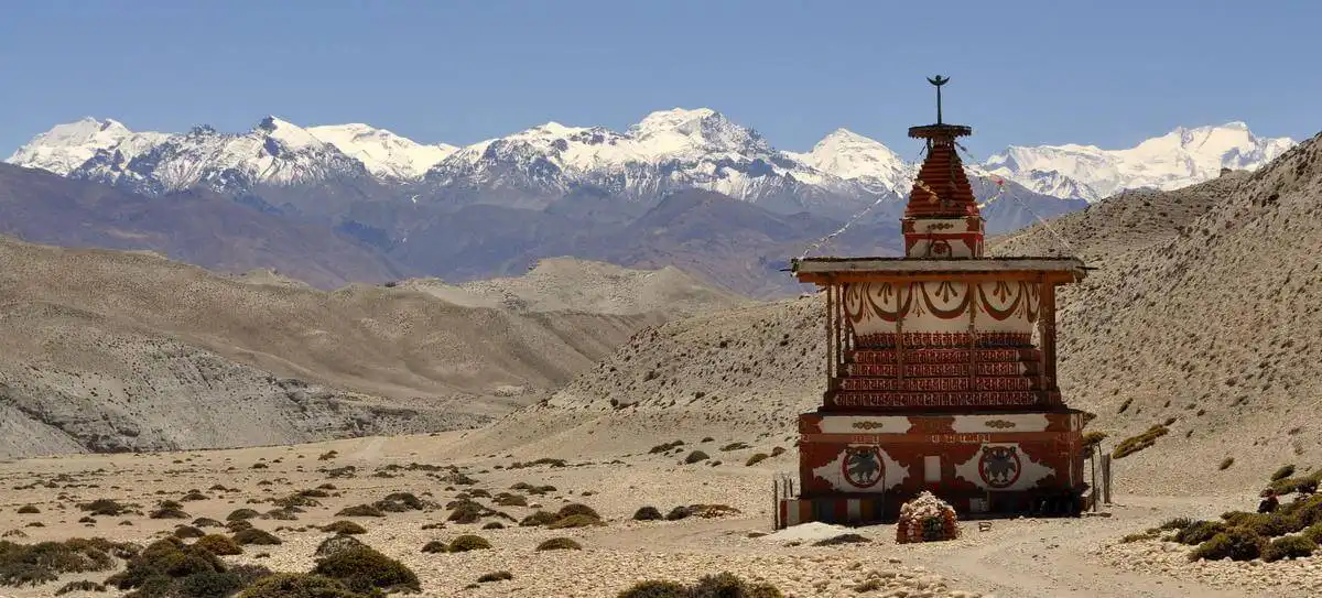
You’ll see Dhaulagiri, Kanjirowa, Putha Hiunchuli (7,246 m), passes like Kang La (5,306 m), Saldang La (5,200 m), Chharka La (5,336 m), Sangda La (5,118 m), and Lower Sangda La (5,125 m) along with rivers like Phoksundo and Tarap that have seen little change for centuries. Culture and tradition are everywhere. Festivals like Chhode and Lhosar (celebrated in February or March) fill the villages with ceremonies. Daily life revolves around yak herding, salt trading, and rituals that have lasted hundreds of years.
Wildlife is a part of the journey. Snow leopards, blue sheep, musk deer, and Himalayan griffons live here. The trek passes Shey Phoksundo National Park (3,555 km2), which protects forests, alpine pastures, and wetlands. So, step into a world few see. Walk high passes, visit ancient monasteries, and watch life flow in remote villages.
Upper Dolpo Trek Cost
The Upper Dolpo trek costs around USD 4,100-7,000, which is one of the most competitive prices available for this remote Himalayan adventure. Our agency offers this as a special discounted package, which makes it affordable without cutting any essentials. This price is designed to give you a full expedition experience, including flights, local transport, accommodation, meals, permits, guides, and porters.
The cost covers several critical aspects of the journey. Internal flights from Kathmandu to Nepalgunj and then to Juphal, often a major expense, are included. Accommodation in teahouses or camps, basic meals during trekking, and all necessary logistics, including contingency planning for weather delays, are also included. Additionally, a portion goes toward park conservation fees and local community support, which helps preserve Dolpo’s culture and environment.
Upper Dolpo Trek Itinerary
Day 01: Arrival in Kathmandu
Your Upper Dolpo adventure begins the moment you land at Tribhuvan International Airport in Kathmandu. After completing customs and immigration, our representative will greet you with a warm Nepali “Namaste” and a traditional garland. From the airport, you’ll be transferred to your hotel. The drive offers you a first glimpse of Nepal’s street life: food stalls lining the roads and small temples beside the road.
Once you settle into the hotel, the day is yours to rest or explore nearby streets. You might visit a café or stalls to enjoy your first taste of Nepali cuisine-perhaps dal bhat or momo dumplings. The day concludes with a welcome dinner, often featuring traditional Nepali cuisine, followed by an overnight stay at the hotel in Kathmandu.
Dinner
Hotel
1,300 m / 4,265 ft
Day 02: Kathmandu Sightseeing and Trip Preparation
Your second day in Kathmandu begins with a warm breakfast. Today, you’ll explore the UNESCO World Heritage Sites of Kathmandu that showcase history and architecture. The journey begins at Swayambhunath Stupa (the Monkey Temple) situated on the top of the hill. From the top, you can see the entire Kathmandu Valley. Then you’ll move to the Pasupatinath Temple, which is the most sacred Hindu site located on the banks of the Bagmati River.
After a local lunch, you’ll head to Kathmandu Durbar Square, the ancient royal palace area that once served as the seat of the Malla Kings. The wooden carvings, old courtyards, and the residence of the living goddess Kumari reflect the traditional Nepali culture.
Later in the afternoon, your focus shifts toward preparation. Our agency member will finalize all necessary paperwork, as individuals cannot obtain these alone. Your guide will review your packed equipment. If you need to buy or rent anything, you can do so in the nearby shops. A final, detailed briefing will confirm the itinerary for the coming days, review safety procedures, and confirm last-minute arrangements.
Breakfast, Lunch, Dinner
Hotel
5-10 km
1,300 m / 4,265 ft
8-9 hours
Day 03: Fly from Kathmandu to Nepalgunj
Today, you’ll leave the capital city and fly west to Nepalgunj. After an early breakfast, you’ll head to the domestic terminal of Tribhuvan International Airport for your short flight to Nepalgunj, a town near the Indian border. The flight takes about 50 minutes, giving you an aerial view of the middle hills of Nepal and the Terai plains. As you land, the sudden changes in climate are hard to miss; the cool air of Kathmandu turns into the warm, humid breeze of Nepalgunj.
Nepalgunj is the main gateway to western Nepal and the Dolpo region. After checking into your hotel, you’ll have time to rest and explore the local area. You can visit Mini Zoo, Bageshwori Temple, or simply walk on the streets. In the evening, your guide will give you a short briefing about tomorrow’s flight to Juphal mountain airstrip, which opens the door to Upper Dolpo.
Breakfast, Lunch, Dinner
Teahouse
519 km
150 m / 492 ft
50 minutes
Day 04: Fly to Juphal & Trek to Dunai
This morning begins with an early breakfast and a short flight from Nepalgunj to Juphal. This flight is the key part of the experience because it offers beautiful views of the Dhaulagiri and Annapurna mountain ranges as you transition from the flat Terai region into the Himalayas. It has a gravel airstrip, and flights are often scheduled in the morning due to the wind conditions. Here, you’ll meet the rest of your trekking crew.
The first leg of the trek begins from Juphal. The trail passes terraced fields and local villages where you can observe the daily lives of the locals. You’ll follow a small path leading to the Thulo Bheri River. The walk is relatively easy and serves as a good warm-up and acclimatization to the area.
By afternoon, you’ll arrive at Dunai, the administrative headquarters of the Dolpo district. Dunai is the largest town in the region, which consists of government offices, a police checkpoint, and small shops. You’ll set up camp and conclude your first day of trekking in Dolpo region.
Breakfast, Lunch, Dinner
Camping
381 km
2,140 m / 7,021 ft
35 minutes (flight) | 2-3 hours (trek)
Day 05: Trek to Chhepka
Your first full trekking day begins with fresh morning air. After breakfast in Dunai, you’ll start walking north on the bank of the Phoksundo River (Suligad River). After a short trek, you’ll reach Shey Phoksundo National Park, which is the largest national park in Nepal. Here, your permits will be checked at the park office before the trail heads deeper into the forest.
The route climbs toward Magar and Thakuri villages, where houses are built from stone and wood, and people still live traditional lifestyles. By afternoon, you’ll reach Chhepka village, which is surrounded by forest and terraced fields. You can explore fields or chat with locals who are known for their warm hospitality and stories about the upper valleys.
Breakfast, Lunch, Dinner
Teahouse
19 km
2,838 m / 9,311 ft
6-7 hours
Day 06: Trek to Chunuwar
After spending a night in Chhepka, you’ll continue following the Phoksundo River into more remote territory today. The trek becomes noticeably steeper in sections, with more challenging upward climbs compared to the previous day. You’ll trek dense forests of cedar, fir, and pine trees, and the scenery becomes wilder and adventurous with rock formations and waterfalls along the way.
You’ll pass small trail junctions and teahouses at Rechi, which is a common rest stop. The destination is near a traditional local healthcare clinic (Amchi Hospital), which is how the location sometimes gets its name. By afternoon, you’ll arrive at Chunuwar, a resting stop near the confluence of the Phoksundo and Pungmo Khola rivers. You’ll spend your night here.
Breakfast, Lunch, Dinner
Teahouse
17 km
3,120 m / 10,236 ft
6-7 hours
Day 07: Trek to Phoksundo Lake
The route initially climbs through the forest of birch and cedar, with views opening up as you gain elevation. The final part offers your first glimpse of Phoksundo Lake. You’ll pass the highest waterfall of Nepal, the Jharana (or Suligad) Waterfall, which cascades over 167 m into the river below.
The trail then descends through a birch forest to the traditional Bon village of Ringmo, situated on a landslide dam at the southern end of the lake. From here, a short walk takes you to the shores of Phoksundo Lake. You’ll set up the camp and rest while admiring the serene beauty of lake.
Breakfast, Lunch, Dinner
Camping
7 km
3,611 m / 11,847 ft
3-4 hours
Day 08: Acclimatization Day at Phoksundo Lake
Today is an acclimatization and rest day at Phoksundo Lake. A necessary pause before you venture into the higher and more remote sections of Upper Dolpo. But it’s far from a lazy day. The first thing you can do is to visit the traditional Tibetan Bon village of Ringmo. You can observe the local lifestyle, traditional houses, and terraced fields there.
You can also hike to the ancient Bon Tshowa Monastery, located on the ridge overlooking the lake. This 900-year-old monastery offers an insight into the Bon-Po culture, a pre-Buddhist Tibetan religion, and panoramic views of the area and Kanjirowa Himal.
Use this day to capture the scenery, meditate, or simply rest at the campsite. It’s a perfect day to recover, reflect, and ready yourself for the next leg of your trek.
Breakfast, Lunch, Dinner
Camping
0 km
3,611 m / 11,847 ft
0 hours
Day 09: Trek to Sallaghari
The altitude change today is minimal in the net gain (only 8-9 m higher than the lake), but the trail involves significant ups and downs. This section is considered one of the most exciting and challenging parts of the trek as it contours the western bank of Phoksundo Lake. It requires a careful footing as you traverse several cliff sections. Our team will also be there to assist you during the more challenging sections.
After about an hour of trekking, you’ll reach Sallaghari, which literally translates to “Pine Forest”. This campsite is a small, flat area located in a forest of pine of juniper trees at the far northern end of the lake. You’ll rest in the camp of Sallaghari, ready to continue into the upper Dolpo region the next day.
Breakfast, Lunch, Dinner
Camping
11 km
3,620 m / 11,877 ft
5-6 hours
Day 10: Trek to Nagdalo La HC
The trek leaves the general lake area and heads into a narrow glacial valley. The path follows the course of the Tuk Kyaksa Khola (river), passing through a few forested sections along the way. The landscape starts to change from lush pine forests to more sparse, dry, and rocky terrain with bushes as you gain elevation.
With 6-7 hours of trekking in a day, you’ll reach Phoksundo Bhanjyang, also referred to as Nagdalo La High Camp or Kang La Base Camp. Our team will set up the camp soon after they arrive there. This strategically located campsite is a crucial staging point situated just below the challenging Kang La (Nagdalo La) pass you will cross on Day 11.
Breakfast, Lunch, Dinner
Camping
10 km
4,700 m / 15,420 ft
5-6 hours
Day 11: Trek to Shey Gompa via Nagdalo La Pass
You’ll undertake one of the most challenging segments of the trek today: crossing the high Nagdalo La Pass (5,360 m). The day begins early to navigate the rugged and potentially snowy trail. Starting from the high camp at Phoksundo Bhanjyang, you’ll climb for several hours to reach the pass.
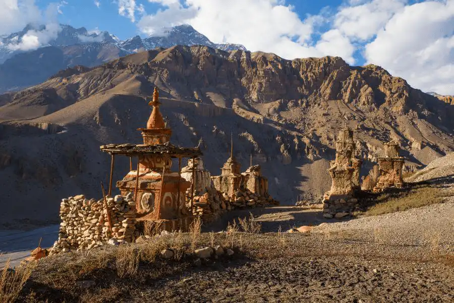
The pass is also known as Kang La. From its summit, you can see the entire Dolpo region, including the Crystal Mountain (Shey Shikhar), and the Tibetan plateau. The trail on the other side of the pass is equally challenging. You’ll make a long descent on a slope before reaching grassy meadows. The final leg of the trek leads you into the area of Shey Gompa, also known as the Crystal Monastery. This monastery holds a deep connection to both Bon and Tibetan Buddhist traditions.
Breakfast, Lunch, Dinner
Camping
17 km
4,390 m / 14,403 ft
6-7 hours
Day 12: Trek to Namgung Gompa via Sela La Pass
Another high and inspiring day begins as you leave Shey Gompa behind. The trek begins by following the Sephu Khola (stream) for a couple of hours before you begin the long ascent to the pass. From the summit of Sela La towards the north, you can see the landscapes of the Tibetan plateau, to the east, the Mustang region is visible along with Kanjirowa, Kagmara, and Crystal Mountain peaks.
After enjoying the views, you’ll make a long descent down into the next valley that reveals scattered stone huts and yak caravans. From there, you’ll reach Namgung Gompa, which is built from red stone. It is one of the isolated religious sites of Dolpo, which is home to monks who live simple lives dedicated to meditation and prayer.
Breakfast, Lunch, Dinner
Camping
12 km
4,430 m / 14,534 ft
5-6 hours
Day 13: Trek to Namduna Gaun
Today’s trek involves a slight net loss in elevation, from Namgung Gompa down to Namduna Gaun. The path follows the course of a small stream, but it is not a flat walk. You’ll walk on dusty, bare, and arid landscapes that resemble the Tibetan plateau. The landscape has barren hills and sparse vegetation, showing that Upper Dolpo is in a dry, rain-shadow region.
As you walk, you’ll pass several chortens and mani walls, which indicate the presence of Tibetan Buddhism and the Bon culture. The open landscapes provide opportunities to spot local wildlife, such as blue sheep, marmots, and various high-altitude birds of prey.
The destination is a small, traditional village with flat-roofed stone houses clustered together. The highlight of the village is the Namduna Monastery, an ancient gompa that is a cultural landmark in the region. You’ll set up camp near the village and take some time to explore the ancient monastery to release the stress.
Breakfast, Lunch, Dinner
Camping
10 km
4,200 m / 13,780 ft
5-6 hours
Day 14: Day Hike to Saldang Village
Today’s trek involves an uphill climb followed by a descent into the Namga Khola River. After leaving Namduna Gaun, the path climbs a barren slope for several hours. As you reach the high point, you’ll see the Saldang Village spread out on a plateau below. The final part of the trek is the descent to the village.
Saldang is the largest village in the inner Dolpo area, with approximately 80 well-built households and a population of around 600 people. The village is heavily influenced by Tibetan culture, from the architecture to the language and dress of the locals. Situated on a trade route to Tibet, Saldang has been a prosperous agricultural and trading hub for centuries.
Breakfast, Lunch, Dinner
Camping
12 km
3,700 m / 12,139 ft
5-6 hours
Day 15: Trek to Yangze Village
On this day, you’ll you’ll trek further into the high, barren landscapes of Upper Dolpo, moving north from Saldang to reach Yangze Gompa. The path follows the Nagon Khola (river) in a northern direction. You’ll pass the smaller, more isolated settlements of Marang and Ki villages on the way. The trek also involves crossing a tributary of the Panzang River before you finally arrive at Yangze Gompa.
The area is named after the old Bon monastery located there. You’ll get a chance to explore one of the least-visited regions of Nepal and the traditional Bon culture. The evening is peaceful here, offering a chance to rest and prepare mentally and physically for the next stage of your trek toward the high passes and more remote villages.
Breakfast, Lunch, Dinner
Camping
15 km
3,980 m / 13,058 ft
6-7 hours
Day 16: Trek to Namdo Village
After your stay at the remote Yangze Gompa, this day of the Upper Dolpo trek requires a change of direction to continue towards the next stop of the journey. Instead of pushing forward north, you’ll retrace your steps south before heading east towards Namdo Village. From there, the path leads alongside the Nam Khola (river) through terraced fields, chortens, and mani walls, before reaching Namdo Village.
It is also one of the largest permanent settlements in Upper Dolpo. It has a small monastery, a few teahouses, and stone houses built in the traditional style. The village is a hub of cultural and religious activity, with local families engaged in barley farming, yak herding, and trading wool or salt. Here, you’ll rest, acclimatize, and prepare for further journeys.
Breakfast, Lunch, Dinner
Camping
18 km
3,780 m / 12,402 ft
6-7 hours
Day 17: Trek to The Jeng La Phedi
On this day, you won’t cross the Jeng La Pass itself but rather trek from Sibu to the high-altitude base camp below the pass, known as Jeng La Phedi. The day begins by following the Nam Khong Khola (river) for a while, so you head eastward. The trail eventually leaves the main river valley and starts an uphill climb towards a grazing pasture area below the pass. The path can be rocky and rugged.
It’s common in this section to encounter yak caravans transporting goods on the ancient trade routes that connect to the Tibetan border. Your destination is Jeng La Phedi (meaning “foot of the pass”). This campsite is a high, exposed pasture area. The high altitude of the camp is important for acclimatization before tackling the pass tomorrow morning.
Breakfast, Lunch, Dinner
Camping
14 km
4,200 m / 13,780 ft
5-6 hours
Day 18: Trek to Tokyu
You’ll start the day early to tackle the approximately two-hour climb to the top of the Jeng La Pass. The trail is rough and rocky, but the altitude gain is manageable starting from the high camp. From the summit of the pass, you can see the north face of Dhaulagiri I (8,167 m).
After the pass, you’ll walk downward into the Tarap Valley. The landscape below opens up into plains and marshy grasslands located beside the Tarap Chu River. After a short trek, you’ll arrive at Tokyu Gaon, which is one of the highest human settlements in the Himalayas and a large village with several monasteries, including a Bon-Po monastery.
Breakfast, Lunch, Dinner
Camping
15KM
3,950 m / 12,959 ft
6-7 hours
Day 19: Trek to Dho Tarap
Today you’ll trek from Tokyu to Dho Tarap, one of the most remote villages of Upper Dolpo. After breakfast, the trail begins with a climb on rocky terrain and narrow ridges. You’ll pass chortens and mani walls, highlighting the strong Buddhist/Bon culture that is prevalent here.
You’ll reach Tarap village at noon due to the very short duration of the trek. It is one of the permanent settlements in the Dolpo region, which is inhabited all year round. It is a culturally rich village located at the confluence of two streams. This village serves as a trading post and administrative center for the surrounding region.
You can spend the afternoon exploring the village, visiting small monasteries, and interacting with the locals, known as the Dolpopa people. The area is rich in history and traditional practices.
Breakfast, Lunch, Dinner
Camping
12KM
3,860 m / 12,664 ft
5-6 hours
Day 20: Rest Day in Dho Tarap
The primary goal of this day is rest and active acclimatization to help your body recover and adjust to the altitude. Tarap is a cultural hub. You can spend time strolling the village, observing the daily lives of the Dolpopa people, who have preserved their Tibetan-influenced culture for centuries. The traditional architecture of the houses is a highlight.
The area around Dho Tarap is home to several important monasteries, such as Ribo Bhumpa Gompa and Shiwar Shartshang Gompa. You can visit them too. This is an excellent opportunity to interact with local families, perhaps sharing a cup of su-cha (Tibetan butter tea), and learning about their unique high-altitude way of life, including yak herding and trade with Tibet.
For those who feel energetic, a short hike up to the surrounding hills can aid acclimatization (“climb high, sleep low”) and offer beautiful views of the entire Tarap Valley.
Breakfast, Lunch, Dinner
Camping
0 km
3,860 m / 12,664 ft
0 hours
Day 21: Trek to Tarap Khola
Your day starts by following the Tarap Chu River downstream, which enters a narrow canyon. The path passes dense juniper and wild rose bushes as you head forward. You’ll reach the confluence of the Tarap Chu and Lang Khola rivers from where you’ll descend.
As you trek downhill, the arid, high-altitude landscapes will start to give way to thicker vegetation. The open terrain provides a good opportunity to spot blue sheep. Your destination is the meadow of Kamakharka, a scenic spot near the Tarap Khola, where you’ll set up your camp for the night.
Breakfast, Lunch, Dinner
Camping
14 km
3,650 m / 11,975 ft
5-6 hours
Day 22: Trek from Dho Tarap to Khanigaon
You’ll continue to descend from the high-altitude region towards lower, more forested areas. The path follows the Tarap Khola (river) valley as it begins to narrow from a broad valley into a deeper gorge. The trail can be adventurous and rugged, with stone slabs, log bridges, and potentially even crossing the river on foot if bridges are washed away or damaged.
The landscape changes noticeably as you descend into warmer climates and more vegetation. You may encounter local shepherds bringing their flocks to lower pastures for the winter. Your destination is the small village area of Khanigaon, a peaceful spot near the river where you will set up camp for the night.
Breakfast, Lunch, Dinner
Camping
18 km
3,200 m / 10,499 ft
6-7 hours
Day 23: Trek to Tarakot
The trek primarily follows the course of the Tarap Khola (river), where you may need to navigate steep slopes and narrow paths. As you go down the dry, rocky landscape of Upper Dolpo turns into greener valleys filled with pine and juniper trees. On the way, you’ll encounter various chortens and mani walls, indicating a Buddhist and Bon-Po religious influence.
After hours, you’ll reach the Tarakot Village. The village was once the capital of the ancient independent Tichorung Kingdom. Its name, “Tarakot,” literally means “fortress” or “castle,” and is built on a small hillock above the river for protection from other kingdoms.
You’ll camp in the pasture below the main Tarakot village, near the river banks, where you’ll spend your night.
Breakfast, Lunch, Dinner
Camping
16 km
2,750 m / 9,022 ft
5-6 hours
Day 24: Trek to Dunai
The trail retraces a portion of the route you took on Days 4 and 5, but this time you’ll be trekking downstream the Bheri River System. The path is well-marked and relatively easier than the high-altitude trails of Upper Dolpo. As you move further downstream, the landscape becomes warmer, greener, and more populated with farming villages and terraced fields.
You’ll pass several small villages and hamlets, which offer the final opportunity to observe the traditional lifestyle of the mid-hill people of the region before reaching Dunai. Dunai is the largest village and administrative center of the Dolpo district. You’ll find slightly better amenities here than in the remote Upper Dolpo villages.
Breakfast, Lunch, Dinner
Teahouse
20 km
2,140 m / 7,021 ft
6-7 hours
Day 25: Trek from Dunai to Juphal
The trek is relatively short and easy, where you’ll walk through the lower Bheri River Valley. You’ll pass several small settlements and terraced fields, including villages like Dhupichaur, Rupgad, Kalagaonda, and Motipur. The final step involves a somewhat steep climb up to the airstrip area of Juphal.
Upon arrival, you’ll check into a local teahouse and freshen up for the evening. This evening is a time for rest, reflection, and celebration of the successful completion of the Upper Dolpo circuit trek with your guide and porter team.
Breakfast, Lunch, Dinner
Teahouse
19 km
2,590 m / 8,497 ft
6-7 hours
Day 26: Fly from Juphal to Kathmandu via Nepalgunj
It is time to begin our journey back to Kathmandu and take two short flights – from Juphal to Nepalgunj and then to Kathmandu. Flights from Juphal (Dolpo Airport) are usually scheduled early in the morning because wind conditions in the mountain gorges can become unpredictable later in the day. You’ll board a small unpressurized aircraft (typically a Twin Otter or Dornier) for this journey. You can see the final aerial view of the Himalayan ranges you have just traversed.
After landing at Nepalgunj, you’ll change aircraft for the larger domestic flight to Kathmandu after a short layover. The second flight takes you across the different regions of Nepal, moving from the hot, flat Terai plain of Nepalgunj back to the Kathmandu Valley.
Breakfast, Lunch, Dinner
Hotel
716 km (flight)
1,300 m / 4,265 ft
1 hour 30 minutes (flight)
Day 27: Final Departure
It’s time to fly home! Say goodbye to Nepal and your fellow trekkers! A representative from our trekking company will transfer you to the Tribhuvan International Airport (TIA). You’ll proceed through check-in, customs, and immigration for your flight home.
Breakfast
Hotel
0 km
1,400 m / 4,593 ft
0 hours
Upper Dolpo Trek Map
What To Expect?
What's Included
- Airport/hotel pick-up and drop-off by private car.
- At least two nights in a 3-star hotel in Kathmandu, bed and Breakfast plan
- Meals on the entire board (breakfast, lunch, and dinner) during the whole trek
- Fly from Kathmandu – Nepalgunj – Jhuphal – Nepalgunj and then to Kathmandu
- Trekking map
- An experienced Government-licensed guide
- A trekking porter/Sherpa who will carry your bags during the trek
- Insurance, salary, equipment, transportation, local tax for guide and porter
- Group medical supplies (a first aid kit will be available)
- All necessary paperwork and national park entry permits
- Travel and rescue arrangements
- TIMS (Trekkers’ Information Management System)
- All government taxes and tourist service charges
What's Excluded
- Meals in Kathmandu before and after trekking
- Your travel insurance ( Rescue )
- Nepal entry visa fee.
- Tips for trekking staff and driver
- Drinks (hot, cold, and alcoholic)
- Personal shopping, laundry, etc
- Personal trekking equipment
Tripadvisor Reviews
Google Reviews
Upper Dolpo Trek Additional Information
Can We Trek Upper Dolpo Solo?
No, solo trekking in Upper Dolpo is not allowed. The Government of Nepal made this rule official in 2012 through the Department of Immigration. To trek here, there must be at least two trekkers in a group along with a registered and licensed guide. The region lies inside a restricted zone near the Tibetan border, and the government monitors entry to both trekkers and local communities. This rule helps to prevent accidents, smuggling, and unauthorized border crossings.
The Upper Dolpo trek is suitable for experienced trekkers, couples, or small groups who can adapt to long days and remote conditions. It’s not ideal for first-time trekkers or solo travelers who prefer independence, as the trail passes isolated landscapes with no phone network, limited rescue options, and few settlements. The guide plays a key role; they manage the route, handle local communication, and assist in emergencies. So hire a guide for further safety.
Exploring the Culture of Dolpo
We can observe three kinds of culture in Dolpo: lower, upper, and middle. Hindus inhabit the lower region, while the middle area is home to a blend of Hindu and Buddhist people, including those practicing Shamanism and Boni. A cluster of Magar people speaks the typical “Kaile” language.
The Upper region was home to Buddhist and Bon cults. Tibetan Buddhism has driven the culture of these “Dolpo-pa.” The people speak the ‘Khaam’ or ‘Poike’ language and strictly follow their culture. Bönpo monasteries, such as Shey Gompa, are the foremost destinations for pilgrims aiming to complete the circuit trek.
The salt trader first used this trail, and the story was depicted in the movie called “Himalaya” by Eric Valli. During the summer, this route was a trade route for “Yarchagompa” (caterpillar fungus). You can also participate in the unique Festivals of Upper Dolpo. Check Cultural tours of Nepal.
Permits for Upper Dolpo Trek
Trekking in the restricted region of Upper Dolpo requires multiple permits for both safety and conservation of the remote Himalayan environment.
| Permits | Cost | Notes |
|---|---|---|
| Upper Dolpo Restricted Area Permit | USD 500 per person (for the first 10 days) | After the first 10 days, an additional fee of USD 50 per person per day is charged |
| Shey Phoksundo National Park Entry Permit | USD 22 per person | This is a one-time entry fee, regardless of the duration of your trek |
Best Time for Upper Dolpo Trek
- March-May: Snow melts on high passes. Rivers are easier to cross, and spring flowers bloom in the lower village. You can try between these months.
- June: Early monsoon clouds reach Dolpo late, so trails remain mostly dry. Yak herders move to higher pastures. It is also feasible to trek.
- September-October: Clear skies return. High passes are accessible, which offer perfect visibility for Kanjirowa and Dhaulagiri views.
- November: Cold sets in, but fewer trekkers are on the route. You can try, but with proper preparation.
- December-February: Extremely cold and windy. Only experienced trekkers are suggested to go.
- Avoid July-August: Monsoon hits Dolpo late. Heavy rain, slippery trails, and limited visibility make trekking difficult.
Accommodation in the Dolpo Region of Nepal
- Camping: In the Upper Dolpo region, camping isn’t just an option. It’s the only reliable way to rest after long days of trekking in remote valleys. You’ll sleep in dome tents provided by our agency. A full support crew, including guides, cooks, and porters, manages everything from cooking meals to pitching tents before you arrive. Meals are prepared using local ingredients like rice, lentils, potatoes, and yak butter. The camping equipment used is of expedition-grade quality, designed to handle sub-zero nights that often drop below -5°C even in summer.
- Teahouse and Homestay: In Lower Dolpo, around Dunai, Tarakot, and Phoksundo Lake, you can stay in small family-run teahouses or basic homestays. These aren’t luxury lodges. Most are built from stone and wood, which offer shared rooms with simple beds and thick blankets. Electricity is often limited and powered by solar panels, and hot showers are available only in a few places for a small extra cost.
How Difficult is the Dolpo Trek?
Upper Dolpo Trek is considered to be one of the 15 top difficult treks in Nepal, and these are the reasons why:
- You’ll start in the river valleys around 2,000 m, feeling normal and light legs, but by day five, the air thins above 4,000 m, and every step demands more energy.
- Kang La Pass reaches 5,350 m, where dizziness, headaches, and breath loss test your endurance.
- The journey lasts 20-27 days, with villages far apart and some camps offering nothing but rocks and wind.
- The weather can change in hours, with normal mornings turning to storms and winter nights dropping below -20 °C.
- Rivers can swell unexpectedly, flights may be canceled, and roads sometimes get destroyed, demanding flexibility and mental readiness.
- The remoteness adds another layer of difficulty, as medical help is scarce and rescue options are limited.
Guides and Porter for Upper Dolpo Trek
- Guides: Our guides for the Upper Dolpo Trek are highly experienced and have been working with our agency since 2015. They know the trail in detail, including high passes like Kang La and Sela La, remote villages such as Ringmo, Saldang, and Namdo, and the most reliable routes around rivers and landslides. They are trained to recognize signs of altitude sickness, sudden weather changes, and emergency situations. Beyond navigation, they provide knowledge about Bon and Tibetan Buddhist practices, traditional festivals, and wildlife in Shey Phoksundo National Park.
- Porter: Porters are trained to carry up to 25-30 kg of load, helping you with food, tents, sleeping bags, and personal gear. They accompany you throughout the trek, from Juphal to Shey Phoksundo Lake, High Camp, and other remote areas. It is important to respect their work by providing proper support, breaks, and fair treatment. Giving small tips at the end of the trek is customary, with the average ranging from USD 10-15 per porter depending on trek length and service.
Why You Should Choose My Everest Trip for Upper Dolpo Trek
- Our guides have led expeditions in Dolpo since 2015, mastering every trail, high pass, and hidden valley.
- The total cost includes all essentials: flights, permits, food, tents, porters, and guides.
- We work directly with Dolpo villagers, lodge owners, and local guides.
- From flight bookings to emergency coordination, every step is handled in advance.
- We keep our groups limited to maintain personalized care, better acclimatization, and genuine team spirit on long remote trails.
- Our staff secures all required permits for you-no paperwork stress.
- We follow a strict “Leave No Trace” policy, managing waste responsibly and using reusable gear wherever possible.
- You get real trail information, not exaggerated marketing lines.
- We share facts about terrain, risks, and preparation so you know exactly what to expect.
- We also provide last-minute booking for Upper Dolpo Trek if you are unsure right now.
Gear and Equipment
The essential gear and equipment during the camping trek are:
Gear
- Sleeping Bag
- Trekking poles
- Water bottle
- Headlamp or torch
Upper Body
- Half-gloves
- warmer hat
- Sunglasses
- Neckwarmer
- Sunscreen
- A headlamp and an extra set of batteries
- long-sleeved t-shirts
- Thermal tops
- wool jacket
- Water and windproof shell jacket
Hands
- Half gloves for walking poles
- Gloves and liner
Lower Body
- Windproof and waterproof trousers
- Warmer trousers
- Comfortable trekking pants
Footwears
- Waterproof trekking boots
- 4-5 pairs of woolen socks
- Sock liners
- Light shoes and sneakers
Personal Items
- First Aid Kits and Medicines
- Water purifying pills
- Toiletries
- Power adaptor and charger
- Travel towel
Upper Dolpo Trek FAQs
Can I buy trekking gear in Dunai or Juphal?
You can find only basic trekking gear like walking sticks, gloves, or caps in Dunai or Juphal. For professional equipment such as sleeping bags, down jackets, or hiking boots, it’s best to purchase or rent them in Kathmandu before the trip.
Do villagers in Dolpo speak English?
Only a few villagers and lodge owners speak basic English. Most people speak Dolpali, Tibetan, or Nepali. Guides act as translators during your stay. A few friendly gestures or learning simple Nepali words like “Namaste” (Hello) can go a long way in connecting with locals.
Are horses or mules used during the trek?
Yes, horses and mules are used to carry supplies and baggage in high-altitude areas. Some trekkers even ride horses if they fall sick or tired. However, the terrain is rough, so horse rides are limited to certain sections only.
Can I use a satellite phone on this trek?
Yes, satellite phones work well in Dolpo and are often carried by guides or expedition leaders. Regular mobile networks are unavailable in most parts. So, having a satellite phone helps in emergency communication when needed.
Can I get a permit on arrival at Dunai?
No, you cannot get permits in Dunai. All permits for Upper Dolpo must be issued in Kathmandu through a registered trekking agency before departure. Without these, local authorities won’t allow you to proceed beyond the Lower Dolpo region.
What if my trekking shoes get damaged mid-trek?
If your shoes tear or break, it’s hard to find replacements in remote Dolpo villages. Locals might help repair them using leather or rope, but it won’t last long. Always carry duct tape, spare laces, and a small repair kit as backup.
I have mild asthma; can I do the Upper Dolpo Trek?
Yes, you can, but only with medical approval and preparation. Carry your inhaler, medication, and travel insurance covering altitude issues. Inform your guide beforehand. Since the air gets thin above 4,000 meters, it’s best to walk slowly and rest often to avoid breathing problems.
What if I lose my guide or get separated?
Stay calm and wait at the nearest village or trail marker. Do not continue alone, as trails often split in Dolpo. Guides usually backtrack once they notice you’re missing. Keeping a whistle, a map, or a walkie-talkie can help to prevent such situations.
What happens if I accidentally touch a monastery relic?
It’s not a big issue if it’s unintentional, but apologize politely. Sacred items hold spiritual meaning in Dolpo. Locals appreciate respectful behavior and understanding of their traditions. Avoid touching statues, prayer wheels, or offerings unless guided.
Can I send a parcel from Dolpo to Kathmandu?
No, there’s no postal or courier service in Upper Dolpo. If you want to send something, you must hand it to someone traveling back to Nepalgunj or Kathmandu. Communication and delivery systems are extremely limited in this region.
Can I give sweets or gifts to local children?
It’s kind, but not recommended. Giving candies or gifts can create dependency habits among children. Instead, you can donate school supplies through your guide or local teachers. That way, your kindness helps in a sustainable way.
Can I see stars clearly at night in Dolpo?
Yes, Upper Dolpo is one of Nepal’s best places for stargazing. With no city lights or pollution, the Milky Way and countless stars are seen at night. Many trekkers enjoy lying outside their tents just to watch the sky.
Can I carry a suitcase instead of a backpack?
No, a suitcase isn’t practical for this trek. Trails are rocky, steep, and uneven, so porters can’t roll or balance a suitcase easily. Always bring a duffel bag or trekking backpack instead. Suitcases can be left safely at our agency in Kathmandu before the trek begins.
Can I wash clothes during the trek?
Yes, you can wash small items like socks and T-shirts in some villages using cold water. However, drying is difficult due to the cold and limited sunlight. It’s better to carry enough quick-dry clothes for the whole trek to stay clean and comfortable.
Can I listen to music while trekking?
Yes, but do it with one ear open. Listening to music is enjoyable, but hearing your surroundings is important for safety, like approaching animals or people. Also, avoid loud music near monasteries or sacred sites to respect local culture.
US$ 4,900 per person
- Best Price Guarantee
- Secured Payment System
- Tailored and Personalized Itinerary
- 70% repeat customers
24 X 7 Live Support

Puru (+977-9851069558)